Bushfires: Survey reveals catastrophic damage to productive land
Nearly a million hectares of prime agricultural land has been damaged by bushfires, according to a fire zone survey.

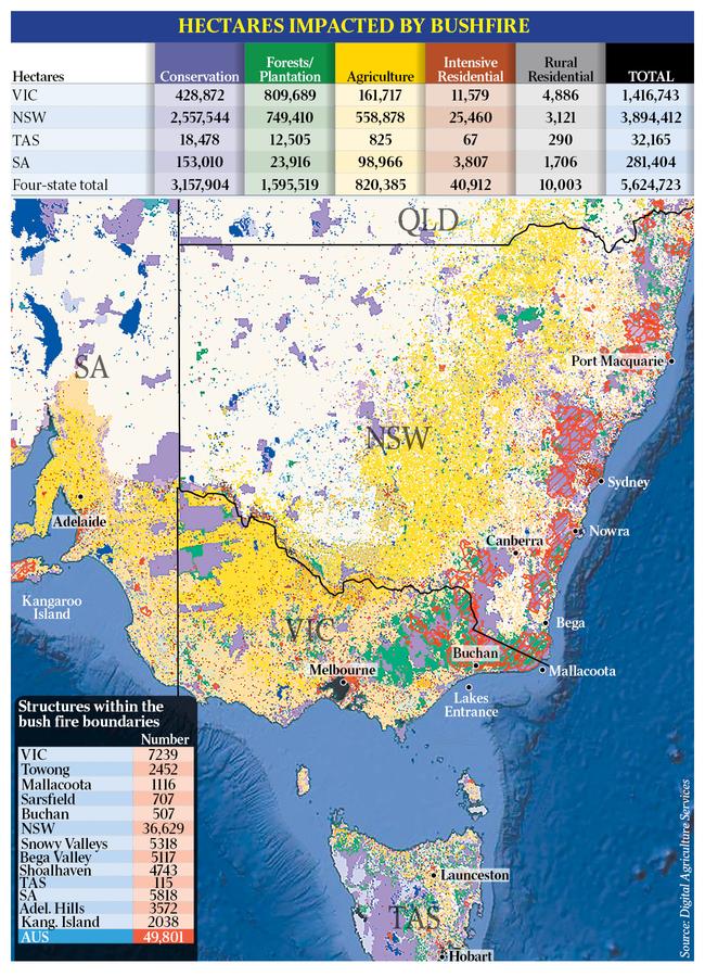
Nearly a million hectares of prime agricultural land has been damaged by bushfires, along with more than 1.6 million hectares of logging forests and tree plantations, according to the first scientific study matching fire zones to land use.
The analysis by private satellite mapping consultants Digital Agriculture Services shows almost as much productive land has been caught up in the infernos as national parks and other conservation zones, 3.2 million hectares of which are in the bushfire areas defined by four states.
The DAS study records the biggest proportional impact of the fires in national parks and forestry, particularly in NSW, where official bushfire boundaries cover 25 per cent of conservation areas and 30 per cent of native production forests and tree plantations.
It shows nearly 50,000 structures are within the fire zones, though it is not known how many of those have been destroyed and how many were saved.
The maps show where state fire authorities say land is burnt out, burning, or still in danger.
The DAS study provides an initial taste of what is likely to be a significant adverse impact on the agriculture and forestry sectors, which will expand until the still-spreading bushfires around the nation are brought under control.
It comes amid warnings of a spike in food and dairy prices, and could signal the risk of job losses in both forestry and farming.
“What we know is that some of our most productive land is on the east coast of Australia and in the fire zones,” DAS chief executive Anthony Willmott told The Australian on Tuesday.
The DAS report also shows that the bushfires are concentrated in areas of severe drought, and demonstrates a high correlation between current fires and known topographical and fuel load risks.
For years, DAS has used satellite imagery and state and federal government data on land use to make precise assessments of agricultural activity and resources on individual rural properties.
The satellite data is of such a high resolution that it can distinguish between wheat and barley, and can gauge crop productivity.
The DAS property assessments are sought by banks and insurance companies to value properties and assess risk, but DAS also makes the material available to farmers.
“At the moment, we estimate the productivity of every paddock in Australia, looking at the biomass growth on those properties,” Mr Willmott said.
The official bushfire boundary maps for NSW, Victoria, South Australia and Tasmania were developed by the Emergency Management Spatial Information Network Australia, with the assistance of Geoscience Australia.
DAS matched its own data on land use with the fire zone maps.
“Now we know where the fire is, we asked, what type of land is it?” Mr Willmott said.
Queensland and Western Australia have yet to release their bushfire boundary maps, so the DAS analysis only covers the four states with declared fire zones totalling 5.6 million hectares, compared with other national estimates including Queensland and Western Australia, closer to seven million hectares. The DAS assessment of 820,000ha of agricultural land in the fire zones in four states is, as a result, not a national total. That would be closer to one million hectares.
NSW has borne the brunt of the damage, with 560,000ha of agricultural land in the fire zones, while Victoria had more logging forests and tree plantations in the blazes — 810,000ha, compared with 750,000ha in NSW.
NSW also accounted for the lion’s share of the fires in national parks and other conservation zones, at 2.6 million hectares out of a four-state total of 3.2 million hectares. And of the nearly 50,000 structures that were in the fire zones, 37,000 were in NSW.
The DAS study found 86 per cent of the fire-affected areas in the four states are suffering a one-in-10-year rainfall deficit, and 63 per cent are experiencing a one-in-20-year rainfall deficit.
The analysis shows how work DAS had done with the CSIRO in 2018 to create a “fire risk score” for all rural properties based on topography and fuel load was a very effective predictor. Those properties in the fire zones had a mean fire risk score near the top.
“We have found that the mean fire risk index for properties that fell within the fire boundaries was 0.93 (with a maximum of 1),” DAS said. “That is, the highest-risk index values are where crown fires are likely to occur in forests and firestorms will develop. The lowest (-risk) index values are where a fire would struggle to stay alight.”
Add your comment to this story

Ley won’t change net-zero stance as senior Nats vow to fight it
Sussan Ley says she will leave the policy for an internal Coalition review to decide, as Barnaby Joyce and Michael McCormack declare their intention to repeal Australia’s commitment to it.

‘No longer a failure if you drop out’: Adelaide’s vision
The mega-university’s degree overhaul shows how the traditional tertiary degree is changing.
To join the conversation, please log in. Don't have an account? Register
Join the conversation, you are commenting as Logout