
Gripped by our climate of fear
Devastatingly intense weather events, record temperatures and shifting patterns mark a decade of extremes.

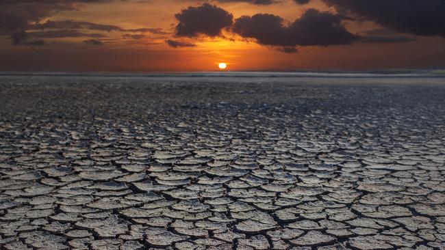
Wherever you stand in the climate change debate, one thing is indisputable: it’s been one hell of a decade weatherwise.
The 2010s started with a big wet and have ended with a big dry, earlier-than-usual bushfires and record temperatures.
Did we imagine it or was this an exceptional decade and, if the latter, what factors were at play?
For most of us, living year to year, it’s hard to know, of course. Our conversations tend to be influenced by the here and now.
“It never used to be this hot,” is the refrain as we brave the barbecue in the middle of a summer heatwave. Or else it’s a bitter “so much for global warming!”, as we stoke the home fire on a bitterly cold midwinter evening.
However, the data and the experts both suggest the decade now coming to a close was not business as usual, at least across several key measures.
“It’s definitely been a decade of extremes,” says Anna Ukkola, climate scientist and research fellow at the Australian National University.
The hottest topic right now is temperature. “It is the hottest decade on record over all of Australia,” Ukkola says. “It’s about one degree hotter than the average of the last 100 years.
“We’ve now had four decades in a row that have been hotter than the average, with the last one being the hottest of them all. It holds pretty much across Australia. The temperature trends are very similar.”
The Bureau of Meteorology tends to compare annual observations to those seen between 1961 and 1990, as a kind of scientific control period. The conclusion, however, is very similar.
“It will be clearly Australia’s warmest decade on record,” says Blair Trewin, BoM senior climatologist. “It’s most likely going to come in around 0.85 of a degree above the 1961-90 average, which will make it about 0.3 of a degree warmer than any previous decade. It also looks like being the record warm decade for every individual state and territory.”
Trewin says that since 2013, every year has been among the top 10 warmest years on record in Australia, and that every year of the decade except 2011 recorded above annual mean temperatures (2011 was merely average).
GRAPHIC: Australia’s weather in the 2010s
The country’s warmest year, in records stretching back a century, was 2013, although the last days of this month may yet see this overtaken by 2019.
The year drawing to a close is already on track to be among the four warmest years on record, with the final annual mean temperature expected to be 1.3C to 1.4C above average.
Heatwaves aren’t what they used to be, either; they’re worse. “With the increase in mean temperatures, we also see an increase in the occurrence of extreme high temperatures,” Trewin says.
The BoM says very high monthly maximum temperatures that used to occur only 2 per cent of the time in the past (1951-80) now occur 12 per cent of the time.
It suggests this decade has seen Australia’s worst heatwaves, with the country recording the three hottest days on record.
As well, the BoM reports that Sydney, Hobart and Adelaide all had their hottest days on record during this decade.
Natural variations in climate undoubtedly have played a role in all this mercury-soaring record-busting. Australia always has been, and always will be, a land of “droughts and flooding rains”, as Dorothea Mackellar would have it. Cyclical changes in the Pacific Ocean and the atmosphere above it give us the El Nino and La Nina weather patterns with which most Australians are now familiar.
The big wet experienced from mid-2010 to early 2012 was, for example, linked to a strong La Nina, bringing record rains to Queensland in 2010 and to Western Australia in 2011.
Natural differences in the sea surface temperatures in the western and eastern parts of the Indian Ocean — known as the Indian Ocean Dipole — also affect our climate.
A “positive” IOD typically brings less rainfall to southern Australia and the Top End and a “negative” IOD is linked to more rain in those regions.
This year, for example, a positive IOD has been a key player in the heat and drought conditions experienced in many regions.
Back in 2016, a very strong negative IOD saw unusually heavy rain throughout parts of eastern Australia between May and October.
However, several leading climatologists who have examined the decade as whole, and those preceding it, do not believe the extreme conditions of the 2010s can be explained entirely by such natural ebb and flow.
“One of the advantages of looking at averages over a decade is that it will tend to smooth out a lot of that year-to-year variability,” Trewin says.
“So if you look at the decade as a whole we’ve had La Ninas but we’ve also had El Nino, we’ve had both positive and negative IODs. The fundamental underlining picture with the warming decade is the long-term warming trend.”
Ukkola agrees. “In terms of the temperature, looking at the long-term context, it’s way outside natural variability,” she says.
“It’s a clear climate change signal and the temperatures are well above what we have seen for Australia in the past.”
One of the regions to feel the heat the most has been the Murray-Darling Basin, where farmers in one of the nation’s key food bowls continue to battle drought.
“Over the Murray-Darling Basin we have now had 12 consecutive seasons — so the last three years — in a row that have been below the long-term average (rainfall) conditions,” Ukkola says.
“That’s the longest consecutive period that it has been below average that we can see in the 100 years of data that we have.”
Crucially, it is the winters in this vital region that have been exceptionally dry, depriving farmers of rains for crops and rivers of much-needed restoration.
“The last three winters are all in the bottom 10 per cent (for rainfall) of all the years (in the basin),” Ukkola says. “We’ve never had three consecutive winters together that have been so dry.”
It has not only been exceptionally dry in the Murray-Darling region at the back end of this decade; it also has been remarkably hot, adding insult to injury.
According to the BoM, the region’s four overall warmest January to August periods on record since 1910 have been this year, last year, 2017 and 2016.
“The current drought is one of the worst droughts we’ve experienced,” Ukkola says. “We’ve had bad ones in the past — the millennium drought, for example — but this one is definitely in the top four droughts in Australia over the last 100 years.”
However, the picture for rainfall across the decade elsewhere is mixed.
Ukkola says the 2010s was the driest decade on record only for the country’s southwest, while the BoM advises the decade was neither the driest nor the wettest decade for any state or territory.
NSW, Victoria and Tasmania all had rainfall below the long-term average this decade, while Western Australia, the Northern Territory, South Australia and Queensland were all above the long-term average, the BoM says.
In fact, despite the drought, the record temperatures, the expanding fire seasons and the more intense heatwaves, Australia as a whole has just experienced its second wettest decade.
“Excluding the current drought, which is unusual, the rainfall is well within what’s normal for Australia,” Ukkola says.
“Apart from the driest decade on record for the southwest; everywhere else we can’t say that it’s unusual in the context of the last 120 years that we have records for.”
The rainfall for the decade was influenced by two intense big wets, in 2010-12 and 2016, with the largest impact on the tropics and parts of the outback. Queensland had its wettest year on record in 2010 and WA in 2011.
“In general terms the longer-term trend is for southern Australian to get drier, particularly during the cooler part of the year, between about April and October,” Trewin says. “However, northwest Australia has definitely got wetter; the NT and the tropical parts of WA.”
While the decade was one of extremes, there were slightly fewer cyclones than is average. However, those that did strike more than compensated for this with their intensity and devastating impact.
Cyclone Yasi tore down the Queensland coast from late January to early February 2011, making landfall at Mission Beach on February 2. A category 5 cyclone with 285km/h winds, it forced 10,000 people from their homes, killed one man, damaged 2636 houses and businesses and caused an estimated $1.5bn in damage to public infrastructure.
Two years later, in January 2013, Cyclone Oswald brought heavy rainfall and floods to large parts of Queensland and NSW. Six people died, 2000 were isolated for days and damage to vital infrastructure ran into hundreds of thousands of dollars.
And in March 2017, Cyclone Debbie, a powerful category 4 system with winds up to 263km/h, devastated resorts in the Whitsunday Islands, including Hamilton and Daydream, as well as Airlie Beach, Proserpine, Bowen and Collinsville. At least 10 people died as a result of the flooding and severe weather.
“Over the 2010s there have been an average of about nine tropical cyclones per year in the Australian region, slightly below the long-term average of 10-11,” Trewin says. “We are seeing a slight decrease over time in the number of cyclones but an increase in the proportion of cyclones that are intense.”
If it wasn’t flood it was fire. While coming after the horror of Victoria’s Black Saturday bushfires in February 2009, the past decade saw its own share of major fires, as well as a lengthening of the bushfire season in parts of the country.
The fires are too numerous to mention but records point to this season as among the worst. Since September, bushfires have burnt an estimated two million hectares across NSW and Queensland, destroying more than 900 homes and killing eight people, while some are ongoing.
The early arrival of the bushfire season for 2019-20 was notable. According to a BoM analysis released on December 18, areas of all states and territories this past spring experienced highest on record daily Forest Fire Danger Index levels.
BoM reveals accumulated FFDI values for spring were more than twice the average across large areas of eastern Australia.
However, such early high bushfire conditions did not suddenly arrive this season. The BoM analysis shows it has been a marked trend across much of the nation this decade.
In 2010, the accumulated FFDI for spring in Australia was just over 1500; this past spring it was more than double that, with a steadily trending rise between these extremes.
Things also have warned up in the sea this decade, with more records set. “The sea surface temperatures over the Australian region over the last decade have been about 0.55 of a degree above the 1961-90 average,” Trewin says.
“So not quite as sharp a difference as for land temperatures but still quite significant. It has also been about 0.2 of a degree warmer than any other decade.
“Also, 2016 was clearly the warmest year on record (for ocean temperatures) in the Australian region. No other year gets close to it.”
Even Australia’s Antarctic Territory has had a wild ride. “Until 2015, sea ice cover in the Antarctic region had been increasing slightly, but it’s decreased quite sharply after 2015,” Trewin says. “And since late 2016 it has been at or near the lowest levels of the past 40 years.”
From the Top End to Tassie, on land and sea, and even the ice, the decade’s climate was tumultuous and often unprecedented.


To join the conversation, please log in. Don't have an account? Register
Join the conversation, you are commenting as Logout