Blind spot in BoM’s seasonal forecast
When potentially drought-breaking rains came this month they weren’t predicted — but they shouldn’t have been a shock.

The bushfires that blazed across the landscape from November last year may well come to be seen in retrospect as the final act in a set of weather conditions that parched the continent and scorched the earth.
After years of below-average rainfall, the end of last year saw two systems wring the last gasp from a bone-dry land.
To the west, the Indian Ocean Dipole was in extreme territory. The IOD is the difference in ocean temperatures between the west and east tropical Indian Ocean. In a positive phase the IOD can shift moisture towards or away from Australia towards Africa. A positive IOD in 1982 coupled with an El Nino weather system in the Pacific produced southeast Australia’s driest year on record.
Alongside the extreme IOD system were record warm temperatures above Antarctica.
Apart from warming the Antarctic region, the higher temperatures shifted the Southern Ocean westerly winds towards the equator.
For subtropical Australia, which largely sits north of the main belt of westerlies, the shift results in reduced rainfall, clearer skies and warmer temperatures.
The strongest effects were felt in NSW and southern Queensland, where springtime temperatures increased, rainfall decreased, and heatwaves and fire risk rose.
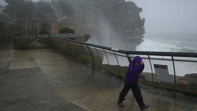
When the two weather systems finally broke down at the end of last year they were replaced by a new set of conditions that, though shorter lived, have swamped the east coast of the nation.
Monsoon rains finally moved south and a low-pressure system along the east coast brought rough seas and heavy falls.
The breakdown of the IOD and Antarctic systems was noted by the Bureau of Meteorology in its forecasts for the first quarter of the new year.
However, the BoM did not foresee in its seasonal forecasts the extent of what was to follow.
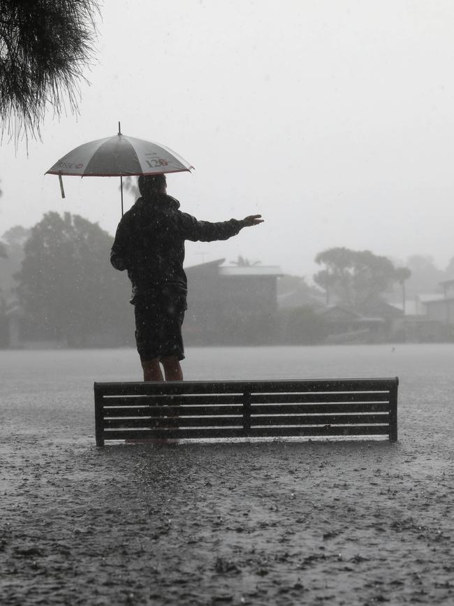
Soaking rains have drenched the east of the continent from Queensland to south of Sydney with downpours of hundreds of millimetres recorded, mainly along the coastline.
Big waves have again played havoc with beachfront areas.
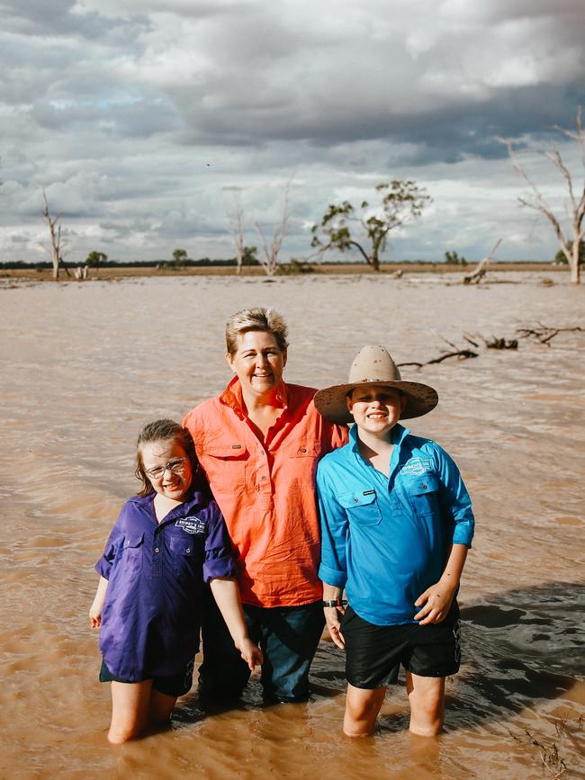
And for the first time in years, farmers have had something to celebrate. Several major rivers feeding the Murray-Darling Basin have started to flow, including the Condamine and Balonne in Queensland and the Namoi and Barwon in NSW.
Much of that water ultimately enters the Darling, which has not flowed solidly for years.
The Murray-Darling Basin Authority says, among other revivals, the Moonie River in Queensland is flowing for the first time since April 2018. Parts of the Weir, Macintyre and Dumaresq rivers of the Queensland-NSW Border Rivers region also are flowing, while in NSW water is passing through large sections of the Gwydir, Castlereagh and Macquarie catchments.
-
Row over irrigators
Already there is controversy, with conservation groups outraged at the NSW government’s decision to allow big irrigators to take millions of litres of flood water from the Barwon-Darling river system.
Inland Rivers Network spokesperson Bev Smiles says the flows are the “first ray of hope for the Darling River in years” and should be allowed to flow through the system to Menindee Lakes and the Lower Darling.
But the government has authorised irrigators to harvest the best part of the flows in Naomi, Gwydir and Barwon rivers, she says.
“This opportunity to revive the river system has been squandered at the behest of the powerful upstream irrigation lobby,” Smiles says.
Marine conservation groups are worried about the flush of ash and sediment through rivers and estuaries and into the sea.
The heaviest falls have been on the eastern side of the Great Dividing Range and will flow into the Pacific rather than inland.
And with a cyclone still brewing off the coast of Queensland the dramatic weather conditions are far from over.
Whether the drought has broken is an open question. Much will depend on follow-up rains.
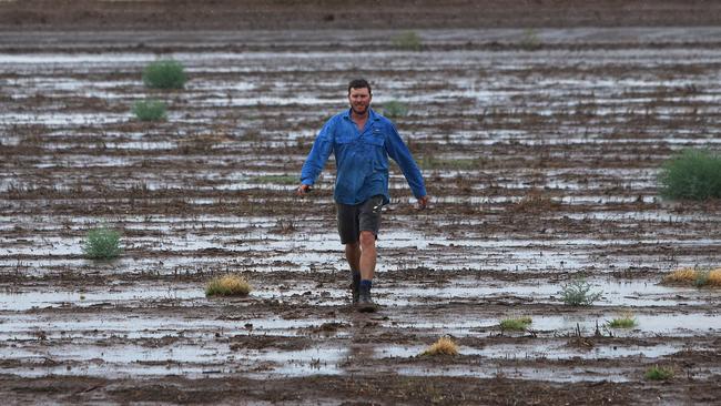
But National Farmers Federation chief executive Tony Mahar says this week’s rain has changed the fortunes of many farmers.
“As is often the case, some farmers have missed out. There are situations where a farm has received great rainfall while a neighbour has missed out,” Maher says.
To put the falls into perspective, Maher says communities on the Darling Downs in Queensland and in central and northern NSW have received almost as much rainfall in the past week as they did throughout the whole last year.
“Soil moisture profiles have been replenished and water supplies have begun to be refilled,” Maher says. “Importantly, the rain is a much-needed morale boost to the psyche of farmers and their communities.”
For many, the rainfall event turns the focus to recovery but it will be a long process.
“Many farmers have not had a viable crop for a number of seasons and livestock producers have significantly, if not entirely, destocked,” Maher says.
Drought-assistance measures from state and federal governments, such as the commonwealth’s Farm Household Allowance, will continue to play a role in helping families meet their everyday living expenses while they rebuild.
The NSW Farmers Association says rainfall does not mean money flows immediately for farmers.
“Rainfall has helped lift the spirits of some drought and bushfire-stricken farming communities in NSW, but the financial benefits will not flow for many months,” NSW Farmers president James Jackson says.
Nonetheless, many farmers have dusted off their gum boots, and good rainfall in the north of the state has filled dams and boosted soil moisture levels.
“It’s been a huge relief for many livestock producers who have been feeding out every day, and the psychological boost that this rain has provided is vitally important,” Jackson says. “It’s amazing what looking at green pastures can do for livestock and dairy farmers.”
As for income, Jackson says it is generally too late for summer crop prospects, but there may be some opportunities for late sorghum and maize forage crop plantings.
“Grain growers will be keeping a close eye on soil moisture profiles for winter cereal crops, so any real income generation is still many months away,” Jackson says.
“It has come at a critical time for horticulture producers on the north coast who had depleted water storages but, again, the money will not flow for up to two years for permanent plantings.”
-
Forecasting doubt
The BoM says it has provided consistent advice that sustained above-average rainfall will be needed to overturn the significant long-term rainfall deficiencies being experienced in many regions.
At the start of this week it said large areas of drought-affected regions had experienced average or below-average rainfall last month and this month.
“This follows years of below-average rainfall, which has left some communities in severe rainfall deficiency,” the BoM says.
“Despite the recent heavy rainfall along coastal areas, many areas of inland NSW affected by the drought have received far smaller rainfall totals.
“Like similar areas of Queensland, South Australia, Western Australia and the Northern Territory, they still require sustained above-average rainfall to address the serious and severe deficiencies being experienced.”
When things calm down it will be fair to ask if the BoM managed to miss what ultimately could mark the beginning of the end of what has been a prolonged and painful drought.
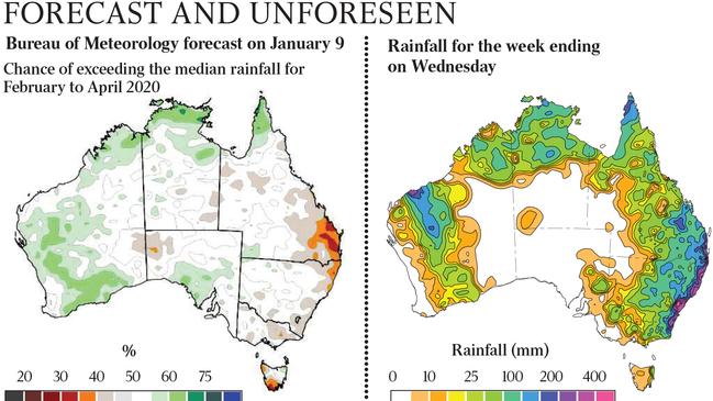
In its climate statement on January 9, spokesman Karl Braganza said “some of the key drivers of the recent warm and dry patterns over Australia have eased. As a result, rainfall for the coming months is expected to be average to below average in the east, while wetter than average conditions are possible (in) much of WA and SA.
“Unfortunately the outlook is not indicating a widespread return to wetter-than-average conditions over drought and fire-affected parts of eastern Australia.
“But with the likely return of the monsoon by mid-January for northern Australia, it raises the chances that we could see some periods of higher rainfall move south in the coming months.”
Asked about the forecast this week, the BoM says its models have predicted that the climate drivers behind the record dry conditions of last year are going to ease, resulting in more favourable conditions for rainfall in the first few months of this year.
“The bureau’s outlooks are probabilistic, showing the likelihood of above or below-average conditions over the coming weeks to months,” the BoM says.
“These long-term forecasts do not preclude the potential for individual significant weather events, such as the chance of heavy rainfall events which can occur across the east coast, particularly during the northern wet season.” It says probabilistic climate outlooks are different from the deterministic seven-day forecasts and warnings that support short-term decision-making and emergency response.
There has been heated debate over the BoM’s use of probabilistic models. The BoM says feedback about its long-range forecasts — on monthly and seasonal timescales — “indicated that customers sometimes had difficulty interpreting forecasts” and were looking for “higher demonstrated accuracy”.
In response, the bureau says it has undertaken a multi-year project to develop a world-class long-range forecast service. That has involved ditching the Predictive Ocean Atmosphere Model for Australia model the bureau spent many years developing and replacing it with a model from Britain’s Met Office and France known as ACCESS-S.
The bureau invested very significantly in POAMA from the early 1990s. POAMA was a general circulation model that attempted to simulate all the key ocean and atmospheric interactions. It did not become the actual operational model used for rainfall forecasting by the bureau until May 2013.
The new system acquired from the Met Office operates at a higher resolution than POAMA and is run on the bureau’s new supercomputer. Like POAMA it is a general circulation model.
However, some argue the bureau should include new methods such as artificial intelligence techniques to get better results. Probabilistic forecasts will indicate whether rainfall is more or less likely to be higher or lower than average. But there is little precision on what the outcome might be.
In May 2016 the bureau issued a three-month rainfall forecast for the Murray-Darling Basin indicating there was a 70-80 per cent chance of above-median rainfall for the period June to August.
Farmers were pleased at the prospect of good rains, only to experience record flooding — with crops washed away on many farms.
In short, the bureau’s probabilistic forecasts do not differentiate between rainfall exceeding the median by 1 per cent or exceeding the median by many times.
Forecasts are appraised as being equally correct.
-
Cloud over accuracy
In a letter to Simon Birmingham, the minister responsible for the BoM at the time, scientist Jennifer Marohasy said: “This, of course, provides an enormous range of actual outcomes where any given forecast can be regarded as ‘correct’ or successful from the perspective of the bureau.”
On the BoM’s more recent performance, Marohasy says it “could not bring itself to apologise for the wrong and totally misleading recent forecast” and this is “a reflection of the very sad state of affairs”.
“There needs to be some accountability. Australians deserve to know if the bureau has any capacity to provide skilful season rainfall forecasts or not,” she says.
The rains are of no surprise to timber worker Graham Walker from Victoria. He recalls battling the bushfires of February 1, 1969, in 45C heat as a 15-year-old.
“I bent all the linkage arms on the tractor ploughing fire breaks, experienced the extreme heat of the fire, the lack of oxygen in my lungs, being too scared to sleep inside the house at 2am,” Walker wrote. “Then the chaos came again a few weeks later when torrential rains caused massive erosion and polluted our water, and three months later on the 5th of May we had cows dying of bloat as the grass was so prolific!”
With weather, the next act is always just around the corner and still to come.
When the start of potentially drought-breaking rains finally came this month they were not predicted by the experts — but they should not have been a total surprise.