CSIRO will use hi-tech tracking of Australian feral animals from space
CSIRO has launched an ambitious hi-tech animal space-tracking program.
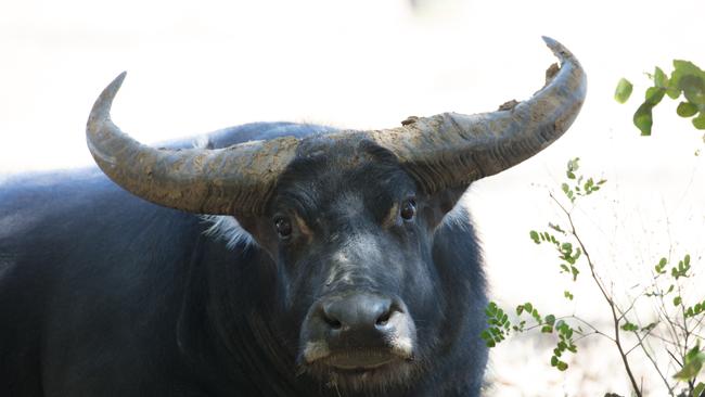
CSIRO has launched an ambitious hi-tech space-tracking program that will target more than 1000 feral buffalo and unmanaged cattle roaming Northern Australia.
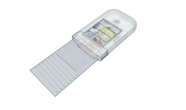
Satellite GPS-tracking tags will be attached to the animals’ ears and deliver real-time, geographically-accurate insights into herd density, accessibility, and transport costs.
It’s one of several efforts around the world to learn about the movement of animals and birds from space. Last year the International Space Station began tracking wildlife including birds in a joint German-Russian initiative called ICARUS (International Cooperation for Animal Research Using Space).
CSIRO says the animals will be tracked across a combined area of 22,314 square kilometres, taking in the Arafura swamp catchment in Arnhem Land in the Northern Territory, and Upper Normanby and Archer River on Cape York Peninsula in Queensland.
CSIRO says the $4 million, 3.5 year project aims to turn the destructive pests into economic, environmental and cultural opportunities for indigenous communities across the region, as well as create new ‘best practice’ for managing large herds using space technology.
CSIRO in a statements says CSIRO and Charles Darwin University will develop the data management tools, James Cook University will create the GPS-tracking ear tags and satellite company Kineis will provide access to their satellite fleet and technical expertise.
The North Australian Indigenous Land and Sea Management Alliance (NAILSMA) will drive efforts on the ground in partnership with Mimal Land Management Aboriginal Corporation, Aak Puul Ngangtam Ltd, and Normanby Land Management.
CSIRO says the project coincides with National Reconciliation Week this week.
Chief executive Dr Larry Marshall says the program demonstrates the opportunities for Australia in growing our own space capabilities and supply chains while also advancing reconciliation.
“Australia’s burgeoning space industry is creating exciting new possibilities for innovative science and technology to solve our greatest challenges, like using satellites to manage our wide, open land in more culturally and environmentally sensitive ways,” Dr Marshall said.
NAILSMA chief executive Ricky Archer says the program will create opportunities for economic development, landscape restoration and the protection of cultural sites.
“Using the information the ear tags generate, rangers and land managers can access more precise decision-making tools about where they focus efforts to reduce the impacts of buffalo and cattle grazing and eroding native flora and fauna,” Mr Archer said.
The project is being funded by Department of Agriculture, Water and the Environment under the National Landcare Program; Smart Farming Partnerships initiative.
Add your comment to this story

Trump’s smartphone can’t be made in America for $765 by August
Trump Mobile’s phone shows some specs that would beat Apple’s biggest, priciest iPhone models.

Start-up scores $68m for AI firefighters
An Australian-founded start-up has developed a new system that can spot a plume of smoke from 20km away and stop bush fires exploding into ‘mega’ infernos.
To join the conversation, please log in. Don't have an account? Register
Join the conversation, you are commenting as Logout