Victoria energy use to spike at over four times daily demand
Victorian energy use predicted to spike more than four times its usual daily demand as temperatures soar above 40 degrees
Victorian energy use is predicted to spike more than four times its usual daily demand to 9000 megawatts today as the state battles the first heat blast of the summer.
Victorian temperatures are expected to soar above 40 degrees in some parts of the state in a one-day scorcher in which temperatures in Melbourne are predicted to hit 37 degrees.
Energy demand will peak between 4pm and 5pm, according to the Australian Energy Market Operator, which says the hot weather will test energy supplies but will not cause a blackout.
AEMO has issued a Lack of Reserve 1 notice — its lowest grade warning — which advises that it could call on power producers to dial up energy output, but won’t resort to other energy saving measures including ordering large power users to power down.
“Based on current forecasts, we do not anticipate the need to call on this service this week,” an AEMO spokeswoman told The Australian.
“The forecast demand for Victoria on Wednesday is approximately 9000 MW due to high temperatures. Once the weather in Victoria cools down on Thursday, the demand is forecast to drop to 6157 MW.”
The spokeswoman from the market operator said it would soon release a full list of large-scale power users who had agreed to power down or scale back energy use during heatwaves and other events putting pressure on the state’s electricity grid.
The scheme — known as the Reliability and Emergency Reserve Trader — will also install more than 100 diesel generators into a disused power plant in the Latrobe Valley town of Morwell as another emergency backup source in the event of a major power outage.
The spokeswoman said the diesel generators will be operational in January, but it was possible they would never come into use.
“The procurement of diesel generation through the RERT process is to build on the Market’s reserves — and they may not be used at all,” she said.
The measures come as the state braces for a hot summer and possible energy shortages and price hikes following the closure of the Hazelwood coal-fired power plant, and a tightening supply of natural gas to the local market.
Energy, Environment and Climate Change Minister Lily D’Ambrosio said she was confident the state’s energy supply would hold up with the help of AEMO’s contingency plans.
“AEMO has advised that there is a sufficient amount of energy available within the grid, and are putting contingency measures in place to ensure that remains the case over summer,” she said.
Ms D’Ambrosio called the diesel generator plan an “insurance policy” that would help the state ride through heatwaves and other extreme weather events, while bringing down prices.
“AEMO’s plan adds to the work already being done by the Government to secure supply, bring new energy sources online and drive down electricity prices,” she said.
A week of heat
Heatwave conditions will affect most of the country this week, with temperatures reaching over 35c in many places.
NSW: Sydney will reach the high 30s in the West and 30C in the eastern suburbs, while Dubbo is expected to reach 37C and Richmond will exceed 35C in its highest December temperatures in over a decade. By tomorrow, Wester Sydney is expected to get to 41C.
Warm to hot mostly sunny #SydneyWeather today, reaching about 30C in the east and the high 30's in the west: https://t.co/kkm3TvyTlI and #beattheheat pic.twitter.com/JAwjCQC72i
— Bureau of Meteorology, New South Wales (@BOM_NSW) December 12, 2017
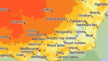
VICTORIA: Temperatures are expected to reach 37C in Melbourne today, before a cool change moves across the state later today
High temperatures across the state tomorrow, particularly in the north west. Keep hydrated 🚰 image from MetEye: https://t.co/ea3T4FJl7d pic.twitter.com/U5I8VSivPy
— Bureau of Meteorology, Victoria (@BOM_Vic) December 12, 2017
QUEENSLAND: Birdsville will experience the warmest temperatures with the mercury reaching 43C today and 43 on Thursday. Richmond will get up to 39C today and 41C on Thursday. Brisbane will e a relatively cool 30C today and 31C on Thursday.
However a severe storm warning has been issued for the northwest of the state.
A Severe #QldStorm Warning has been issued for damaging wind gusts over the northwest of the state. Monitor the radar at: https://t.co/de4xYr0ze5, and latest warnings: https://t.co/ZGbmnVf3Dy pic.twitter.com/dXRZLAXg6C
— Bureau of Meteorology, Queensland (@BOM_Qld) December 12, 2017
ACT: Canberra will reach 34C today and tomorrow.
View our latest #heatwave maps and forecasts at https://t.co/brSLHPLhJj. #NSWweather #ACTweather pic.twitter.com/NT2W8QR1lZ
— Bureau of Meteorology Australian Capital Territory (@BOM_ACT) December 11, 2017
SA: After hitting 36C yesterday, Adelaide will reach 38C today but a cool change will bring temperatures down to 24C on Thursday.
Hot to very hot on Wednesday for South Australia. https://t.co/hH4MMCTl9Y Keep an eye out for updated Fire Danger Ratings https://t.co/UPWgzflh6G pic.twitter.com/6Dn9c51cIJ
— Bureau of Meteorology, South Australia (@BOM_SA) December 11, 2017
WA: After suffering high temperatures all week, Perth will hit a relatively cool 27C today and go up to 29C on Thursday. However the BoM has issued a severe thunderstorm warning for southeastern parts of the state.
Severe Thunderstorm Warning issued for possible damaging winds, heavy rainfall and large hail for southeastern parts of #WA. pic.twitter.com/UTl6fdAlmA
— Bureau of Meteorology, Western Australia (@BOM_WA) December 12, 2017