‘Volatile’: Second Qld cyclone could form within week as insane mix of storms, floods, heatwaves forecast for Aussies
A second tropical cyclone could form off the east coast within a week as meteorologists warn a “volatile” mix of storms, floods and heatwaves.
Another tropical cyclone could form off the coast of Queensland within a week, adding to a volatile mix of flooding, heatwaves and storms forecast to hit millions of Aussies across the country.
A tropical low currently in the Coral Sea now has a 55 per cent chance of forming into a tropical cyclone from Sunday, the Bureau of Meteorology (BOM) on Tuesday announced.
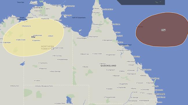
It is the state’s second tropical cyclone this storm season after ex-TC Jasper left a path of destruction in the Sunshine State’s north over December.
Rain-soaked regions had no time to recover as more storms plagued the state over January.
BOM Queensland on Tuesday tweeted the system was expected to remain offshore for the next seven days.
“However uncertainty in its movement increases from early next week,” it said.
The new cyclone warning is in addition to a current one in place for the Cocos (Keeling) Islands off the west coast of Australia, where Tropical Cyclone Anggrek has formed.
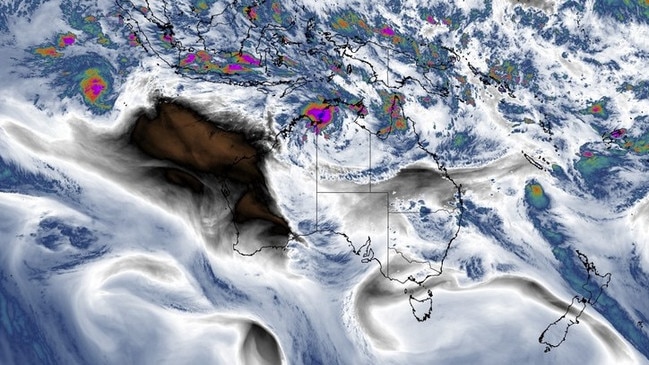
A BOM spokesperson said Anggrek is currently a category 1 cyclone and is located about 455km northwest of the remote territory.
It is likely to build to a category 2 system before moving to the south over Wednesday and Thursday.
“While there is large uncertainty in the movement of TC Anggrek on the weekend, it is currently forecast to start weakening by then,” the spokesperson said.
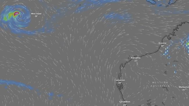
A monsoon trough – extending Top End of the Northern Territory to northern Queensland – dumped rainfall totals of more than 100mm in some areas over the past week.
Over the next week, those in eastern and northern parts of the country will have to contend with days of rain, largely thanks to a monsoon that’s settled in over the tropics, as well as moisture-rich air from the Coral and Tasman Seas.
While the majority of Australians will be contending with the deluge of rain, those in the west and centre will be sweating through heatwave conditions as a mass of hot air “lingers” over the area.
NSW
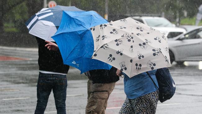
There’s still days worth of rain on the cards for NSW residents, with flash-flooding, hail and gusty winds all possible over the next week.
The state has already endured a deluge of water that fell on Monday, with over 100mm of rain soaking the ground in parts of Sydney.
North Parramatta recorded the highest rainfall for this storm event so far, with 152mm in the gauge between Sunday and Monday, followed by 147mm in Baulkham Hills and 125mm in Northmead.
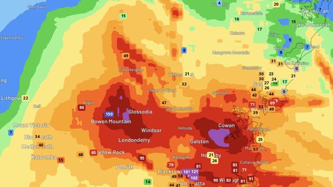
There are concerns that further rain will contribute to more flooding, with more than 30mm more expected to fall on the already-soaked ground.
“Rain and thunderstorms are also likely to develop over a broad area of southern and southeastern Australia between now and Thursday, mainly due to the passage of an upper-level low and associated trough,” Weatherzone meteorologist Ben Domensino said.
“This outbreak of wet and stormy should feature some severe thunderstorms and may cause pockets of flooding.”
Flood warnings remain in place for the Bellinger, Orara, Murray, Warrego and Paroo rivers.
Slow-moving severe and “very dangerous” thunderstorms are plaguing the Riverina district in the state’s west the Bureau of Meteorology warns.
Affecting Griffith and Hay, residents were warned heavy rainfall could lead to “dangerous and life-threatening flash flooding” on Tuesday.
QUEENSLAND
Persistent rain and storms will plague those in the north this week, according to Mr Domensino, “adding more water to already sodden catchments”.
Thanks to the monsoon sitting over Australia’s north, heavy rain is forecast until next Monday for the Cape York Peninsula and as far south as Townsville.
Cairns, which has been plagued by wet weather since it was hit by ex-Tropical Cyclone Jasper in December, is likely to receive 20mm a day for the rest of the week and into the weekend.
Flood warnings remain in place for the Paroo, Barcoo, Bulloo, Herbert, Murray, and Diamantina Rivers.
Most worrying to authorities is the Paroo River, with towns like Eulo and Hungerford urged to be on high alert as the flooding nears its peak.
The river is currently just shy of four metres at Eulo and rising.
Southeast Queensland won’t be out of the firing line for heavy rain, with Brisbane set to be drenched on Tuesday.
Up to 20mm of rain is expected to fall over the city, with showers to persist until next Monday.
NORTHERN TERRITORY
The heaviest rain will fall across the Top End and Kimberley, where the monsoon’s showers have forced the Bureau to issue severe weather warnings for locals.
The low will remain over land for most of the week, with the Bureau predicting it will drift eastwards and “deepen” over the next few days.
“Widespread heavy rainfall is likely to increase as the monsoon low strengthens,” BOM warned.
“Significant river, creek, and stream rises are likely with heavy rainfall, with possible minor to major flooding across the Flood Watch area during this week.”
Due to the weather, many roads will likely be affected and some communities may become isolated.
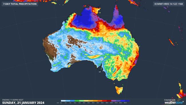
Metres worth of water has already fallen in the NT according to Mr Domensino, and there’s more to come.
“Some models predict well over half a metre of rain in parts of the NT this week, with accumulated totals over 1000mm not out of the question,” Mr Domensino said.
“Port Keats (Wadeye) received a whopping 334.8mm during the 24 hours to 9am on Monday, which was its 2nd heaviest daily rainfall on record.”
A severe weather warning is also in place for Daly, Twii, Gregory and parts of Arnhem, Carpentaria and Barkly districts.
“Monsoonal flow across the northern Top End is likely to increase further today. Heavy rainfall which may lead to flash flooding is likely over the Daly and far northern Gregory districts,” the Bureau warned.
“In the short term, the area most at risk remains in a band of storms north of Wadeye over the western Daly. Other parts of the warning area may see these conditions develop today, although heavy falls of this order are less likely north of about Adelaide River.”
Locations likely to be affected include Darwin, Katherine, Nhulunbuy, Palmerston, Jabiru, Maningrida, Wadeye, Wurrumiyanga and Nauiyu.
Darwin is receiving its share of the drenching, with up to 120mm likely to fall on Tuesday followed by 110mm on Wednesday.
WESTERN AUSTRALIA
While the east is underwater, residents in western parts of the company are going to be sweating through sweltering conditions thanks to a mass of hot air lingering over the area, thanks in part to the tropical low over the NT.
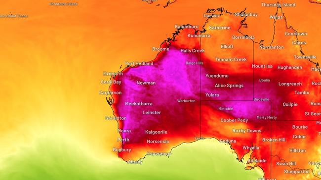
The majority of the state will continue through the low-intensity heatwave that has plagued it since the weekend, with temperatures to get as high as the mid-40s in WA’s north while the mercury will hover around 40C in the south, including Perth.
The state’s capital will reach its highest temperatures on Tuesday, around 41C in the middle of the day.
Southern parts of the state can expect conditions to ease from Wednesday when western airflows are expected to bring down temperatures.
That’s little help to those in the north, who will continue to sweat through til the end of the week, with some areas in the Pilbara likely to nudge 50C degrees.


To join the conversation, please log in. Don't have an account? Register
Join the conversation, you are commenting as Logout