‘Prepare now’: Tropical cyclone warning issued for popular tourist town
Residents have been warned to stay inside and secure their belongings as a tropical cyclone threatens to develop and smash the coast in the next 24-48 hours.
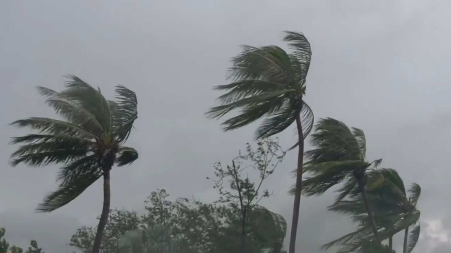
Residents in northern Western Australia have been warned of a tropical cyclone forming on the Kimberley coast, bringing intense rainfall, blistering gale-force winds and large waves within the next 24 hours.
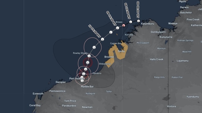
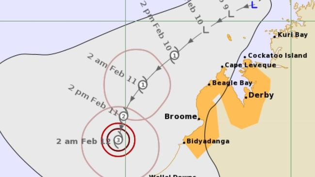
The Bureau of Meteorology issued a tropical cyclone watch for residents between Cockatoo Island to Bidyadanga, including the tourist town Broome, as tropical low 18U continues to form off the Kimberley coast.
Currently, 18U is 425km north-northeast of Broome and 130km north-northeast of Kuri Bay, and is expected to strengthen over the next 24-48 hours.
It is currently moving slowly in a south-westerly direction, and although the tropical low has not yet been classified as a tropical cyclone, as of 8am Sunday, it has a high chance (60 per cent) of becoming a tropical cyclone by Monday evening.
As the tropical low continues developing off the coast, it is likely to bring extreme conditions such as gale-force winds, heavy rainfall and large waves.
“In this watch area, we may see gales developing as early as Monday morning,” BOM senior meteorologist Miriam Bradbury said.
Rainfall is also likely to become more intense in the area from Sunday evening, with large waves also possible as winds pick up and increase in severity.
The bureau warned of winds exceeding 100km/h near the Kimberley coast, particularly hitting between Cockatoo Island and Beagle Bay before extending further towards Broome and Bidyadanga on Monday afternoon.
The bureau has also issued a flood watch for the West Kimberley coastal catchments from late Saturday into Sunday.
“Catchments across the flood watch area, particularly towards the coast, have become wet with recent rainfall,” the bureau website read.
Rainfall totals are forecast to reach between 30mm-60mm along the North Kimberley coastal catchments on Sunday, with pockets expected to see higher isolated rainfall totals.
“Forecast rainfall in the flood watch area is expected to result in river rises, areas of flooding and may adversely affect road conditions,” Ms Bradbury said.
“Roads may quickly become impassable and some communities may become isolated once that rain starts to fall.”
In the coming days, residents in northern WA can anticipate soggy and blistering conditions, as the tropical low strengthens.
The bureau expects 18U to develop into a tropical cyclone between Sunday evening and Monday morning.
“The system will move southwest off the Kimberley coast and continue to develop,” Ms Bradbury said.
From Tuesday to Thursday, the tropical low is likely to move southwest towards the Pilbara coast, and strengthening further as a tropical cyclone.
Despite the 60 per cent chance of the system developing in to a tropical cyclone, the bureau said there were “a number of different ways” the tropical low could develop over the coming hours.
“This would depend on how quickly the tropical 18U becomes a tropical cyclone, and how much energy it can tap into to sustain its cyclone strength,” Ms Bradbury said.
The bureau warned of abnormally high tides between Cape Leveque and Kuri Bay from Sunday evening, though the sea levels should not exceed the highest tide of the year.
The Department of Fire and Emergency Services (DFES) issued a warning to residents in the area on Sunday morning, urging them to “prepare now” as wild conditions begin ramping up across the Kimberley region.
“Get ready for dangerous weather by preparing your home inside and out,” a DFES statement read.
“Secure boats, caravans, trailers, garden sheds, outdoor furniture, rainwater tanks, LPG bottles, loose material and rubbish around your home and workplace.”

Blow to Aus as new bird flu outbreak found
Just days after Australia declared it had eradicated a highly contagious strain of bird flu, an outbreak has been detected in Victoria.
‘Major issue’: 10,000 Australian jobs at risk
The man behind a booming mining company in Indonesia has issued a stark warning about 10,000 Aussie jobs.