‘Too late to leave’: Extreme danger warnings in place around the country
Residents in some parts of regional Queensland have been urged to prepare to leave their properties.
Parts of the country are battling intense bushfires, as millions of Aussies are being warned to be on high alert following increasing temperatures and dry windy conditions.
Residents in parts of regional Queensland have been urged to prepare to leave their properties.
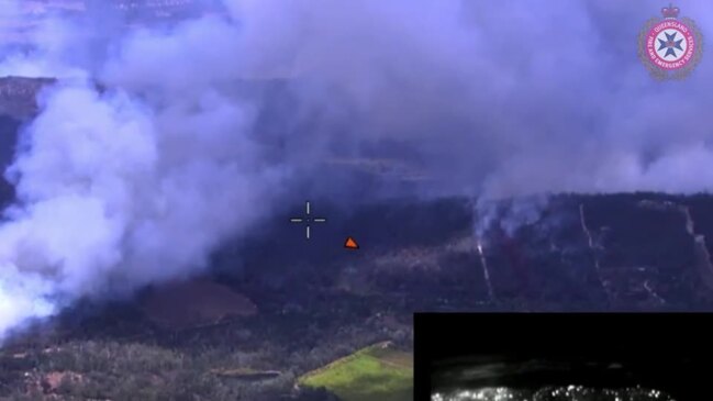
Queensland Fire and Emergency Services issued the Watch and Act warning for Hendon and Upper Wheatvale, 20km west of Warwick, and also for Cooktown in Far North Queensland on Sunday.
“Properties between Repeater Station Rd, Yankee Gully Rd, Quigley Rd and Upper Wheatvale Rd,” QFES warned.
PREPARE TO LEAVE - Hendon and Upper Wheatvale - fire as at 3:45pm Sunday, 22 October 2023.
— Qld Fire & Emergency (@QldFES) October 22, 2023
For all current warnings, updates and mapping go to https://t.co/vqyJTUPBhe. pic.twitter.com/Ckvrn8LyD8
“A large, fast-moving fire is burning at Yankee Gully Road, Hendon.
“It is travelling towards Lawler Rd and Upper Wheatvale Rd.
“Conditions could get worse quickly.
“Firefighters are working to control the fire. You should not expect a firefighter at your door.
“Firefighting aircraft are helping ground crews.”
Meanwhile, in the states north firefighters are working to control the blaze at Cooktown.
“Those properties between Cameron Creek Rd and Barretts Creek Rd including Kenny Rd and Rootsey Rd,” QFES stated on Sunday.
“A small, slow-moving fire is burning near Cameron Creek Rd. It is travelling towards Barretts Creek Rd.
“Conditions could get worse quickly.”
PREPARE TO LEAVE - Cameron Creek Road and Barretts Creek Road (Cooktown) - fire as at 2:19pm Sunday, 22 October 2023.
— Qld Fire & Emergency (@QldFES) October 22, 2023
For all current warnings, updates and mapping go to https://t.co/vqyJTUPBhe. pic.twitter.com/YiecDOGvtr
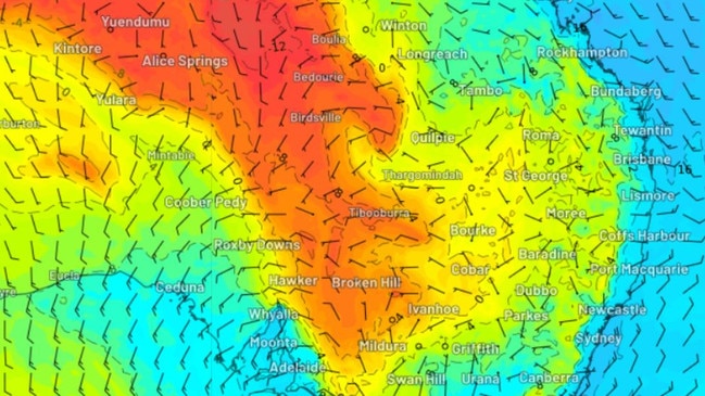
Extreme fire danger is also forecast for parts of NSW, WA and the NT on Sunday.
Residents in the vicinity of Segenhoe, NSW were being urged to seek shelter with an out of control bushfire raging in nearby Scone in the Upper Hunter region.
A 316 hectare fire is also causing concern in Bretti, 170km north of Newcastle, with residents urged to watch and act.
Emergency Warning: Barton St Fire, Scone
— NSW RFS (@NSWRFS) October 22, 2023
A fire is burning near Barton St, Scone, burning in an easterly direction towards Segenhoe. If you are in the vicinity of Segenhoe, you are in danger. Seek shelter as the fire approaches. It is too late to leave. https://t.co/hzJkTKus1Mpic.twitter.com/HStmhSP2U2
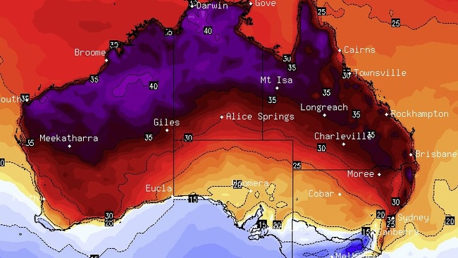
Further north, Mount Isa in Queensland could be set for record-breaking seasonal temperatures on Wednesday, Sky Weather reported.
Parts of the NT near Darwin are also sweltering through a severe heatwave.
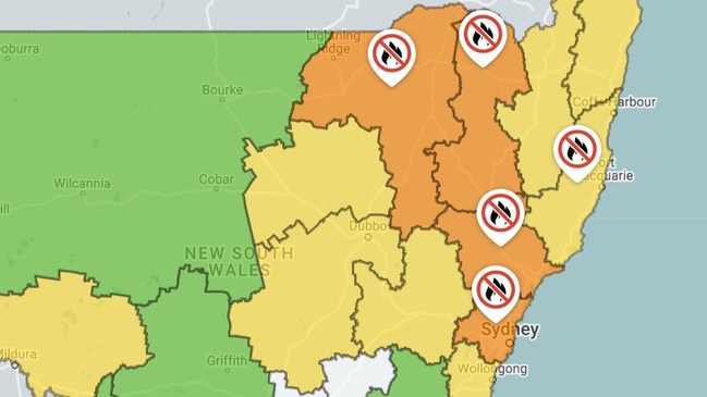
Total fire bans are in place for much of NSW including Greater Sydney and the Hunter Valley.
Residents in the Northern Rivers region of Grafton could sit through two bouts of 38C weather over Sunday and next Wednesday.
Temperatures across Queensland are also due to stick around in the mid-to-high 30s until midweek.
The air mass has continued to move eastwards over the weekend, with extreme fire danger forecast from northern NSW down to metropolitan Sydney on Sunday.
Firefighters across the country are once again on high alert after battling to control large, out-of-control fires in Kempsey, NSW and Bundaberg, Queensland last week.
As many parts of the country swelter, parts of the southeast are set to shiver later this week.
Snow is predicted to arrive in parts of Tasmania by midweek, with the Melbourne maximum temperature to drop as low as 15C on Wednesday and Thursday.
NSW
Temperatures are set to soar in many areas of NSW on Sunday. Extreme Fire Danger is forecast for the Greater Hunter, Greater Sydney Region, Northern Slopes and North Western fire districts.
Total fire bans are in place for much of the state, stretching from Sydney up to Coffs Harbour along the coast and as far as the QLD border further inland.
Warm, sunny weather will stick around until Monday, with Sydney’s worst heat – a high of 30C in the CBD – due to settle in on Sunday.
Hot, windy weather has fire crews on edge around the state.
In Grafton, in the Northern Rivers region, residents could experience uncomfortable heat of up to 38C on Sunday and again on Wednesday.
Total Fire Bans are now in place for the Greater Sydney, Greater Hunter, North Coast, North Western and Northern Slopes areas.
— NSW RFS (@NSWRFS) October 21, 2023
With hot, dry and windy conditions expected throughout today, extreme and high fire danger is forecast for large parts of NSW https://t.co/R9tDns8ts6pic.twitter.com/2w2hHug5c1
ACT
A mostly sunny day is expected in the nation’s capital on Sunday with a top of 19C.
The temperature will climb steadily at the start of next week, up to a top of 27C on Tuesday before dropping down to the low 20s for the rest of the week.
VICTORIA
Victorians are in for a cool, rainy Sunday with a low of 11C in Melbourne.
The state capital is expected to see a generally chilly week with daily temperatures predicted to max out at 15 degrees on Wednesday and Thursday before climbing slightly into next weekend.
Northern parts of the state, which saw sweltering conditions on Friday, have also been granted some relief, with a high of 22C in Mildura on Sunday and temperatures expected to stay in the low 20s for most of the week..
SA
A cloudy day is ahead of Adelaide residents, with a maximum of 18C on Sunday.
QUEENSLAND
The temperature in Brisbane will enter the mid-30s from Sunday, with the hot weather due to stick around until mid-next week.
In Ipswich, the temperature will climb up towards 35 to 37C next week.
Mount Isa and areas in the north west of the state could see temperatures pass the 40C mark, with a max of 41C forecast for Wednesday and Thursday.
TASMANIA
The southernmost state missed out on the hot, dry blast arriving over the rest of the southeast on Friday.
Hobart is expecting a day of rain on Sunday, with up to 10mm forecast and a high of 19C.
The rest of the week will be generally wet and chilly with snow forecast for Kunanyi/Mt Wellington near Hobart from Tuesday to Thursday.
WA
Perth is set for a sunny Sunday, with a high of 24C on Sunday.
The warm weather will stick around for the coming days but temperatures are unlikely to crack the 30s until midweek.
Extreme Fire Danger is forecast for the Mortlock district on Sunday.
NT
Darwin will be sweating through temperatures in the mid-30s from Sunday through to the end of next week. A heatwave warning is in place for parts of the NT.
An Extreme Fire Danger warning is in place for the Barkly North district

Proof you can own in Sydney for under $1m
Fresh government data has shined new hope on the great Australian dream, proving you can still buy a home in Sydney for under $1m.

Massive HECS change coming to home buyers
Treasurer Jim Chalmers said he is asking for a “commonsense” change that will allow help more Australians purchase their first home.