This was published 2 years ago
Extreme rain deluges intensifying over Sydney, study finds
Extreme and potentially dangerous bursts of rain have intensified by an “alarming” 40 per cent in Sydney over the past two decades, with climate researchers flagging major implications for how cities deal with flash-flooding and drainage.
Scientists at the ARC Centre of Excellence for Climate Extremes studied 20 years of weather data, including records from three Bureau of Meteorology radars near Sydney - Terrey Hills, Wollongong and Newcastle - to review sub-hourly rainfall during storms.

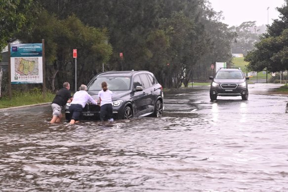
Flash flooding at Narrabeen in Sydney’s northern beaches during a heavy rain event in March 2022.Credit: Nick Moir
University of NSW Professor Jason Evans said the amount of rain falling in these extreme deluges was now generally between seven and 20 millimetres in 10 minutes, whereas 20 years ago, it was four to 15.
“It’s going up far faster than we imagined”, he said, despite there being little evidence of the same trends at hourly or daily scales. “The storm overall might not be producing a lot more rain, but it’s a lot more concentrated.”
The exact definition of a rapid rain burst varies depending on the area, but generally the term refers to the most extreme 5 per cent of rainfall in that location. The findings are published in the current issue of the academic journal Science.
Sydneysiders have endured flash-flooding all year as the city clocked up its wettest year on record. Evans said the trend his team observed was so strong that if it continues, “we’re going to see some really big issues in urban areas with flash-flooding type events”.

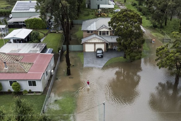
Flash flooding at properties in Shanes Park in Sydney’s west in March 2022.Credit: Brook Mitchell
“These aren’t the kind of events that are causing large-scale river flooding,” he said. “It’s the kind of event that overwhelms the gutters and the drainage systems, floods the road, floods the property really quickly.”
Evans said the reason for the bigger rain bursts wasn’t yet clear, though it was consistent with what was expected from climate change. The team has ruled out changes in radar sensors and the main forms of climate variability.
The study only took place in the Sydney area, as those three radars had the longest period of data - back to 1996 in the case of Wollongong. The team believes they will find the same phenomenon elsewhere - they plan to study Darwin and Melbourne next, where there are radars with suitable amounts of data. But “that’s not to say we think we’ll necessarily find it everywhere”, Evans said.
The study was led by Dr Hooman Ayat, now at the University of Melbourne, who described the intensification of rapid rain bursts as shocking and alarming.
“Previously, rain gauges, climate models and satellites have struggled to accurately identify rain bursts on such small-time scales,” he said. “However, our new data analysis technique was able to take historical weather radar data to get a much stronger picture.”
Professor Steve Sherwood, another member of the UNSW team, said the technique was now being used elsewhere around the world to make the most of radar data. “It’s a scientific mystery that we need more work on to understand better,” he said.
Some areas of Sydney are particularly susceptible to flash flooding, including low-lying parts of Marrickville and Wolli Creek along the Cooks River.
Evans said people ought to be prepared for more frequent flash-flooding, and the findings were cause to re-examine design standards for guttering and drainage.
The Morning Edition newsletter is our guide to the day’s most important and interesting stories, analysis and insights. Sign up here.