Much of Western Australia has a 60-80 per cent chance of below-average rainfall this spring, long-range forecasts released on Thursday show.
And despite an August much rainier than last year’s, a long-established overall decrease in WA rainfall since the mid-1970s continues, with the state experiencing up to 20 per cent less rainfall on average than 50 years ago.

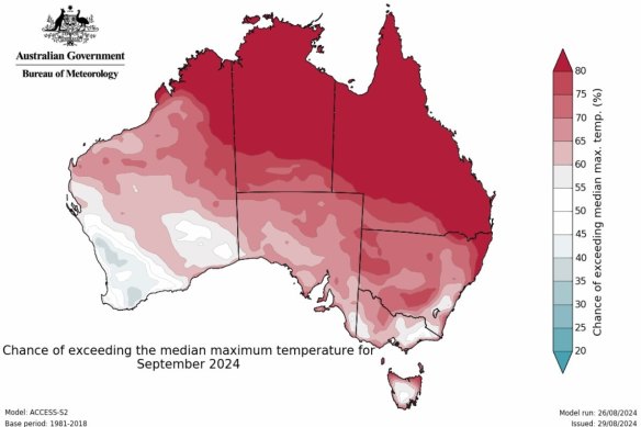
BOM’s spring long-range forecast has just been released. Credit: Bureau of Meteorology
Meanwhile, most of eastern Australia is looking at a high likelihood of above-average rainfall, the new Bureau of Meteorology forecasts show.
And while WA has a typical season forecast, a large portion of the northern and south-east of Australia is expecting above maximum average temperatures.
Bureau WA climatologist Yanhui Blockley said Perth and the south-west were likely to see temperatures in what was considered the typical range.
“In September, the typical temperature range for Perth is in the low 20Cs,” she said.
“As the days get longer in spring, the temperatures are expected to gradually increase.
“Towards the end of September, closer to October, we can expect the warmest temperatures to reach around 30C.”
The warmest temperature recorded in October was 37.2C, in 2013.
“[There are no] any strong indications of being much warmer or cooler than normal,” Blockley said.
“We base this on the Bureau of Meteorology’s climate forecast model to capture most climate influences, including long-term trends due to climate change and modes of inter-annual climate variability, such as the El Niño-Southern Oscillation and the Indian Ocean Dipole.”
In September, Perth usually receives 80 millimetres on average of rainfall, typically higher earlier in the month, tapering off as the month progresses.
For the start of next week, we’re expecting a cold front to bring some light rain to Perth, but then by the middle of the week, we’re expecting warmer days, with temperatures reaching the mid-to-high 20s Celsius, but it remains to be seen whether typical patterns play out beyond the seven-day forecast.
In 2023 Perth only got a maximum of 44.8 millimetres in contrast to the long-term average of 80 millimetres.
This month, 130.2 millimetres has been recorded, up from 75 millimetres in August 2023.
But despite the year-on-year variation, Blockley says the data continues to show a long-established decrease in rainfall since the mid-1970s.
“Over the past 50 years or so, we’ve seen about a 15-20 per cent decrease in rainfall, particularly during our main rainfall months in the south-west of WA,” she said.
“This drying trend is something that has been well documented.
“So while we had close to average rainfall in August across the south-west, and even slightly above average in some areas, when you look at the longer-term context, we’re still below the August average prior to the 1990s.”
BOM’s long-range forecast models use information from the physics of the oceans as well as millions of observations from satellites and instruments on land and at sea.
Read more
‘The shittiest time to be the MD of a company’: MinRes leader Chris Ellison
King plays down ‘hysteria’ over Pilbara unionisation, lashes BHP