Schools and shops to reopen, government to confirm hardship payments
By Cameron Atfield and William Davis
- Follow our live coverage for Cyclone Alfred here.
Schools across south-east Queensland will reopen on Monday where it is safe to do so, with heavy rainfall that caused flash flooding in low-lying parts of Brisbane on Sunday due to start easing.
“By 5pm today every school in the impacted area will have a status of open or closed,” Premier David Crisafulli said about 1.30pm on Sunday.
“Wherever possible, wherever it’s safe to do so, schools will be open.”
Greenslopes, Mansfield, Stones Corner, Tarragindi and Rosalie were among the Brisbane suburbs experiencing saturated creeks and flash flooding across roads on Sunday.
The Bureau of Meteorology forecast possible rainfall of 700 millimetres through to Monday, and the Queensland Police Service advised locals to stay off the roads and avoid unnecessary travel.

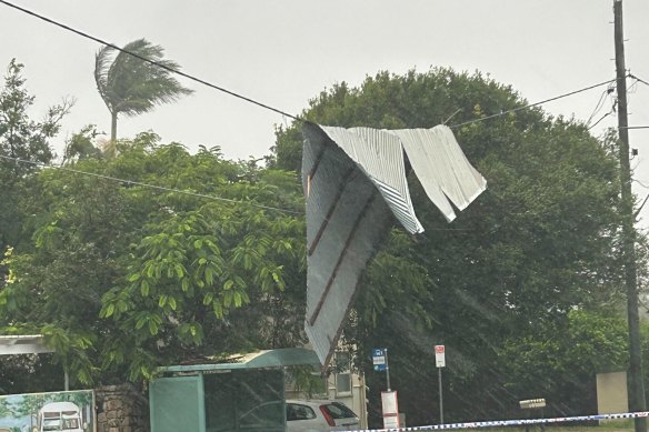
Gusts of more than 100km/h ripped off a roof in Redcliffe.
Heavy rain set in as 100km/h winds lashed the south-east corner on Saturday night, stripping roofs from houses in Redcliffe, uprooting trees across the city and bringing down powerlines.
More than 320,000 homes were without power across south-east Queensland on Sunday morning, including more than 50,000 in Brisbane. The worst-affected suburbs included The Gap, Rochedale, Acacia Ridge, Bald Hills, Carina, Everton Park, Ferny Grove, McDowall, Pallara and Wynnum West.
There were also 243,000 outages across the National Broadband Network with most of them in Queensland.

A piece of roof hanging over powerlines at Redcliffe.
In Hervey Bay more than 300 millimetres came down in about 27 hours from Saturday, causing some of the city’s worst flash flooding in recent history.
“There’s flash flooding right across … a lot of water in properties, more than 20 people rescued,” mayor George Seymour said.
“It’s been an extraordinary flash-flooding event ... I’ve never seen it like this in my 20 years in Hervey Bay.”
Insurers had received more than 3000 claims from residents in South East Queensland and northern NSW by Sunday afternoon.
The state government confirmed it was working with the federal government to provide hardship payments to Queenslanders impacted by the extreme weather.
“We’ll be outlining to eligible residents about those costs and what that covers,” Crisafulli said.
Many supermarkets reopened on Sunday morning, but some were almost entirely out of fresh fruit and vegetables. Woolworths on Montague Road in West End opened its doors, with just two pumpkins sitting on the shelves in the fresh food section.
Ex-tropical cyclone Alfred made landfall at 9pm on Saturday, hitting the coast between Brisbane and Maroochydore. It began moving as a tropical low from Queensland’s Bribie Island, across the coast and inland towards the state’s south-west on Sunday.
Forecasters expected heavy rain and destructive wind gusts to continue through to Monday.
“Today is all about the rainfall that’s likely to be experienced around south-east Queensland and far north-eastern NSW,” BoM senior meteorologist Dean Narramore said.
Isolated rainfall of up to 400 millimetres was expected on Sunday alone, with another trough from central Australia dragging the weather activity inland over northern NSW.
“By Wednesday, the weather system will finally shift all this wet weather to coastal parts of NSW and clearing mid to late week, while south-east Queensland should start to see conditions easing from persistent rainfall on Monday,” Narramore said.
The bureau’s Brisbane manager, Matthew Collopy, said a risk of life-threatening flooding remained across the region.
“As the remnants of the tropical cyclone move inland, we’ll see an in-feed of tropical moisture driving heavy to intense rainfall, and we’re expecting widespread totals of three to 500 millimetres, and event totals of up to 700 millimetres are possible through to Monday,” he said.
Seqwater began releasing water from North Pine Dam about 3am on Sunday, with engineers keeping watch on Somerset and Wivenhoe dams.
But there were signs of south-east Queensland slowly coming back to life after halting services for Alfred’s arrival.
Buses resumed on Sunday morning, but drivers were told to go home due to the heavy rain and flash flooding before midday. The government has confirmed some routes are due to restart on Monday.
“We’re very grateful for the way that those staff did that, to be able to allow some key workers to get to work,” Crisafulli said.
“Turning to tomorrow, [Brisbane] bus services will again operate but on a limited capacity.”
Moreton Bay ferries were due to resume on Sunday, while Brisbane and Gold Coast airports also reopened, with two international flights landing before 7am.
Brisbane Lord Mayor Adrian Schrinner said special red-top bin collections would occur on Sunday for residents who missed out on Thursday and Friday as Alfred approached.
“Council’s contractor has warned it may not be possible to complete every pick-up,” he said. “The special service will require 175,000 collections in a single day.”
Schrinner said bins not collected on Sunday would be collected on their regular collection day next week.
“Regular collections of all bins, including yellow and green bins, will restart on Monday,” he said.
Green waste drop-off remained free until further notice.
Meanwhile, two baby boys named “Alfie” were born in Brisbane on Friday. Mater Mothers’ Hospital general manager Kerri Gane said the boys were among 66 babies born at the facility over the past three days.
Get alerts on significant breaking news as happens. Sign up for our Breaking News Alert.