- Updated
- National
- NSW
- Extreme weather
‘Bomb cyclone’ stewing off coast, intensifying wind and rain
By Angus Dalton and Josefine Ganko
At least five million people have been lashed by severe weather generated by a “bomb cyclone” that has unleashed torrential rain, savage winds and waves of up to eight metres on the NSW coast, and the blitz of bad weather is expected to continue on Wednesday.
Residents along the coast from Forster to Bega were urged to heed a severe weather warning as the complex low-pressure system continues to lash the state with winds reaching 110km/h and heavy downpours. Some towns have already copped two months’ worth of rain in a day.

Wet and stormy weather is starting to impact the NSW coast.Credit: SMH
“It has been a very wild night for many parts of the east coast of NSW. And we are not out of the woods yet,” Platz told Nine’s Today. The agency has responded to 2000 incidents and Platz warned wind and rain would intensify on the South Coast.
By 6am on Wednesday, 242 millimetres of rain had hit Moreton over 21 hours, Ulladulla gauges clocked 223mm and about 200mm fell on Willinga Lake, Fitzroy Falls and Robertson. Winds faster than 100km/h battered the South Coast, Sydney Harbour and Penrith.
Residents of a handful of beachfront homes at The Entrance and Wamberal Beach on the Central Coast were ordered to evacuate on Tuesday afternoon as wild surf ate away at the coast.
The South Coast is on high alert for heavy rainfall that could lead to flash flooding, with up to 120mm of rain expected on Wednesday.
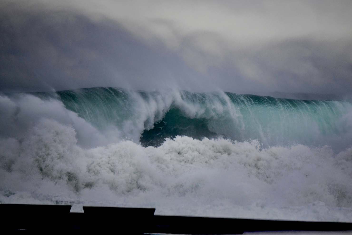
Huge surf battered the NSW coast on Tuesday.Credit: Dean Sewell
Emergency Services Minister Jihad Dib said the storm system spanned from the Mid North Coast to Bega, although communities such as Taree in the state’s north, still reeling from May’s flood disaster, were spared the worst of the heavy rain.
“Just the sheer size of it is quite enormous,” Dib said, warning that it was unlike the other recent storm systems that had battered NSW. “This one will be a much more intense and a much sharper system ... we’re asking people to be as prepared as they possibly can be.”
The system is stewing off the Illawarra coast and continuing to buffet it with severe weather.
“Through the later part of Wednesday, the coastal low-pressure system is forecast to gradually pull away from the New South Wales coast, moving north-eastwards, with the high-end severe weather impact starting to ease back into Thursday,” said the Bureau of Meteorology’s Helen Reid.

Fishers brave dangerous conditions in Newcastle as the fierce coastal low sets in.Credit: Dean Sewell
Authorities urged people to move their cars away from large trees as heavy rain hit saturated ground and fierce winds tore down branches and power lines, cutting power to 36,000 people across the Hunter, Central Coast and Sydney.
Most coastal catchments are on alert for minor to moderate riverine flooding, but flash flooding unleashed by possible downpours of 200mm pose the greatest threat on Wednesday, particularly on the South Coast.
What is a ‘bomb cyclone’?
Meteorological jargon used to describe the unusual low-pressure storm system has included “bomb cyclone”, “bombogenesis” and “explosive cyclogenesis”.
These terms all refer to the rapid intensification of the weather system. A dramatic plunge in pressure – about 20 to 30 hectopascals over the past day or two – quickly transformed the low into a severe storm system. Regions of low pressure in the atmosphere funnel air upwards, which triggers the development of storm clouds and powerful winds.
The system the bureau called a “vigorous coastal low” spiralled down the coast while generating storm-force offshore winds comparable to a category two cyclone, adjunct professor of environmental geography at CQUniversity Steve Turton said.
“That’s certainly going to increase the wave energy and the swells and so on coming onto the coast. We’re looking at over 5 million people likely to be affected by this system,” he said.
Abnormally warm water off the NSW coast helped fuel the rapid intensification, Turton said. Warmer oceans turbocharge storm energy and supply weather systems with moisture for heavy rain.

Warm water stretching down the East Australian Current on Tuesday was one of the ingredients behind the state-spanning weather system.Credit: Bureau of Meteorology
A region of ocean water brewing 1 to 3 degrees above the long-term average also contributed to Tropical Cyclone Alfred and May’s flood disaster, Turton said.
“That pool of warm water off the coast will certainly be providing additional energy into this system and increasing the risk for more rapid intensification and flash flooding,” he said.
About 90 per cent of the Earth’s extra heat caused by the burning of fossil fuels is trapped within the ocean, he noted.
NSW East Coast weather warnings
A severe weather warning for damaging winds was in place for parts of the Mid North Coast, the Hunter, Sydney, the Illawarra, South Coast, Southern Tablelands, Snowy Mountains, Canberra, Northern Tablelands, Northern Rivers and South West Slopes as of 4am Wednesday.
Rock fishers, boaters and swimmers were urged to stay away from the ocean under a hazardous surf warning in place from the Port Macquarie down to Eden. A damaging surf warning is in place from Forster to the NSW-Victoria border, where coastal erosion and damage to infrastructure is expected.
Southern parts of the Mid North Coast, the Hunter, Sydney-Illawarra Coast and Snowy catchments were under flood watch for minor flooding, while moderate flooding was possible for the Hawkesbury-Neapean.
Stay up to date with warnings here or on the Hazards Near Me app.
Public transport warnings and flight cancellations
Transport for NSW advised against non-essential travel on Wednesday morning.
Meanwhile, motorists are also being urged to prepare for delays and disruptions as the extreme weather continues, and to be vigilant for debris that may have fallen on roads.
“If you must travel, please allow plenty of extra travel to get to your destination. Be prepared for disruptions, including possible road closures and public transport delays,” a Transport for NSW statement read.

Delayed aircraft line up to take off at Sydney Airport on Tuesday.Credit: Wolter Peeters
A number of low-lying roads were closed in the Shoalhaven area on the state’s South Coast, which had received high amounts of rain overnight, he said.
Nearly 100 flights departing Sydney have been either cancelled or delayed, as Sydney Airport faces another day of chaos.
A social media video on Tuesday showed long lines at the airport, and we could see a similar situation on Wednesday, with 49 departing flights cancelled, and a further 47 delayed.
Power outages
About 30,000 households remained without power around the stateon Wednesday morning, as crews continue to work to restore power to customers.
On the Ausgrid network, which covers Sydney’s eastern suburbs and much of the Central Coast, more than 10,500 customers remain without power.

Ausgrid network power outages on Wednesday morning.Credit: Ausgrid
About 1000 of those households are in Sydney, with the rest on the Hunter and Central Coast.
In a statement, an Ausgrid spokesperson said crews had worked in difficult conditions through the night to reconnect customers.
The Endeavour network, which covers Sydney’s western suburbs, Wollongong and much of the South Coast, has more than 20,000 households without power.
There are still 184 active outages. At its peak, there were more than 300 hazards requiring repairs.
Start the day with a summary of the day’s most important and interesting stories, analysis and insights. Sign up for our Morning Edition newsletter.