This was published 1 year ago
NSW heatwave warning: Temperatures set to hit 40s
By Jessica McSweeney and Laura Chung
As global weather records continue to be set, a severe heatwave is forecast for most of NSW with temperatures set to soar into the 40s this weekend, bringing with it a heightened bushfire risk.
In Sydney, temperatures will start to climb on Thursday with 29 degrees expected in the city and 35 in the west.

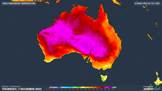
The first heatwave of summer will affect huge parts of the country this week, having already warmed up parts of WA over the weekend.Credit: Weatherzone.com.au
The heat will continue to rise to 31 in the city and 35 in the west on Friday, peaking on Saturday with a sweltering 35 in the city and 42 in Penrith.
The warm weather comes as this year will most likely be the hottest in 125,000 years. Since June, every month has been the hottest on record.
November was the warmest on record globally, with surface air temperatures of 14.22 degrees, 0.32 degrees warmer than the previous November record set in 2020, new data from the European Union’s Copernicus Climate Change Service, released on Wednesday, shows.
The first 11 months of this year have been the highest global mean temperature on record, 0.13 degrees higher than the 11-month average for 2016 – the warmest year on record.
Deputy director of the Copernicus Climate Change Service Samantha Burgess said this year had been one of records and would be the warmest on record.
“2023 has now had six record-breaking months and two record-breaking seasons. The extraordinary global November temperatures, including two days warmer than 2 degrees above pre-industrial [levels], mean that 2023 is the warmest year in recorded history.”
Director of the agency Carlo Buontempo added that, as long as greenhouse gases were increased, the alarming results would continue.
“The temperature will keep rising and so will the impacts of heatwaves and droughts. Reaching net zero as soon as possible is an effective way to manage our climate risks,” he said.

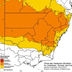
A Bureau of Meteorology heatwave map shows most of NSW impacted.Credit: Bureau of Meteorology
The new data was released during the middle of the COP28 summit, the annual United Nations climate meeting, where governments will discuss how to limit and prepare for future climate change as well as what progress has been made to reduce emissions since the 2015 Paris Agreement.
In Sydney, the UV index, which measures harmful radiation from the sun, is expected to reach 11 on Saturday. This is considered an extreme level and means unprotected sun exposure for 10 minutes can lead to painful sunburn.
The heatwave will first move across western NSW towards the east coast, with Bourke forecast to hit 44 on Thursday, Friday and Saturday. Cobar will see temperatures in the low 40s.
Extreme heat is one of the biggest causes of admissions to hospital in Australia, accounting for 7104 injury hospitalisations and 293 deaths in the 10 years to 2022.
NSW Health’s Dr Jeremy McAnulty urged people to take extra care to prevent heat-related illness.
“Hot weather puts a lot of strain on the body, including dehydration, and can make underlying health conditions worse,” he said.
McAnulty advised people to avoid being outside during the hottest part of the day, to keep cool using air-conditioning and fans, or to seek out cool public facilities such as libraries, and to stay well hydrated.
The heat started to build last week in Western Australia with a low-pressure trough dragging the warm weather down from the tropics, Bureau of Meteorology senior meteorologist Miriam Bradbury said.
The heat is made stronger by two high-pressure systems, with little relief in sight.
“The cold front is too far south and won’t penetrate the mainland, so it will struggle to bring any cool air across the continent,” Bradbury said.
“We are waiting for a stronger cold front to come through and sweep away that heat … but we are not going to see a huge shift from hot to cool conditions, more a gradual easing.”
Those hoping forecast showers on Sunday might bring a reprieve in western Sydney will be sorely disappointed.
While showers are forecast on Sunday, they will provide very little relief, with temperatures set to climb back into the mid-30s into next week.
Sydneysiders urged to stay indoors
While the temptation to cool down at the beach will be strong, NSW Health is urging Sydneysiders to stay indoors, particularly in the hottest part of the day.
“Heatwaves can be dangerous for everyone’s health, but some people are more vulnerable including people over 65 years old, babies and young children, people with certain medical conditions, people who work outside, pregnant women, people who live alone or are socially isolated and people who are homeless,” a statement from NSW Health said.
Authorities are also asking people to keep their exercise to the coolest part of the morning and seek out well air-conditioned public areas if they can’t keep their own homes cool.
The fire risk will increase towards the end of the week, with heatwaves and north-westerly winds elevating the danger to extreme on Friday in the northern Riverina and South Western districts.
On Saturday, the Lower Central West Plains and Southern Slopes will also see extreme fire danger.
NSW Rural Fire Service volunteers are being primed to jump into action this week, and the number of fire trucks deployed to fires will be doubled in areas of concern, Commissioner Rob Rogers said.
“The only good thing is we have had a fair bit of rain,” he said. “That calmed things down for a bit but that doesn’t mean we won’t have fires,” he said.
“I think we will have fires, but I’m hoping it won’t be as bad as it was. Before the rain we were getting 100 to 150 fires a day. I’m really hoping this hot weather doesn’t take us back to that point again. It has the potential to really dry out the landscape again.”
“I would have been happy to be proven wrong. Unfortunately, you have to plan, and I’m very grateful we did.”
Start the day with a summary of the day’s most important and interesting stories, analysis and insights. Sign up for our Morning Edition newsletter.