Here comes winter … and more rain
By Caitlin Fitzsimmons and Bianca Hall
A deluge will hit the east coast of Australia to kick off winter after autumn rains drenched most of the country, but left much of Victoria and other southern states drier than usual.
The prediction comes amid record temperatures globally — 2024 is tracking to topple 2023 as the hottest year.

Surfers enjoying the sunset in Byron Bay before the forecast weather change.Credit: Danielle Smith
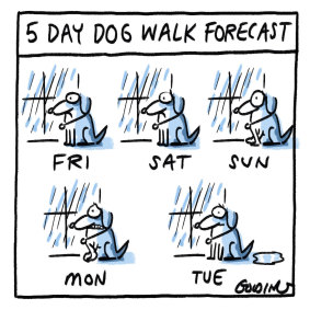
In NSW and Victoria, rain is forecast to set in on Friday and intensify over the weekend. While some are calling it a “rain bomb”, it’s not yet clear if it will be extremely wet or just rather wet.
Weatherzone meteorologist Ben Domensino said a “north-west cloud band” caused by moisture from the Indian Ocean was moving across Australia from north-west to south-east, bringing rain.
“On the weekend, there’s potential for some heavier rain as a low-pressure system develops offshore,” Domensino said.
“Where that low-pressure system is located will determine where the heaviest rain is and the strongest wind and the largest waves.”
If it forms as an east coast low, it will sit just off the east coast and cause high-impact severe weather on the land. If it forms as a Tasman low, then the worst weather will be out to sea, though the coast will still experience rain and high swells.
Domensino said the east coast would be rainy as far north as southern Queensland, but the warning about severe weather from the low-pressure system was for further south, either NSW or East Gippsland and Tasmania.
Scientia professor Matthew England, a climate scientist at the University of NSW, said May would be the 14th consecutive month of record-breaking ocean temperatures.
England said climate scientists knew the planet would be hotter this year than in 2023 because the Australian 2023-2024 summer was an El Nino year, despite also being rainier than usual.

Flash flooding in Melbourne in early April.Credit: Paul Rovere
Global annual heat records were shattered last year. The European Union-backed agency, Copernicus, reporting average temperatures 1.48 degrees above pre-industrial times. In India this week, a construction worker died from heatstroke after the temperature in Delhi topped 50 degrees amid a prolonged heatwave.
After an El Nino event, which usually brings hotter weather, the warmth in the Pacific Ocean is discharged globally.
England said the higher ocean temperatures were behind the rain and humidity because warmer water meant more evaporation into the atmosphere.
“We’re making the atmosphere more humid, more moisture-laden because as we’ve warmed the planet ... the amount of moisture the atmosphere can hold goes up,” he said.
England said the moisture content of the air, also known as specific humidity, went up by 7 per cent for every degree Celsius of warming. As water vapour was a greenhouse gas in its own right, this also raised the prospect of feedback loops.
Looking ahead to winter, the Bureau of Meteorology predicts mild temperatures, with uncertain rainfall.
The long-range forecast shows above-average rainfall is likely for some southern central and western parts of Australia, including north-western NSW. Elsewhere, rainfall is likely to be more typical for the season.
The forecast is for a high likelihood of temperatures that are higher than usual for this time of year across the continent.
The bureau said autumn had been warmer than usual for much of Australia, with the mean temperature about 0.5 degrees above the 1961–1990 average. All states and territories except the Northern Territory recorded above-average mean temperatures for the season.
National rainfall for autumn was 26 per cent above the 1961-1990 average, although it was below average in south-west Western Australia and parts of Victoria, Tasmania and South Australia.
At Sydney Observatory Hill, after a dry March, an estimated 315 millimetres of rain fell in April. This is about four times the long-term average for April, but does not exceed the deluge of 2022.
In the first 30 days of May, Observatory Hill recorded 219 millimetres, which is 1.9 times the long-term average of 118 millimetres.
Victoria was drier than average in autumn, but had days of heavy rain, and some specific sites across the state recorded the highest rainfall in 20 years.

Credit: Matt Golding
England and Domensino both said there were early signs that a La Nina pattern, which usually brings cooler weather, could form for the 2024-2025 summer. The El Nino-Southern Oscillation is currently in its neutral phase, typical for this time of year.
If a La Nina forms, England said 2025 would probably be cooler globally. As a measure, the atmospheric and ocean warming was clearly increasing, but it did not progress steadily from one year to the next.
“This distraction with El Nino sometimes gets people to be fixated on the year-to-year bumps,” he said.
“The problem with that is we’re still seeing ongoing warming of the subsurface ocean, ongoing ice melt. Climate change is measured by a whole bunch of metrics.”
Get to the heart of what’s happening with climate change and the environment. Sign up for our fortnightly Environment newsletter.