‘Pretty gnarly’: Hail, thunderstorms thumping southern Queensland
The Bureau of Meteorology says ‘very dangerous’ thunderstorms are hitting southeastern Queensland, with hail the size of golf balls falling in some areas.

Environment
Don't miss out on the headlines from Environment. Followed categories will be added to My News.
‘Gnarly’ storms are dumping golf-ball sized hail on numerous parts of southern and southeastern Queensland.
Bureau of Meteorology Angus Hines said about 5.30pm on Wednesday that “these storms are still pretty gnarly weather systems and still moving over large parts of eastern Australia”.
“We’re in the midst of quite a significant storm outbreak right at the moment,” he told ABC radio.
Since midday Wednesday, multiple thunderstorms across eastern and southeast Queensland, and eastern NSW, have developed and strengthened into severe thunderstorms.

Four separate storms, which the bureau deems “very dangerous”, were hovering over the Toowoomba, Southern Downs and Scenic Rim regions.
Large hail, strong wind and heavy rain are being felt on the ground.
“The key message is it’s not finished yet,” Mr Hines.
“Over the next several hours through this afternoon into this evening we still expect these storms to continue to develop and move across eastern parts of the country.”
The storms could potentially affect the highly populated parts of southeast Queensland and eastern NSW as well.
“So just because you haven’t seen a storm yet in the last few hours, it doesn’t mean the risk has eased because these storms are still pretty gnarly weather systems and still moving over large parts of eastern Australia.”
Numerous places have recorded between 20 and 40mm of rain in less than a one-hour window.
“That is certainly enough to lead to localised areas of flash flooding,” Mr Hines said.
Hailstones three to four centimetres in diameter have fallen in Queensland and NSW.
Wind gusts have been recorded at 70 to 90km/h, which is “near damaging”, but those speeds could elevate this evening.
There are also thunderstorms near the south coast of NSW, Illawarra and the southern and central Tablelands as well as further north toward those Queensland storms.
Bathurst and Parkes in particular have copped strong winds.
“We’re really into the thick of it now. Late spring and early summer … that’s the prime time for stormy weather across eastern Australia.”
Millions of Aussies were warned to brace for widespread thunderstorms.
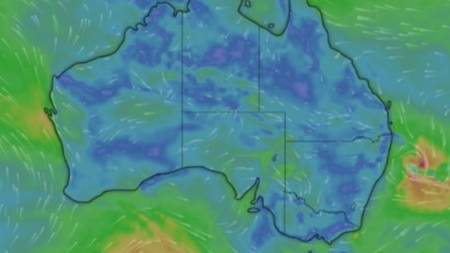
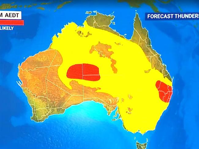
The Bureau of Meteorology earlier forecast that most of the country would experience thunderstorms on Wednesday.
“Couple of areas could see some widespread stormy outbreaks, firstly here on the east coast stretching from southeast Queensland down to eastern Victoria through Wednesday afternoon and evening,” Mr Hines said.
“We could also see some storms develop through inland and northern parts of Western Australia.”

However, Mr Hines said Queensland would be the hardest hit, with thunderstorms forecast for most of the southeast on Wednesday.
He said the Sunshine State is forecast to get “a potentially damaging and dangerous system” developing across the southeast across Wednesday afternoon.
“(The storms are) starting on the coast, just south of Bundaberg, around Maryborough, up to inland spots like Roma and Charleville, down to the southern border and to the south east coast as well,” Mr Hines said.
“That includes the likes of Brisbane, Gold Coast, Surfers (Paradise) and Sunshine Coast all could see severe thunderstorms.
“There’s even the potential for 5cm hail and destructive wind gusts right down near the NSW border.
“If you’re in this part of the country tomorrow, keep your head screwed on and stay up to date with the latest.”
More ⛈ï¸thunderstorm activity possible on Wednesday across #Qld. Severe storms possible in the south east of the state.
— Bureau of Meteorology, Queensland (@BOM_Qld) November 12, 2024
Watch out for warnings: https://t.co/FBmpsIoqYWpic.twitter.com/XzRcocRtXe
Meanwhile, NSW could see storms develop from the Queensland border to the Victorian border across Wednesday.
“The severe storms, the damaging wind, the heavy wind, the large hail will likely be north of Newcastle, the Northern Rivers slopes and plains and in the mid north coast,” Mr Hines said.
Victoria is forecast to see showers on Wednesday morning, except in the northwest where it was expected to remain sunny.
Meanwhile, South Australia will remain mostly dry but is forecast to record temperatures below average.
Earlier, Sky News Weather meteorologist Rob Sharpe said severe storms were expected to affect large parts of the country on Tuesday.
“Looking across today, you can see storms (are) a chance across pretty much half the country, so this afternoon we’ll see the stormy weather ramp up again, particularly across Victoria, NSW and southern Queensland and Central Australia,” Mr Sharpe said.
He said severe storms would mostly target northeast NSW and South East Queensland, with heavy rain “the main threat”.
“But I don’t think it’s going to be as heavy as what we saw (Monday) night, so totals may be up to 80mm rather than up to 150, which is what we saw on the Border Ranges (on Monday night),” he said.

There’s also a chance of storms between Alice Springs and Brisbane, and in Sydney, Canberra and Melbourne on Tuesday, with a cold front moving in on Wednesday.
“There will be a little cold front that will come up and across Tasmania, aiding showers there,” Mr Sharpe said.
“But storms will target eastern Victoria, NSW and eastern Queensland, with again, severe storms primarily near the border of NSW and Queensland.
“Looking further ahead and the storms look like remaining a chance right across the week. It will ease back a touch for the east over Thursday and Friday, but it will pick up again as a front runs across the Great Australian Bight and crosses southeastern Australia on the weekend with another big band of rain and storms, primarily on Sunday for the southeast of the country.”
Mr Sharpe also warned that there was “plenty of wet weather to go around” over the next seven days, with rain forecast for about 80 per cent of the country and some places to receive as much as 100mm.
Sydney is tipped to reach a high of 26C this week with possible showers right through to the weekend.
Melbourne is set to hit 32C on Saturday, while Brisbane’s high of 32C is expected on Thursday.
Perth is expected to reach 31C on Wednesday, with Adelaide set to hit 36C on Saturday.
Hobart is set for a top of 27C on Sunday despite a chance of showers, while Canberra is expected to reach 28C on Sunday with a chance of showers.
Darwin is expected to range between 34C and 36C over the week; however, possible showers and storms are anticipated.
Originally published as ‘Pretty gnarly’: Hail, thunderstorms thumping southern Queensland


