
Tropical Cyclone Alfred to hit Moreton Island first before weakening, reaching mainland
These residents are going to be hit first - and the hardest - by Tropical Cyclone Alfred as it approaches the coast, the latest forecast shows.
Environment
Don't miss out on the headlines from Environment. Followed categories will be added to My News.
The latest forecasts for Tropical Cyclone Alfred have put Moreton Island squarely in the firing line, with the small island expected to face the worst of the system’s wild conditions.
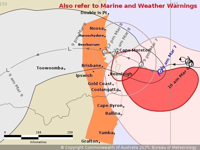
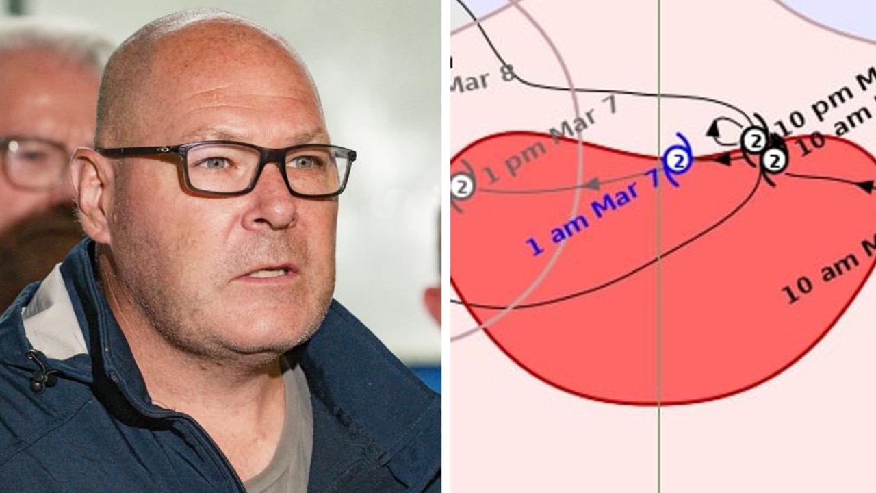
The Bureau of Meteorology projects the eye of the cyclone will pass Moreton Island - 50km northeast of Brisbane - early Saturday, before the slow-moving system hits the mainland about 10am.
Moreton Island is likely to feel the effects of a category 2 cyclone, before it weakens to category 1 and crosses the mainland between Noosa and Beenleigh.
The Bureau is putting out hourly updates on the cyclone.
In the latest posting, the weather agency says the cyclone will weaken further on Saturday.
“Heavy rainfall bands are continuing to extend over southeast Queensland and northeast NSW coastal areas,” the update says.
“Heavy to locally intense rainfall which may lead to dangerous and life-threatening flash flooding may develop from this afternoon. Once Alfred crosses the coast, it is likely to weaken below tropical cyclone strength during Saturday.”
Residents in parts of northern NSW are being warned they could face almost a week of heavy rain and flooding as Tropical Cyclone Alfred nears the coast.
The category 2 system was 195km east of Brisbane and 180km east-northeast of the Gold Coast as of the Bureau of Meteorology’s update at 6am (AEDT).
Senior forecaster Christie Johnson said on Friday morning Alfred’s impact would be felt “well and truly before it makes landfall”.
“It looks like it will initially make landfall on Moreton Island in the very early hours of (Saturday), or close to midnight, and then move across the mainland coast through the early hours of tomorrow,” she told the ABC.
“It’ll be those sort of conditions that we’re used to seeing for 20 minutes or so at a time with a thunderstorm coming through … but potentially sustained for six hours or more.”
As the current forecasts have the cyclone making landfall at Moreton Island - 50km northeast of Brisbane - the Brisbane City Council has released detailed flood maps. Multiple tributaries and offshoots of the Brisbane River are expected to burst, the maps show. The suburbs of Carina and Kalinga are expected to be particularly inundated.
NSW Premier Chris Minns said 2000 SES crew members were already positioned in the Northern Rivers region.
He said authorities originally believed the weather would last for about two-and-a-half days.
“Part of the problem we’re facing at the moment is that the weather window has gone from two (or) three days to five to six days, which means whilst the cyclone might slow down, the weather pattern, and in particular the rain, is extending,” Mr Minns said.
“Which means that we see 150mm to 300mm of rain a day, over multiple days, and that’s what we really worry about when it comes to flooding.”
Wild weather sets in as Alfred draws near
People in multiple areas of northern NSW have been ordered to leave their homes as the threat of flooding on the southern edge of the cyclone looms large.
Queensland residents directly in line with the cyclone’s projected path have been told to shelter immediately.
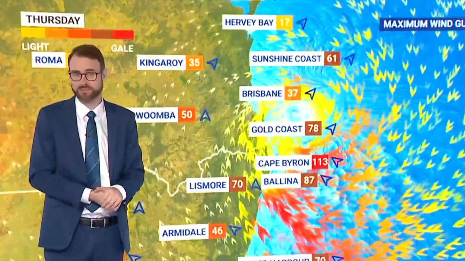
Tens of thousands of homes and businesses are without power and wind gusts in excess of 100km/h have already been recorded as the system bears down on southeast Queensland and northern NSW.
Areas around Byron Bay have recorded wind gusts over 100km/h in the early hours of Friday.
More than 26,000 homes and businesses lost power in southeast Queensland on Thursday night and Friday morning as the wild conditions set in.
The Gold Coast suburbs of Coolangatta and Mudgeeraba bore the brunt.
Tropical Cyclone Alfred, a category 2 system, continues to move slowly towards the southeast #Qld coast
— Bureau of Meteorology, Australia (@BOM_au) March 6, 2025
It is expected to cross the coast late Friday evening or early Saturday, most likely close to Moreton Bay between Noosa & Coolangatta
Latest: https://t.co/jlOoTZL1iF. pic.twitter.com/tFBSlAHb7U
Across the border, Energex is reporting similar outage numbers for northeast NSW.
Fallen power lines and debris have knocked out power for thousands of people.
Rain gauges have already begun filling up, possibly foreshadowing what is to come, with the past 24 hours bringing 195mm of rain for Dorrigo, 137mm for Nimbin and 126mm for Mullimbimby.
Northern NSW regions evacuated as cyclone looms
Evacuation orders were issued for northern NSW communities in Cyclone Alfred’s firing line were issued Thursday and Friday.
Low-lying areas of Tweed Heads, Stotts Island and inland at Uki have been told to evacuate in the past 36 hours.
Billinudgel and Lismore residents have received similar evacuation orders.
The northern side of Port Macquarie - 360km south of the Queensland/NSW border - have also been told to leave.
Residents should check the NSW SES website or Hazards Near Me app and follow emergency service directions.
Emergency services have made at least three rescues in NSW overnight, with more than 3400 calls for assistance across the state in the past 24 hours.
‘Packed a punch’: Premier’s message to Queenslanders
Electricity workers have been flown in to southeast Queensland ahead of the worst conditions, Premier David Crisafulli says.
The Queensland government has also directed the supermarkets to keep shoppers updated as much as possible about what supplies are available, and where.
Speaking on ABC Breakfast on Friday morning, Mr Crisafulli said the preparations meant crews would be able to shift from response to recovery “really quickly”.
“The difference that makes in getting people back on their feet is just night and day,” he said.
Residents on islands off Queensland’s southeast coast were battered with strong winds overnight, and thousands of homes on the mainland are without power.
Mr Crisafulli said Alfred was slowly continuing towards the coast, and described the unpredictability of the system as “particularly concerning”.
“Overnight we saw it packed a punch, wind gusts of over 100km/h at Coolangatta and reasonable rainfalls on the southern Gold Coast,” he said.
“It is a wide system. Often as it gets closer to the coast you see the tracking map tighten, (but) this one remains broad.
“We continue to talk about that area between the (Sunshine) Coast and south of the border.
“It will bring a lot of rain … you will continue to see the winds in the course of today, but then there’s that rain and often in cyclones, that rainfall (and) lots of it in a short window, can be really problematic. So, people are preparing across a range of fronts.”
The government has been in close contact with supermarkets, as images of barren supermarket shelves emerge.

“We’ve been in constant communication with the supermarkets. A lot of them have continued to trade through and they’ve done all they could,” the Premier said.
“We’ve asked them to make sure they update their website which they have done.
“Some of the work of the staff who have gone in, left their families, like our emergency services, to stock the shelves, has been, frankly, amazing.
“The fact the (cyclone) system slowed gave people more time to get the water, tinned food.”
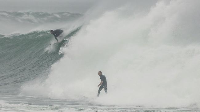
A small number of people had taken to the sea on the Gold Coast to ride the huge waves being whipped up by the cyclone.
The Premier labelled these people “idiots”, who put emergency services as risk.
“We had someone out on a jetski who had to be rescued. I would rather see that emergency services worker being able to go and knock on someone’s door and talk to them about preparation than having to get an idiot on the sea.
“I plead to the people who might think that now is a great time to go out on the surf - it’s not. It’s not just you I’m concerned for, but for the innocent person who has to go in after you.”
‘Accept responsibility’
Prime Minister Anthony Albanese remains in Canberra, where it is expected he will stay this weekend, cancelling plans to fly to Western Australia ahead of its state election on Saturday.
Mr Albanese paid credit to communities that had suffered repeated floods - such as Lismore in NSW - but said they were resilient.
“Many of these communities have suffered harsh event after harsh event after harsh event - I think particularly the people of Lismore, for example, have been knocked down,” he said.
“They get up, they get knocked down, they get up, and now (this).”
Mr Albanese also urged residents to “accept personal responsibility” and asked people to follow evacuation warnings and avoid the beach.
“Everyone has to accept personal responsibility here too. This isn’t a time for sightseeing or for seeing what it’s like to experience these conditions first-hand,” he said.
“Please stay safe, be sensible, and keep distance from these events and the impact that it’s having.
“It’s important that if the SES is advising you to evacuate, by a certain time you do so, they have knowledge, they have expertise, they have experience.
“You make their life harder, and importantly as well, it means they can be distracted from assisting others if people aren’t following the recommendations in a timely manner.”
Speaking to media on Friday, Mr Albanese said Queensland’s Chief Medical Officer had activated the Department of Health and Aged Care’s national incident centre, which would allow for nationally co-ordinated information between Commonwealth and state agencies, as well as emergency agencies.
The federal government has also approved a state NSW government request to deploy 120 ADF personnel to depart immediately for NSW.
“They’ll start work today, supporting the local SES door knocking, as well as conducting welfare checks on vulnerable members of the community,” Mr Albanese said.
Gold Coast turns grey as Alfred whips up wild conditions
Gold Coast residents have been told to stay indoors as conditions deteriorate further.
Alfred was about 140km east-northeast of the Gold Coast at 9am AEST and slowly moving towards the mainland.
Gold Coast City Council has issued warnings for everyone to stay away from the sea and waterways, as all beaches are closed.
“For safety everyone should remain indoors as conditions will be dangerous as the cyclone gets closer to land,” a City of Gold Coast spokesperson said.
“A number of trees and powerlines have fallen over the roads in heavy winds.
“We ask everyone to avoid the roads unless essential. If you must drive, take care and drive to the conditions. Remember – if it’s flooded, forget it.
Energex reports more than 20,000 customers have lost power.
Areas with the most outages are: Biggera Waters, Bilinga, Bonogin, Burleigh Heads, Coolangatta, Mudgeeraba, and Tallebudgera.
“If you see a fallen powerline, report it immediately by calling triple-0 or Energex. Do not touch a fallen powerline directly or with another object,” the council spokesperson said.
Supermarkets enter final hours of trading
Supermarkets staff will be at work until the late morning in Brisbane and the Sunshine Coast before Woolworths shuts the doors.
A Woolworths spokesperson said store hours will be updated regularly online.
“Where it remains safe and possible to do so, some of our stores in Brisbane and Sunshine Coast are open this morning to serve the community, however we expect them to close early throughout the day to ensure safe travel home for our team,” a Woolworths spokesperson said.
“While we’re working to keep as many stores open as possible, some items may be missing from the shelves as trucking services begin to be reduced ahead of the cyclone. We thank customers for their understanding as our teams do their best to support shoppers.
“As we await the landfall of Cyclone Alfred alongside these communities, our thoughts are with our team members and all those in the warning areas.
Woolworths emergency response staff are monitoring the unpredictable cyclone, and the organisation will reopen stores and restock when it is safe.
“We will take a store-by-store approach to reopening based on access to stores, team member availability and the advice of local authorities.
“Our distribution centres in the region have been receiving additional stock which will be delivered to stores once it is safe to do so and stores have reopened.”
More to come
Originally published as Tropical Cyclone Alfred to hit Moreton Island first before weakening, reaching mainland
Grim warning for flood-smashed town
Residents still recovering three years after a destructive flood are “dreading what is to come” as Cyclone Alfred barrels towards them.

‘Idiots’: Premier erupts as Aussies go nuts
Alfred is less than a day away from making landfall but many Aussies still don’t seem bothered by the looming threat.