
Ex-tropical Cyclone Tiffany moving west, severe weather warning in place
Severe weather warnings remain in place after Tiffany has officially been named an ex-tropical cyclone.
UPDATE WED 5.30PM: Ex-tropical Cyclone Tiffany has crossed the coast and is moving west towards Katherine after being downgraded.
There is still a severe weather warning in place.
The latest details reveal Tiffany is now a Tropical Low, with wind gusts of up to 95km per hour.
The weather warning in place is for “damaging wind gusts and heavy rainfall remain possible over areas close to the system as it moves further west.”
The Bureau of Metereology will not update the advice unless the system reintensifies.
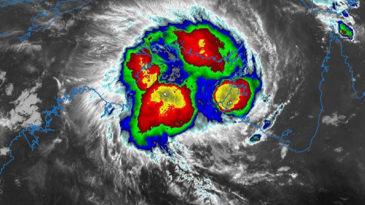
UPDATE WED 1.10pm: GROOTE Eytlandt has been spared from any major damage after Tropical Cyclone Tiffany passed through earlier today.
Tiffany is now located over land, just west of Ngukurr. It is expected to continue moving westwards during today.
Damaging wind gusts and heavy rainfall remain possible over areas close to the system as it moves further west.
BOM manager for community engagement Jude Scott said warnings for other areas of the Top End would continue to be issued.
“Tropical Cyclone Tffany crossed the coast earlier this morning as a category 1 system,” she said.
“Although the cyclone threat is easing, heavy rainfall, flooding and damaging winds remain hazards right across the Top End for the remainder of this week and into the weekend.
Ms Scott said Darwin residents had also shivered through the coldest January day on record, with the temperature almost three degrees less than the coldest day on record.
Assistant Commissioner Janelle Tonkin confirmed the system passed through the Groote region without too much of an impact.
“There are no reported injuries to any persons or any infrastructure,” she said.
They are experiencing some fairly wet and windy conditions and emergency services will continue to monitor will report as the day progresses.”
UPDATE WED 10.15am: TROPICAL Cyclone Tiffany is currently crossing the coast near Port Roper as a category 1 system.
A cyclone warning is in place for Alyangula to Port McArthur, including Numbulwar, Ngukurr and Port Roper, but not including Groote Eylandt.
The warning for Groote Eylandt has been cancelled.
At 9.30am, the BoM reported sustained winds near the centre of 75km/h with wind gusts to 100km/h.
Tropical Cyclone Tiffany is currently crossing the coast near Port Roper as a category 1 system. #CycloneTiffanyhttps://t.co/AWJKLhQwBtpic.twitter.com/aFp6Iqcq37
— Bureau of Meteorology, Northern Territory (@BOM_NT) January 12, 2022
Meanwhile, a gale wind warning has been issued for the Roper/Groote Coast, while a wind warning for Gove Peninsula Coast has been cancelled.
Tropical Cyclone Tiffany is forecast to make landfall near Port Roper around midday, then weaken to below tropical cyclone strength over the Top End later in the afternoon or evening.
Ex-Tropical Cyclone Tiffany will remain a deep tropical low as it moves across the western Top End during Thursday, near the Joseph Bonaparte Gulf, before turning to the south from Friday or Saturday.
UPDATE WED 7.30am: Tropical Cyclone Tiffany has reformed overnight and is set to cross the NT coast near Port Roper today.
The system has weakened slightly over the last few hours, and is now unlikely to reach category 2 strength before making landfall.
Meanwhile Darwin awoke to its own wild weather as a line of squalls struck the Top End capital early Wednesday morning.
However, the severe thunderstorm warning for the Darwin City and Outer Darwin area including Palmerston and Litchfield has been cancelled.
Cyclone Tiffany lies south of Groote Eylandt in the western Gulf of Carpentaria and continues to track westward. It is expected to hit the coast near Port Roper around midday Wednesday.
A category 1 landfall is now expected. Tiffany will then continue moving westwards, weakening below cyclone strength over land near the base of the Top End later today.
Bureau of Meteorology Senior Forecaster Billy Lynch said the cyclone had hit the southern part of Groote Eylandt on Wednesday morning.
“The centre of it is passing to the south of Groote Eylandt,” he told ABC Radio.
“It’s not a direct hit on Groote Eylandt, which is good news.”
Gale winds are occurring around the southern part of Groote Eylandt and beginning to affect parts of the coast. Gales with gusts to 120 km/h will extend along the coast to Port Roper and Numbulwar later this morning as the cyclone approaches and crosses the coast.

Gales may extend northward to Alyangula later today depending on the track of the system. Wind gusts up to 100 km/h may extend inland to Ngukurr late today as the cyclone moves inland before weakening.
A storm tide between Port McArthur and Alyangula, including Groote Eylandt, is expected as the cyclone centre passes Groote Eylandt and makes landfall on the mainland coast today. Tides are likely to rise significantly above the normal high tide, with damaging waves and dangerous flooding.
Heavy rain is expected across parts of the Arnhem and Carpentaria districts and is expected to cause flooding of low lying areas and river rises. Heavy rain is also likely to extend westwards into the Daly district on Thursday.
Mr Lynch said Cyclone Tiffany was about three hours ahead of schedule from what had been forecast on Tuesday.
“It just ran out of time. It probably got a bit too close the coast too, so it has weakened and hasn’t developed quite as quickly as we were anticipating either,” he said.

“We’re (now) really just focusing on that part of the coastline around the southwest Gulf of Carpentaria … Port McArthur, Numbulwar, Groote Eylandt and Ngukurr probably being the main communities that need to keep listening to the latest advice and take shelter as conditions deteriorate today.”
A warning was cancelled for Cape Shield to Alyangula, Port McArthur to the NT/Queensland border, and inland areas including Bulman. .
The cyclone is forecast to weaken later Wednesday afternoon or evening over land, with the low continuing to track across the base of the Top End.
“The focus will definitely shift towards the amount of rainfall that it can produce,” Mr Lynch said.
Emergency Services advised residents who are not able to safely shelter at home to take their emergency kits with them to the shelters and put into place arrangements for care of any pets.
Public shelters are located at:
Angurugu School Trade Training Centre – OPEN
Umbakumba School Trade Training Centre – OPEN
Milyakburra Cyclone Shelter – OPEN
Numbulwar School – OPEN
EARLIER: NUMEROUS Covid positive cases on Groote Eylandt have adequate shelter to isolate as Cyclone Tiffany was due to strike the area with fierce winds and significant rainfalls from Tuesday night, NT Police say.
At the Nightcliff Police Station on Tuesday, Acting Superintendent Bradley Fox said affected communities along the east coast of the Territory — from Nhulunbuy to the Queensland border — were well prepared for the approaching cyclone.
Additional staff have also been deployed at several locations, including Numbulwar, with the cyclone expected to revert back to a category two on Wednesday after crossing Cape York Peninsula.
However, he said “several” people infected with Covid on Groote Eylandt were able to isolate without impacting others and were in “appropriate locations”.
“They are isolating as per the pandemic plans,” Acting Superintendent Fox said.
“We have sufficient shelters in place to accommodate, to address the needs of the whole community.”
He also said there were no plans to evacuate anybody from weather-affected areas.
“We are sufficiently staffed to address the needs of the communities who are affected,” he said.
“The sense on the ground (is Groote Eylandt residents) are well motivated to listen to the local authorities.
“They’ve been through this before, many, many times before, and there is no negativity whatsoever, we’ve not had any adverse feedback.”
He said Covid had not impacted any emergency services response to the cyclone.
NT Health was not able to report the number of Covid-infected people on Groote Eylandt before deadline.
EARLIER: CYCLONE Tiffany is set to make an impact bringing heavy rains and winds with it sparking concerns of a floods across the Top End particularly in Katherine.
Katherine is no stranger to extreme flooding with perhaps the worst in recent memory coming in 1998 with only rooftops peeking over the top of the floodwaters.
In 2006 things were wet once again as a result of Cyclone Monica.
And while it is hoped this oncoming storm won’t leave the same result the Katherine River as well as the Daly and Roper Rivers have been added to the Flood Watch.

Daily rainfall totals of 50-150mm with isolated falls of 150-300mm are possible across the Carpentaria Coastal Rivers on Wednesday and Thursday.
BOM senior meteorologist Billy Lynch said while there were concerns of floods in the region they couldn’t yet predict what it would mean for the region.
“There are concerns that could be floods in the Katherine River region and as a result it has been added to Flood Watch,” Mr Lynch said.
“We’re not making predictions yet on how much rainfall we will get or where it will be heaviest but there is the potential for some heavy rainfall over the Roper, Daly and Katherine River regions.
“People should stay up to date with information and emergency service advice and once the weather deteriorates make sure they and their families are safe. Stay out of the weather and be sensible.”
“Over the past 5-10 years when you look at weather related fatalities it is usually flood related with people crossing rivers or flooded passes. Flooding is a life or death situation.”
Catchments currently on Flood Watch include Lower Daly River, Daly River above Douglas River, Katherine River, Walker River, Groote Eylandt, Waterhouse River, Roper River and Towns River.
EARLIER: RESIDENTS on Groote Eylandt have been told they do not need to evacuate as fears Cyclone Tiffany could progress to a category three weather event fade.
Bureau of Meteorology NT senior officer Jude Scott said the fast-moving Tiffany was expected to “re-intensify to cyclone strength” today as it passed over the Gulf of Carpentaria and headed towards the Territory’s east coast, approaching category two tomorrow.
However, she said Groote Eylandt residents could expect “damaging to destructive” wind gusts from Tuesday night of up to 165km/hr and sustained winds of up to 120km/hr.
The Territory’s east coast could also expect “significant rainfall totals” for the rest of the week.
“The first impacts will be felt on Groote Eylandt overnight,” Ms Scott said.
“All community are encouraged to be prepared for damaging to destructive winds … in the coming days.
“The system is moving quite quickly … at this stage we don’t think it’s going to spend enough time over water to intensity to (category) three strength.
“We’re urging all communities to be ready for some really heavy rainfall, damaging to destructive wind gusts, and that’s going to kick in from tonight on Groote Eylandt.”

She said residents on the coast could still expect daily rainfall of up to 300mm in some areas and there were also flood watches in place for Carpentaria coastal rivers.
She expected the cyclone to continue to track west “across the base of the Top End”.
Meanwhile, NT Police Acting Superintendent Bradley Fox said affected communities were well prepared while additional staff have been deployed at several locations, including Numbulwar.
“At this stage there are no plans to evacuate any person in the weather-affected areas,” Act Supt Fox said.
“We are sufficiently staffed to address the needs of the communities who are affected.
“The sense on the ground (is Groote Eylandt residents) are well motivated to listen to the local authorities.
“They’ve been through this before, many, many times before, and there is no negativity whatsoever, we’ve not had any adverse feedback.”
However, he said there were “several” Covid positive cases sheltering on Groote Eylandt but they were in “appropriate locations” and not isolating with non-infected people.
“They are isolating as per the pandemic plans,” he said.
“We have sufficient shelters in place to accommodate, to address the needs of the whole community.”
He also said Covid had not impacted any emergency services response to the cyclone.
However, NT Emergency Service spokeswoman Gemma Bellenger said “the time to act is now” for affected communities.
“By planning ahead it will reduce injury and damage to the property,” Ms Bellenger said.
“Think about your pets and think what about what special need items that you will need to include in your kit.”
EARLIER: THE Bureau of Meteorology NT has issued a severe thunderstorm warning for Groote Eylandt and parts of Arnhem District ahead of a cyclone forecast to hit tomorrow.
The warning is for damaging winds and heavy rainfall that could lead to flash flooding in the area over the next several hours.
“A band of severe thunderstorms on the western periphery of Ex-Tropical Cyclone Tiffany are moving from south to north across the western Gulf of Carpentaria,” the statement reads.
According to BOM a 100km/h wind gust was recorded at Centre Island at 7.31am this morning.
The Northern Territory Emergency Service has provided the following advice:
* slow down and turn your headlights on
* create your own sandbags if there is flooding, by using pillow cases or shopping bags filled with sand and place them around doorways to protect your home
* secure loose outside objects
* ensure pets and animals are safe
* avoid remaining in the open when storms threaten
* pull over if it is raining heavily and you cannot see, park with your hazard lights on until the rain clears
* avoid driving into water of unknown depth and current
If you’re in need of emergency help contact NTES on 132 500 and stay across warnings and safety tips at www.secure.nt.gov.au
âš ï¸ Severe #thunderstorm warning for Groote Eylandt and parts of Arnhem District. Damaging #wind & #HeavyRainfall as severe thunderstorms approach Groote Eylandt. Stay up to date with warnings https://t.co/kwhQp1Q1pl
— Bureau of Meteorology, Northern Territory (@BOM_NT) January 11, 2022
MONDAY 8AM: EX-TROPICAL Cyclone Tiffany, which weakened overnight, has moved over North Queensland and into the Gulf of Carpentaria. It is expected to reform on Tuesday.
The cyclone remains forecast to move near Groote Eylandt early Wednesday morning, however the forecast impact has been downgraded from a category 3 to a category 2 impact.
A tropical cyclone warning is now in place for the region.
Gales are expected to brings winds up to 140km/h on Wednesday.
“People on Groote Eylandt should be aware that from early (Wednesday) morning – sometime between midnight and sunrise – the gale force winds are expected to develop and then during the day between Nhulunbuy and the Queensland border, could experience the gale force winds associated with the tropical cyclone,” Senior forecaster Billy Lynch told ABC Radio on Tuesday morning.

People in Nhulunbuy to Queensland border, including Numbalwar, Port Roper, and Borroloola, remain part of the watch zone.
Emergency Services advised people in the affected areas are advised to finalise their emergency kits, tidy their yards of loose objects and know where they will take shelter.
EARLIER: UP TO 4000 people in Gulf of Carpentaria communities could be impacted by Tropical Cyclone Tiffany in coming days as it moves west towards the Northern Territory.
At the Nightcliff Police Station on Monday, Bureau of Meteorology NT manager Shenagh Gamble said the category two system, which is currently crossing Cape York Peninsula, had already impacted people in far north Queensland.
She said the cyclone was expected to intensify as it moved west and hit the Gulf of Carpentaria on Tuesday morning, before possibly impacting communities on Groote Eylandt and Numbulwar by Wednesday morning as a “possible category three” system.
She said residents on Groote Eylandt and Numbulwar could expect wind gusts up to 200km/hr, and sustained winds of over 120km/hr, if it progressed to a category three weather event.
A category two cyclone would see sustained winds of over 100km/hr and gusts of around 120km/hr.
She said the east coast of NT could also see daily rainfall of up to 300mm in some areas.

“Tropical cyclones in the Gulf of Carpentaria are notoriously erratic,” Ms Gamble said.
“The exact path of the system and the duration of the event will be clarified as we know more.
“We are issuing tropical cyclone watch for the communities from Nhulunbuy to the Queensland border.
“The exact path and strength of this cyclone may change in the coming days.
“It is going to bring in monsoonal conditions … wet and windy conditions.”
Ms Gamble said the last tropical cyclone which made a “territory coastal crossing” was Cyclone Esther in 2020, which also travelled through the Gulf of Carpentaria, and the last severe tropical cyclone – exceeding category three level – was Cyclone Trevor in March, 2019.

NT Police Acting Assistant Commissioner Janelle Tonkin said “lots of preparation was underway” despite the “uncertainty” of the approaching cyclone.
She said residents in “likely” impacted communities had to ensure cyclone kits were ready and “that your planning and preparation is complete”.
“If your plan is to evacuate, now is the time to start making those preparations,” assistant commissioner Tonkin said.
“We’re probably looking around the 3000 to 4000 mark (of people impacted).
“Groote Eylandt has shelter, capacity for (category) three, but the advice will be at this point to shelter and stay in location.”
She said NT emergency services were not planning for the evacuation of residents yet.
“We’re keeping an open mind. Cyclones can be notoriously unpredictable,” she said.
“It’s too early to speculate. We’re not at that point.”
NT Emergency Service spokeswoman Gemma Bellenger encouraged residents in affected areas to store food and water for up to three days and to have an emergency plan prepared.
She also encouraged residents to get their backyards “cyclone ready” and stow away anything that could be picked up by strong winds.

Join the conversation

‘Unitedness’: Inside Darwin’s Festival of Us line-up
Read more

Murder charge five years after NT nurse found dead in backyard
Read more