
Storms dump 60mm of rain in an hour as massive rainband crosses southeast
Southeast Queensland is experiencing its coldest day of the year so far, with the Bureau of Meteorology saying there’s a chance of more storms in some parts.

QLD News
Don't miss out on the headlines from QLD News. Followed categories will be added to My News.
Southeast Queensland is experiencing its coldest day of the year so far, with the Bureau of Meteorology saying there’s a chance of more storms in some parts.
The cold front sweeping through the state’s south will keep conditions cloudy and cool, with Bureau Meteorologist James Thompson saying daytime temperatures will be below average over throughout the week.
“We are seeing a small chance of a couple of severe thunderstorms today across the Wide Bay and Burnett district and into the central west as well,” Mr Thompson said.
“Significant rain may be on its way for parts of central and southern inland Queensland from Tuesday to Thursday with widespread moderate rainfall totals expected.
“Daytime temperatures are to remain significantly below average for the first half of this week over the south of Queensland.”
EARLIER: Snap cold front after storms dump 80mm overnight
A cold front will sweep into southeast Queensland today sending temperatures plummeting after fast-moving storms dumped over 80mm of rain overnight.
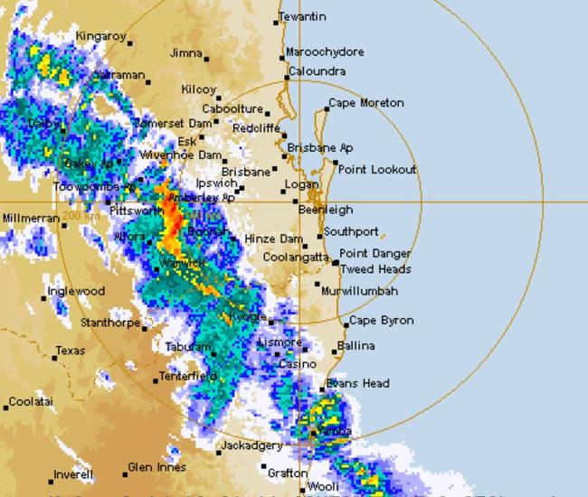
The Bureau of Meteorology issued a severe storm warning just before 8.50pm on Sunday for heavy rainfall across the Wide Bay and Burnett and Darling Downs and Granite Belt regions.
Heaviest hit was Condamine with 65mm, Jandowae with 59mm and Condamine with 80mm.
Today, temperatures are forecast to plunge by as much as 11C with widespread rain and potential storms across southern Queensland.
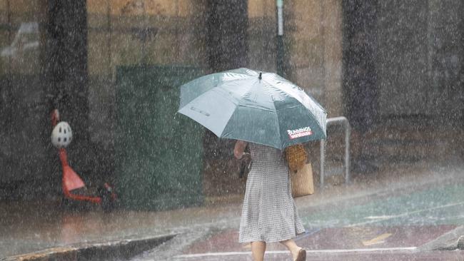
It will only get to 23C in Brisbane with the potential of 20mm of rain. The Sunshine Coast could get up to 25mm while 60mm may fall on the southern Darling Downs.
Bureau of Meteorology meteorologist James Thompson said temperatures were forecast to drop well below the March average and widespread rain would move across much of the southeast.
He said Monday’s weather would be “quite a dramatic change” from Sunday, with a high chance of some showers and light rain.
“When that trough moves through (Monday) morning, we’ll see southerly winds which will be bringing that really cool air into southeast Queensland and cloudy conditions as well
“Temperatures are not going to rise too much from what it is in the morning, so sort of the low to mid 20s expected through tomorrow for the maximum temperatures.”
Stanthorpe will likely be the coldest place in the state on Monday with a forecast maximum of 18C, down from 28C today.
Brisbane is set to hit a top of 22C, Warwick will reach 20C and Toowoomba is forecast for a maximum temperature of 19C – down from 30C today.
Mr Thompson said “widespread light rain” will impact most of the southeast tomorrow.
“Generally under the cloud band tomorrow where we see that light rain, probably more like 10mm or so,” he said.
A spectacular cloud line has rolled into #Qld, ahead of the cold change & rainfall expected later today. Max temps in the far SW will drop >15C between today & tomorrow. â„ï¸ The cold air will get to #SEQ early next week, bringing a gradual 4-6C drop. https://t.co/2kZj6WSBHVpic.twitter.com/rFSGRFd7eJ
— Bureau of Meteorology, Queensland (@BOM_Qld) March 13, 2021
There is also the chance of storms tomorrow about the southeast, with possible severe storms in the Wide Bay and Darling Downs regions.
Temperatures are forecast to begin to rise from Tuesday and return to March averages by the end of the week.
Originally published as Storms dump 60mm of rain in an hour as massive rainband crosses southeast
‘I have no girls left’: Next chapter revealed for Hannah Clarke’s shattered parents
Five years after the tragedy that horrified the nation and crushed a close-knit Queensland family, Lloyd and Sue Clarke are ready to begin their next chapter. But it’s a move that’s not without deep sadness.
Shock moment TV host, Origin star’s Qld property broken into
A Queensland TV news reporter has shared the “confronting” experience she had when she woke to find intruders armed with a tomahawk and a baseball bat on the property she shares with her State of Origin star husband.