Bushfire advice issued for three blazes near Stuart Hwy
Bushfires NT has issued a warning for motorists and residents as three bushfires burn uncontained along the Stuart Hwy.

Northern Territory
Don't miss out on the headlines from Northern Territory. Followed categories will be added to My News.
THREE separate bushfires were burning between Three Ways and Larrimah along the Stuart Hwy on Wednesday afternoon.
Bushfires NT said the blazes were burning on at least one front and containment strategies were not yet in place.
Motorists were being urged to monitor the situation, with smoke and fires potentially posing a hazard along the Stuart Hwy. Fire crews were also potentially working close to the road.
Bushfires NT warned the situation could continue until 8am Thursday.
‘Hot and sticky’ this week as heatwave set to develop over parts of Top End: BoM
RESIDENTS of parts of the Top End are in for a hot and sticky time this week with a heatwave developing, Bureau of Meteorology forecaster Angeline Prasad says.
“We’ve got a low to severe density heatwave developing over much of the inland parts of the Top End, the focus will be mostly over Arnhem and around the Katherine area,” Ms Prasad said.
“We have got a heatwave that’s building near the base of the Top End, across the Arnhem and much of the inland parts.

Katherine is in for an absolute stinker of a day with a top temperature of 40 degrees. It will be partly cloudy with light winds throughout the day.
Alice Spring is forecast to experience a maximum temperature of 30 degrees and Darwin a top temperature of 33 degrees, with light winds throughout the day.
“We will see a shower, maybe a thunderstorm but that is more likely in the second half of the week,” she said.
“The next couple of days is going to be quite uncomfortable, it will pretty much be a continuation of what happened (Sunday).
“It is going to be quite hot.”
Up to 34mm falls in Top End in beginning to Wet
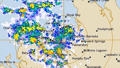
DARWIN has been drenched with over 20mm of rain in the 24 hours to Saturday morning, as Top End residents waking up to an early thunderstorm.
The Bureau of Meteorology has recorded 20mm having fallen in the Territory capital in the 24 hours to 9am Saturday.
Noonamah recorded 34.6mm and Charles Point 23.8mm over the same time frame.
Friday marked the first official day of the wet season.
Darwin is forecast to hit a top of 32C on Saturday, with conditions easing through the day.
There will remain the chance of a thunderstorm through the afternoon and evening.

The Bureau predicts a top of 33C on Sunday and 34C on Monday with mostly sunny conditions and a less than 10 per cent chance of rain.
In Alice Springs, a cool chance is forecast to come through on Wednesday next week, with a 40 per cent chance of rain.
Thursday is forecast to hit a top of 24C.


