
BOM issues severe weather warning as monsoon trough dumps rain on Top End
The Bureau of Meteorology says Territorians should be on alert for flash flooding as a monsoon trough continues to dump heavy rain and squalls over much of the Top End.
Northern Territory
Don't miss out on the headlines from Northern Territory. Followed categories will be added to My News.
UPDATE DEC 27: THE Bureau of Meteorology says Territorians should be on alert for flash flooding as a monsoon trough continues to dump heavy rain and squalls over much of the Top End.
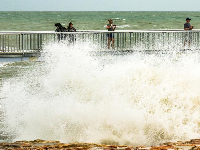
A severe weather warning for damaging winds and heavy rainfall was issued early Monday morning for people in Daly, Tiwi, Arnhem and parts of Carpentaria and Gregory districts.
Monsoon rain and squalls are forecast to continue across the Top End in the coming days.
A tropical low is located over land near Nauiyu and is moving slowly eastwards across the Daly District, while the monsoon trough extends eastwards across the northern Top End.
Heavy rainfall which may lead to flash flooding is expected to continue across the Arnhem, Daly, Tiwi and northwest Carpentaria and northeast Gregory districts.
Damaging winds with gusts of up to 100 km/h with monsoonal squalls may develop mainly about the west and north coast, extending further east and south across the Carpentaria and Arnhem District during Monday as the tropical low moves east.
UPDATE SUNDAY AFTERNOON: A BOXING day bonus for Territorians – with a potential cyclone running out of puff and the associated weather delivering Darwin its coldest Christmas Day since records began in 1941.
It got to a cool 27.3C on Saturday.
Bureau of Meteorology senior officer Jude Scott said the tropical low west of Darwin moved on Saturday night over coastline south of Dundee Beach but did not settle over water long enough to intensify into a cyclone.
However, Ms Scott predicted the monsoon would continue to strengthen as the tropical low tracked east towards the Gulf of Carpentaria, and coastal Top End communities would be affected.
“Heavy rainfall and damaging winds will continue to impact the Top End during the next two days as the tropical low tracks east towards the Gulf of Carpentaria and the monsoon continues to strengthen.
“The Bureau will continue to issue severe weather warnings for heavy rainfall, flash flooding and damaging winds, with conditions starting to ease across the Top End from Tuesday.” Strong wind warnings are current for much of the northern coastline and regular downpours of between 50 and 100 millimetres will continue to be recorded over the next two days.
Maningrida and Milingimbi each recorded rainfall in excess of 200mm over the Christmas period.
Mark Cunnington, regional manager with NT Emergency Service, warned Territorians not to be complacent despite the reduced risk of a cyclone. “Severe weather is expected to continue across the next couple of days so despite the fact the cyclone threat is diminished, we still have issues potentially with floods and strong winds,” Mr Cunnington said.
“We’d like to see people stay away from floodwaters. Don’t drive into flooded crossings – turn around and don’t drown. “Be mindful of conditions on the road and drive to safe conditions and if you’re looking at going boating in the next couple of days then be safe on the water.
“Make sure you take emergency supplies and make sure people know where you’re going.” Emergency Service responded to four call-outs around Palmerston in response to trees falling on homes, minor flooding and a roof leak, but there were no evacuations. “As we progress through the week the ground has become soaked, trees have a tendency to blow over as the wind direction changes as the tropical low moves.
“Communities should be checking their particular flood issues. There will be a number of areas getting quite wet so through the Daly, Katherine all the way out to Borroloola in the east.
“Just be mindful there’s a lot of water coming. Rivers will rise and we may see localised flooding in some of those areas.” At this stage though Emergency Service are not anticipating a significant flooding event such as one that hit Katherine in 2009.
“Our advice is we’re not expecting the intense rainfall required to achieve that level of concern, however it will all depend on what the system does. This system is expected after tomorrow to make a fairly quick move across the Top End and not spend a lot of time over any of the catchments.”
For 12-year-old Clem Heaslip, the cool Christmas didn’t interfere with her holiday fun other than the unusual battle to stay warm in the Northern Territory.
UPDATE DEC 26: THE tropical cyclone warning for the northwest Top End has been cancelled, with the low pressure system moving across Darwin’s coast not expected to develop further in the short term.
However, a severe weather warning was issued late Saturday night for much of the Top End, with damaging winds and heavy rainfall forecast for people in Daly, Tiwi, Arnhem and parts of Carpentaria districts.
A Flood Watch warning is also current for parts of the Top End.
The monsoon is strengthening across the Top End as a tropical low crossed western Top End coast, southwest of Darwin. The monsoon trough is expected to move further inland from the north coast on Sunday.
A tropical low is located southeast of Dundee Beach and is moving slowly in a southeast direction across the Daly district, bringing heavy rain and squalls over large parts of the Top End.
Heavy rainfall which may lead to flash flooding is expected to continue today across the Arnhem, Daly, Tiwi and northwest Carpentaria districts.
Rainfall totals over the 24-hour period of 150-250mm and isolated falls to 300mm are possible.
Damaging winds with gusts of up to 100 km/h with monsoonal squalls may develop mainly around the west and north coast on Sunday.
These conditions may extend further east and south across the Carpentaria and Arnhem District later on Sunday.
EARLIER: PARTS of the Territory could take a battering from a cyclone expected to cross the coast on Boxing Day.
Bureau of Meteorology NT manager Shenagh Gamble said a tropical low handing off the Tiwi Islands was expected to develop into a category one system on Sunday December 26.
Ms Gamble said the weather system was in “favourable conditions” to develop by 3pm on Sunday December 26, and make landfall at Dundee Beach, 105 km west of Darwin and 100 km southwest of Milikapiti.
She said whether the system reached cyclone strength depended on how long it spent over water.
The BOM warned the tropical low was slowly developing to the north northwest of Darwin and was expected to strengthen and continue moving south.
On Saturday afternoon the BOM increased its caution from cyclone watch to cyclone warning for all areas between the Western Australian border to Point Stuart, including Darwin and the Tiwi Islands.
The metrologist said a severe weather warning applied to most of the Territory coast, with heavy rainfall and strong winds expected for the northern Arnhem district.
Gales with gusts to 100 km/h may develop between Point Stuart and Wadeye, including Darwin, during Sunday depending on the track of the system.
“Driving around the Top End will be dangerous due to flash flooding and reduced visibility,” Ms Gamble said.
Tidal warnings have also been issued between Point Stuart and Wadeye.
The meteorologist said the heavy rainfall had already reached the NT, with some areas like Gunn Point and Point Stuart hit with over 150mm overnight.
“It will be more of the same over the next few days,” she said.
Police assistant commissioner Martin Dole advised everyone to pay attention to emergency updates throughout the weekend and avoid unnecessary trips.
“If you do not need to travel, please avoid using the roads until the wet weather has passed and it’s safe to do so,” Mr Dole said.
“This includes boat-goers, who should keep off the water until it’s safe.”
Northern Territory Police, Fire and Emergency Services have stood up an Emergency Operations Centre to co-ordinate the preparation for and response to this event.
Mr Dole said shelter areas were being assessed at Dundee Beach, as emergency services prepare for the system to make landfall.
Mr Dole said anyone in Dundee Beach who was not cyclone ready should leave now.
NT Emergency Services northern region manager Mark Cunningham implored people to be sensible in the rains.
“Stay away from flood waters, they kill,” Mr Cunningham said.
“Turn around and don’t drown.”
He said anyone planning on going out on the boat or fishing should reconsider.
The NTES has recommended all Territorians finalise their cyclone preparations, including having an emergency kit ready, shelter indoors as conditions deteriorate and reconsider any need to travel or drive.
EARLIER: Territorians are being urged to reconsider any travel to Channel Point, Dundee Beach and Bynoe Harbour following the announcement of a tropical cyclone watch.
Territorians are also discouraged not to move around the Tiwi Islands.
A statement from NT Police, Fire and Emergency Services said north western coastal communities could be affected by strong winds from tomorrow.
“If you do not need to travel, please avoid using the roads until the wet weather has passed and it’s safe to do so,” the statement said.
“This also includes boat-goers, please keep off the water until it’s safe.”
EARLIER: THE risk of a Tropical Cyclone striking over the Christmas weekend has increased as the Top End has been put on Cyclone Watch.
The developing tropical low sitting north of the Tiwi Islands is heading south towards the NT and the Bureau of Meteorology expect it to intensify over the weekend.
The system has been upgraded to a moderate chance (20-50 per cent) of becoming a cyclone on Saturday but is a high risk (over 50 per cent) on Boxing Day Sunday and Monday.
Cyclone advice is currently in place for this system with it being advised for people to have a plan in place ahead of the storm and avoid floodwaters as much as possible.
Refer to www.bom.gov.au/cyclone for further information.
EARLIER: THE Bureau of Meteorology has issued a tropical cyclone watch for the Top End following the intensifying of a developing tropical low overnight.
A tropical low which has been developing over the past week currently sits north of the Tiwi Islands and looks set to impact the NT over the weekend.
Territorians can expect strong winds with chances of a category one storm potentially crossing the coast near but not directly over Darwin on Monday.
Shenagh Gamble of BOM said that a tropical watch would be declared on Christmas Eve with communities from Point Stuart to Kalumburu in Western Australia as well as Darwin to be effected.
“Communities along the coast may be affected by damaging winds of up to 100km/h from as early as tomorrow evening,” Ms Gamble said.
“The cyclone watch will be updated every six hours as the tropical low may intensify to a tropical cyclone strength offshore on Boxing Day.”
Senior Meteorologist Billy Lynch said that the system is being closely monitored by the Bureau and communities in the Top End should expect lots of wet weather and strong winds.
“We are expecting heavy rainfall of around 200mm over the next four days, which also increases the risk of flooding in the region.
“Tropical systems can intensify quickly, and shift direction, so it’s a good time to remind Northern Territorians to check their emergency plan and cyclone kits before they go on their Christmas holiday break and to take extra care on the roads.”
A Darwin International Airport spokeswoman said there was no impact to flights yet, but airport had moved to Stage 1 of its Cyclone Plan in reaction to the developing weather conditions.
“If it a Cyclone Warning is declared a Cyclone Committee meeting will be convened, which includes airlines and other key stakeholders,” she said.
She said the safety of passengers, flight crew and staff was the top priority, so if the cyclone situation escalated the airport may be forced to close or divert flights.
“The airport would not be closed to civil operations until Stage 4, however airlines would most likely cease operations prior to then,” she said.
“As for timing these things can be a bit tricky to say.
“We won’t be doing it with just 10 minutes to spare, that would be ridiculous.
“There will be enough time to ensure the safety of all people impacted.”
EARLIER: TOP Enders should brace themselves for torrential rains over the Christmas weekend as the risk of a potential cyclone forming on Sunday has been increased to moderate.
A very weak circulation currently lies in the northern Arafura Sea which could develop into a tropical low on Friday leading into Christmas.
The Bureau of Meteorology currently estimates a low (5-20 per cent) chance of a cyclone forming on Christmas Day but chances go up another level on Sunday to a moderate risk (20-50 per cent).
The systems development into a cyclone depends on the direction it tracks as it moves south towards the Top End.
If the system tracks south its development will be inhibited by land however it moves southwest then it will likely intensify over the Timor Sea.
EARLIER: WET weather is tipped to be the flavour of the day come Christmas and what’s more is that a tropical cyclone also looks set to form just in time for the holiday.
A monsoonal trough forming in the northern seas has a chance of developing into a cyclone which could come to town for Christmas.
However, Christmas would be the earliest eventuality if a cyclone were to form.
The Christmas Day outlook sees a low (5%-20%) chance of a cyclone forming, although this could increase closer to the date.
Should this be the next cyclone to form in Australia it will be known as Seth however it forming relies on a number of contingencies including which direction the weather system tracks.
Bureau of Meteorology meteorologist Moses Raico said that there were a very high chance of storms in the Darwin region on Christmas Day with showers across the NT.
“There is a very high chance of showers and thunderstorms with cooler and cloudier conditions across the Top End on Christmas Day,” Mr Raico said.
“With the monsoon approaching us we could see potentially see 20-50mm of rain a day from Friday, it could though be significantly higher along the coast.
“We are seeing an increasing chance of a tropical cyclone developing from the weekend with a monsoonal flow starting to develop across parts of Indonesia.
“With any low that develops at this time of year it does increase the risk of a tropical cyclone, it all depends on the amount of time the low stays over water and what track it takes.
“There is a low chance from Saturday to our north but there is a lot of uncertainty as to the exact track which would decide if it forms into a cyclone or not.
“We’re confident that the monsoon trough will develop, we’re confident it will drift south to the Top End and we’re confident a low will develop there just not what track it will take.”

Gus Fitzgerald is a massive rain lover and is looking forward to more in the lead up to Christmas after a wet season that has so far been full of hot weather.
“We’ve had some good recent rains and that’s something I want more of instead of this hot weather,” Mr Fitzgerald said.
“It’s always good when it rains over Christmas, its lovely when that happens, and it would be great if it rains on Christmas Day.”
Currently the Bureau of Meteorology is forecasting a maximum temperature of 31 degrees in Darwin on Christmas Day, with a predicted 95 per cent chance of rain and a chance of a thunderstorm.
The community is reminded to stay on top of warnings and ensure plans and emergency kits are ready.
EARLIER: End communities should be prepared for the potential of tropical cyclones in coming weeks, with the Christmas Day outlook at a 5 to 20 per cent chance of one forming.
The Bureau of Meteorology said the likelihood could increase during the rest of the Christmas weekend.
A high chance of a wet and windy Christmas weekend for the Top End is forecast, with rainfall totals of 50 to 100mm across four days expected.
Higher totals are anticipated in coastal areas.
There is also a medium chance of storms in Katherine at the weekend and south of Tennant Creek.
EARLIER: WET weather is tipped to be the flavour of the day come Christmas and what’s more is that a tropical cyclone also looks set to form just in time for the holiday.
A monsoonal trough forming in the northern seas has a chance of developing into a cyclone which could come to town for Christmas.
Should this be the next cyclone to form in Australia it will be known as Seth however it forming relies on a number of contingencies including which direction the weather system tracks.
Currently the Bureau of Meteorology is forecasting a maximum temperature of 31 degrees in Darwin on Christmas Day, with a predicted 95 per cent chance of rain and a chance of a thunderstorm.


Join the conversation

Girl dies after being struck by falling tree in Darwin yard
A falling palm tree has claimed the life of a young girl in a Darwin suburb.
Read more

Red Centre rockers return: New single, tour announced
A group of Red Centre rockers have returned with a brand new single hot off the back of headlining shows down south – but it’s not the only big news they have.
Read more