Cyclone Trevor slammed into NT mainland as a severe Category 4 system
CYCLONE Trevor slammed into the NT mainland about 11am Saturday as a severe Category 4 system with ‘wild’ winds of up to 250km/h. The system is continuing to wreak havoc on the NT as a tropical low
Northern Territory
Don't miss out on the headlines from Northern Territory. Followed categories will be added to My News.
UPDATED: Destructive Tropical Cyclone Trevor has weakened to a tropical low west of Brunette Downs.station after making landfall on the Northern Territory coast on Saturday as a severe Category 4 system.
Readings reveal that, at its peak, Severe Tropical Cyclone Trevor’s wind gusts were similar to wind speeds from the Territory’s most infamous storm, Cyclone Tracy, before Trevor was downgraded to a tropical low.
The Bureau of Meteorology has advised that the low is still packing sustained winds of 55km/h near the centre of the system with wind gusts of up to 85km/h.
The system is moving southwest at 22km/h.
Tropical cyclone Trevor has weakened into a tropical low, but severe weather is still expected. Refer to Severe Weather Warnings: https://t.co/nh45mQbCdm #CycloneTrevor pic.twitter.com/noorL28tUo
— Bureau of Meteorology, Northern Territory (@BOM_NT) March 23, 2019
Severe Tropical Cyclone Trevor packed wind gusts of up to 250km/h at its peak, on a par with those recorded during 1974’s devastating Cyclone Tracy.
Measuring equipment at Darwin Airport recorded a wind gust of 217km/h during Cyclone Tracy before the equipment was obliterated in the storm.
But sustained gales are no longer expected near the centre of ex-tropical cyclone Trevor, however damaging and locally destructive wind gusts are still possible, along with thunderstorms.
Heavy rainfall is likely to cause significant river rises and localised flooding in the southern Carpentaria and eastern Barkly districts, extending into the northern Simpson district on Monday.
Tides between Port McArthur and the NT/Qld Border will remain significantly above the normal high tide on Sunday morning, with large waves on the shoreline.
A severe weather warning is current for these conditions;
Residents in the severe weather warning area should prepare for severe weather — an increase in damaging winds and rain — and should take shelter as conditions deteriorate.
EARLIER: Tropical Cyclone Trevor has weakened to a Category 1 system after making landfall on the Northern Territory coast on Saturday as a severe Category 4.
The cyclone weakened over land near Creswell Downs.
Flooding and damaging winds still a major risk.
Tropical Cyclone Trevor, Category 1, weakening over land near Creswell Downs. Flooding and damaging winds still a major risk. #CycloneTrevor https://t.co/AWJKLhynnl pic.twitter.com/puMKdipD5q
— Bureau of Meteorology, Northern Territory (@BOM_NT) March 23, 2019
The still dangerous storm system has sustained winds near its centre of 75km/h with wind gusts to 100km/h.
Tropical Cyclone Trevor is expected to weaken below cyclone strength during Sunday morning west of Brunette Downs.
EARLIER: Destructive Tropical Cyclone Trevor has been downgraded to a Category 2 system after making landfall on the Northern Territory coast on Saturday morning as a severe Category 4.
The still dangeroustropical cyclone is now located over land between Cape Crawford and the NT/Qld border.
Dangerous conditions will extend further inland during the night.
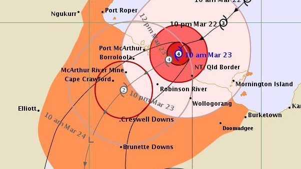
Trevor is currently estimated to be 90km south of Borroloola and 65km west of Robinson River.
Tropical Cyclone Trevor located over land between Cape Crawford and the NT/Qld border has been downgraded to Category 2. Dangerous conditions will extend further inland during tonight. #CycloneTrevor https://t.co/AWJKLhynnl pic.twitter.com/OOofBFBlxs
— Bureau of Meteorology, Northern Territory (@BOM_NT) March 23, 2019
The cyclone is still packing sustained winds near its centre of 110km/h with wind gusts to 155km/h.
Affected areas still in the Warning Zone include from Bing Bong to the NT/Qld Border, inland parts of the Carpentaria District and Barkly District, including Borroloola, Robinson River, Wollogorang, McArthur River, Cape Crawford, Creswell Downs and Brunette Downs.
The destructive core of Tropical Cyclone Trevor is expected to weaken further as it moves into the Barkly District overnight.
The system is expected to weaken below cyclone strength during Sunday morning west of Brunette Downs.
EARLIER: Severe Tropical Cyclone Trevor started to cross the NT coast below Port McArthur about 11am Saturday morning at a destructive Category 4 strength, according to the Bureau of Meteorology.
Cyclone Trevor slammed into the NT mainland with sustained winds near the centre of 165km/h and “wild” wind gusts of up to 250km/h.
The centre of Severe Tropical Cyclone Trevor is located over land between Borroloola and the NT/Qld border. Dangerous conditions will extend further inland during tonight. #CycloneTrevor https://t.co/AWJKLhynnl pic.twitter.com/CIJlDX28DC
— Bureau of Meteorology, Northern Territory (@BOM_NT) March 23, 2019
The BoM said the weather at Borroloola had become severe Saturday afternoon as Trevor moved inland, with destructive sustained wind speeds around 110km/h and gusts at about 140km/h.
Very dangerous storm tides, with damaging waves were expected to continue throughout Saturday and Sunday.
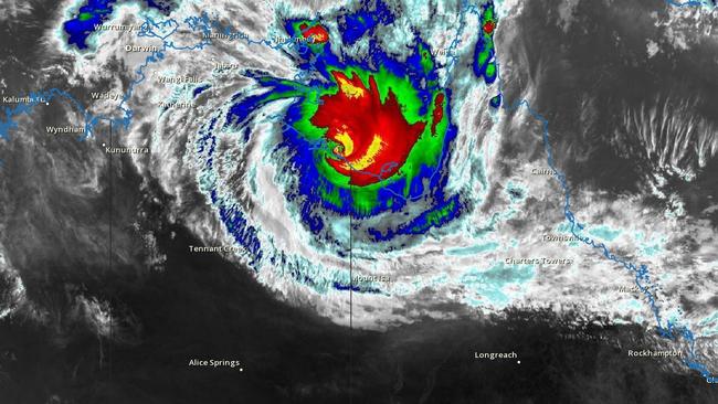
5:30pm NZDT / 2pm ACST - #CycloneTrevor as seen via Himawari satellite: pic.twitter.com/UQr3ADAv21
— WeatherWatch.co.nz (@WeatherWatchNZ) March 23, 2019
The whole of the Gulf of Carpentaria will remain very dangerous, with a hurricane force wind warning for the Roper Groote Coast Saturday and strong winds on Sunday, the BoM warned.
The system is expected to remain at tropical cyclone strength until Sunday morning, when it will transition intoa tropical low, which will mean damaging wind gusts and heavy rainfall for inland locations including Cape Crawford, Creswell Downs, Brunette Downs, Elliot and Tennant Creek
Rainfall totals of 100-200mm are forecast to extend 250-300km around the core of Cyclone Trevor as it tracks through the Carpentaria district Saturday.
Areas in the Barkly region (including Tennant Creek) can expect widespread 3-day rainfall totals of between 70-150mm, with peak rainfall on Sunday around the centre of the system
A flood watch is current for the Carpentaria coastal rivers, Georgina River and the Barkly district as the system will lead to significant stream rises and localised flooding.
Roads in the area may become unpassable and communities isolated as a result.
Winds kicked out by the cyclone are likely to lead to squally storms across the western Top End, including Darwin, throughout the weekend.
EARLIER: Destructive Tropical Cyclone Trevor has weakened to a Category 3 system after making landfall on the Northern Territory coast this morning as a severe Category 4.
Though #CycloneTrevor is far away from the northwest #TopEnd it is sending out waves in the wind that have triggered squally thunderstorms around #Darwin. A wet weekend is expected to continue, check your forecast at https://t.co/V0xm1HDE48 pic.twitter.com/IvNuNVmDSC
— Bureau of Meteorology, Northern Territory (@BOM_NT) March 23, 2019
EARLIER: The centre of severe Tropical Cyclone Trevor is now located just inland of the southern coast of the Gulf of Carpentaria, the Bureau of Meteorology has advised.
Cyclone Trevor is still a Category 4 system with sustained winds near the centre of 165km/h and“wild” wind gusts to 250km/h.
The very destructive core is expected to slowly weaken as it moves inland across the Carpentaria District today and into the Barkly District overnight.
The cyclone is expected to weaken below cyclone strength during Sunday morning west of Brunette Downs.
Dangerous conditions will extend inland during today.
The centre of Severe Tropical Cyclone Trevor is now located just inland of the southern coast of the Gulf of Carpentaria. Dangerous conditions will extend inland during today. #CycloneTrevor https://t.co/AWJKLhynnl pic.twitter.com/WMbIbLZQB9
— Bureau of Meteorology, Northern Territory (@BOM_NT) March 23, 2019
EARLIER: Six people are believed to still be in Borroloola as Cyclone Trevor made landfall this morning
Emergency Management Center incident controller Brendan Muldoon said six people had remained in Borroloola against advice.
Two may have tried to drive out this morning.
“They informed us they believe their buildings (will be able to withstand the cyclone).”
“We’re not that confident,” he said.
Watch our full Weather Update re #CycloneTrevor, now near the NT/Qld border, on YouTube at https://t.co/q1gJRdTTcB. Video current at 9am ACST Sat 23 March. Check warnings on our website and app; follow advice from emergency services. @ABCemergency @QldFES @ntpfes pic.twitter.com/1QscpsZ3Kt
— Bureau of Meteorology, Australia (@BOM_au) March 23, 2019
The Category 4 cyclone has sustained winds of 95km/h gusting to 115km/h at Centre Island, just off the coast near Borroloola.
The system has very destructive wind speeds of 175km/h near the centre, gusting to a wild 250km/h.
Chief Minister Michael Gunner said they would be doing everything they could to keep people safe and return them back to their home as soon as possible.
“We are trying to make sure everyone is safe. We will do everything we can to get people back as soon as possible,” Mr Gunner said.
“The overriding motivation is to help people resume their lives as soon as possible.”
The cyclone is now the size of the state of New South Wales.
Eerily on this day 35 years ago Cyclone Kathy crossed the coast in the same area as a Category 4 system.
The latest Bureau of Meteorology advice warns the cyclone has a very destructive core.
The cyclone will weaken below cyclone strength by Sunday afternoon.
BOM warns the very destructive core of Severe Tropical Cyclone Trevor is forecast to cross the southern coast of the Gulf of Carpentaria between Port McArthur and the NT/Queensland Border this morning with very destructive winds.
The wind will ease gradually as the cyclone moves inland.

Destructive winds, with gusts to 155km/h are occurring along the coast between Port McArthur and the NT/Qld border and will extend west to Borroloola during the late morning and then inland to Cape Crawford during the afternoon.
Gales, with gusts to 100km/h are occurring over southeast parts of Groote Eylandt and will ease during the afternoon.
Sally Cutter from the BOM told the ABC gale force winds were affecting Centre Island.
“Borroloola is starting to get windy now,” she said.
The cyclone would make landfall east of Port Roper and would take 24 hours to weaken, Ms Cutter said.
Tennant Creek could still see some damaging winds as the system moves over land tomorrow, she said.
Regional Controller Travis Wurst said most people have been evacuated from the area, but those still in the Gulf of Carpentaria region between Alyangula and across to Burketown in Queensland and as far south as Brunette Downs should take shelter.
“People on Groote Eylandt and anyone still in the McArthur River Mine region should finalise their preparations and look to take shelter in the strongest possible buildings as Severe Tropical Cyclone Trevor makes landfall in the coming hours and moves inland today,” he said.
Residents in the Barkly region are being urged to make sure they have several days worth of water.
Possible flooding and damage to infrastructure, such as power and pipes may mean that water supplies are contaminated.
Emergency Management Center incident controller Brendan Muldoon said despite advice to leave four people decided to stay on Vanderlin Island.
“We’re hoping that they’re safe,” he said.
“We haven’t been in touch (today) that I’m aware of.”
EARLIER: ONE of the wildest cyclones in living memory will lash the Northern Territory mainland this morning.
The destructive core of severe Tropical Cyclone Trevor, packing wind gusts up to 275km/h, is expected to make landfall at 10am between Borroloola and the NT/QLD border as a Category 4 system.
Emergency services have not ruled out the possibility of the cyclone ratcheting up to a Category 5 system as the cyclone intensifies in the Gulf of Carpentaria.
The eye of the cyclone is estimated between 30-50km wide.
A Cyclone Warning remains in place from Cape Shield to Karumba and inland to Creswell Downs.

Bureau of Meteorology NT manager Todd Smith said coastal communities can expect dangerous storm tides, destructive winds and heavy rainfall when the cyclone hits.
“This is a very dangerous tropical cyclone,” he said.
“There is uncertainty of where it will cross (the mainland), so people will need to be advanced in their planning.”
After making landfall the cyclone is expected to move south west into the Barkly region.
“As the system continues to track inland and weaken below cyclone strength, we are expecting strong winds and heavy rainfall that could lead to flash flooding right down into the Barkly, including Tennant Creek,” Mr Smith said.
Communities on Groote Eylandt last night took shelter as the cyclone swept south of the island.
Many from those communities were evacuated to Darwin, but those who remained, particularly in the communities of Angurugu and Alyangula, were told to brace for gale force winds.

A communications blackout hit the island on Friday with landline, mobile and internet services disconnected.
The Northern Territory Emergency Service (NTES) implored those anywhere near the cyclone’s strike zone to immediately prepare themselves, their families and their homes.
“This cyclone is going to be dynamic and it’s going to move fast,” said NTES chief officer Jason Collins
“Those in remote communities who aren’t used to cyclonic conditions need to start preparing their homes, removing all debris and securing any loose items.”
The cyclone has the potential to damage critical infrastructure, with the Power and Water Corporation advising that water supplies in Borroloola, Groote Eylandt, Ngukurr, and Numbulwar could be compromised.
The Department of Health on Friday recommended any individuals in these areas to use boiled or bottled water for drinking, cooking and teeth cleaning should water supplies fail.


