
Ex-Cyclone Esther bringing heavy rains to Top End with up to 160mm in falls
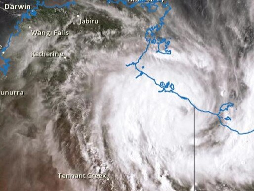
EX-TROPICAL Cyclone Esther is drenching parts of the Top End with up to 160mm of rain as it continues moving inland today
Northern Territory
Don't miss out on the headlines from Northern Territory. Followed categories will be added to My News.
UPDATE: EX-TROPICAL Cyclone Esther is drenching parts of the Top End with up to 160mm of rain as it continues moving inland today.
The Bureau of Meteorology said the low has dumped about 160mm of rain on the McArthur River mine and 131mm on Borroloola since 9am on Monday.
Forecaster Rebecca Patrick said there was a severe weather warning in place for the Northern Barkly and Carpentaria districts, which are experiencing heavy rainfall and damaging winds today.
Ex-tropical cyclone Esther has transitioned to a vigorous tropical low, and will continue moving westward through the Northern Territory, bringing heavy rain, damaging wind gusts and abnormally high tides. For the latest #CycloneEsther updates, refer to https://t.co/AWJKLhynnl pic.twitter.com/t2YFLBNJ15
— Bureau of Meteorology, Northern Territory (@BOM_NT) February 24, 2020
“At the moment ex-cyclone Esther is moving westward across the Carpentaria district, about 90km south of Borroloola, towards more central parts of the Territory,” she said.
“There is also a strong wind warning in place for the Roper Groote coast area which we’ll expect to ease off today.”
EARLIER: Ex-Tropical Cyclone Esther has weakened into a “vigorous topical low” which is expected to drench the Top End as it moves west over land.
The cyclone was officially named at 4am on Monday and crossed the coast in the Gulf of Carpentaria near the NT and Queensland border as a category one system. It weakened overnight into a low.
The Bureau of Meteorology said the low will continue moving westward through the Northern Territory, bringing heavy rain, damaging wind gusts and abnormally high tides.
Tropical #CycloneFerdinand has developed well off the WA coast in the Timor Sea.The Category 1 system will remain offshore with no significant impacts expected for WA mainland. For current info: https://t.co/TH6oLaVUjz @BOM_WA pic.twitter.com/VJrmN7j34d
— Bureau of Meteorology, Australia (@BOM_au) February 24, 2020
BoM forecasters have issued a flood watch for the Barkly and Carpentaria rivers, with rain expected to be dumped on the region in the coming days.
Bureau forecaster Bradley Woods said over the next few days the northern parts of the NT should expect rain.
The parched northern parts of the Barkly are forecasted to see 30-80mm Tuesday and up to 150mm total as a result of ex-Cyclone Esther.
South of Tennant Creek though won’t see much rain.
Above: Facebook video by King Ash Bay Service Station & Supermarket
“Unfortunately south of Tennant Creek there won’t be much rainfall. We’re likely to see more isolated storms in southern parts,” Mr Woods said.
Darwin could experience monsoonal conditions from Thursday with significant rainfall expected.
“As that low tracks west we’re expecting it to move into the Carpentaria district and then into the Gregory district later in the week,” he said.
The centre of #CycloneEsther is currently crossing the coast near the NT/Qld border. For the latest updates, refer to https://t.co/TCPXnGhGaV pic.twitter.com/VUYUoyqAXT
— Bureau of Meteorology, Northern Territory (@BOM_NT) February 24, 2020
“As that system moves into the Gregory district we’re expecting that rain to move further west, that includes western parts of the Top End including Darwin.”
Ex-tropical Cyclone Esther could reform for round two late this week when it reaches the Kimberley coast.
“As it emerges off the Kimberley coast there is a chance that it could form into a cyclone again sometime this week or weekend,” Mr Woods said.
Bec McGuinness of King Ash Bay Service Station & Supermarket posted a video to the business’s Facebook page of wild weather on Sunday afternoon.
AMAZING NT News subscription offer: Only $1 for first 28 days
“We have had drizzling rain non-stop since about 1.30am (Monday) and it’s still raining now. 27.2mm recorded at 9am this morning for the past 24hrs,” she said on Monday.
“Hopefully the catchment area gets a lot of rain and gives the McArthur River a good flush.”
”

Top End hotel becomes detention facility
A surge in the capture of illegal fishermen has become something of a windfall for a local Territory Hotel.

15-year-old charged following alleged Darwin Show stabbing
A 15-year-old youth has been charged and another 15-year-old is in hospital after the alleged stabbing at the Royal Darwin Show on Saturday. READ THE LATEST.