
Unpredictable low forecast to become cyclone, may impact coastline, says BoM
Forecasters are watching a tropical low off the coast which is predicted to form into a cyclone and come closer to Australia.

Northern Territory
Don't miss out on the headlines from Northern Territory. Followed categories will be added to My News.
METEOROLOGISTS are watching a tropical low located off the Western Australian coastline, with forecasts it will strengthen to a category one cyclone.
But the Bureau of Meteorology is warning of “uncertainty” in its forecast, with the storm expected to interact with another cyclone – Tropical Cyclone Seroja – in coming days.
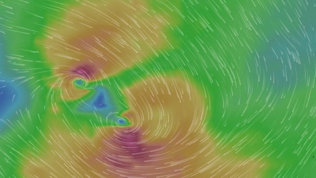
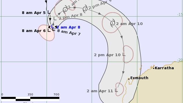
The Bureau’s forecast path also suggests the storm, dubbed 23U, could come close to making landfall along the WA coast between Exmouth and Carnarvon.
It is forecast to be in the region by Sunday, although by then should weaken back to a tropical low.
MORE NT NEWS
Girl punched in face by man in ‘unprovoked’ Casuarina bus attack
“There is the risk of a period of damaging winds and heavy rain developing in the Exmouth area as early as Saturday, even though 23U is unlikely to still be at tropical cyclone intensity by this stage,” the BOM said.
The system, which is expected to intensify into a tropical cyclone late Thursday or early Friday, would still pack gale force winds.
HOT NEW DEAL: Read everything for 28 days for just $1
The range of likely tracks includes the possibility of making landfall between Exmouth and Carnavon.
The storm, known by the BOM by the catchy name of “23U,” will also interact with Tropical Cyclone Seroja.
“There is likely to be interaction between 23U and the approaching Tropical Cyclone Seroja which is expected to limit development of 23U,” the BOM said.
Residents and holidaymakers between Onslow and Jurian Bay urged to prepare for dangerous weather this weekend from Tropical Cyclone Seroja (Cat1) and Tropical Low 23U forecast to become a Cat 1 Friday, when it would be named TC Odette. More info: https://t.co/DXJaxQfuN2pic.twitter.com/cffVxKTJQx
— Bureau of Meteorology, Western Australia (@BOM_WA) April 7, 2021
“The interaction between the two tropical systems means there is a higher degree of uncertainty in the forecast track than usual.”

Matildas players to host clinic in the Top End
Aspiring Territory footballers will get their chance to meet some of their heroes with two current Matildas making the trip to the Top End. Find out how to get involved.

Revealed: Development in Alice Springs baby bashing court case
A court case involving two teens, a horrific home invasion, and baby which had its skull fractured has had a development.