
BOM forecasts tropical cyclone Erroll off Territory coast by Saturday
A tropical low hanging off the Northern Territory coast is expected to intensify into a cyclone as it veers towards Western Australia.
Northern Territory
Don't miss out on the headlines from Northern Territory. Followed categories will be added to My News.
Latest - Saturday, April 12, 11.30am: A tropical low hanging off the Northern Territory coast is expected to intensify into a cyclone as it veers towards Western Australia.
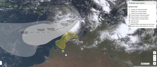
The Bureau of Meteorology warned that a tropical low brewing in the Timor Sea, 255km northwest of the Tiwi Islands was expected to develop into a category 1 cyclone by 4pm, Saturday.
If it does form, the cyclone will be named Errol, and is projected to reach a category 3 storm off the Western Australian coast by Tuesday morning.
The Bureau said as of Saturday morning the weather system was generating wind speeds of up to 95km/h, with the entire system moving southwest at 16km/h.
Strong marine wind warnings have been issued for Beagle Bonaparte Coast and North Tiwi Coast for Saturday, with gales projected for the Beagle Bonaparte Coast on Sunday.
At this stage the cyclone is not projected to make landfall, however communities along the Kimberley coastline from Berkeley River Mouth to Cockatoo Island have been told to watch for heavy rainfall, strong gales and damaging wind gusts over the weekend.
“Increased wind and wave impacts are expected along the Kimberley coast from (Saturday),” the Bureau said.
“As the system moves past, tides between Kuri Bay and Berkeley River Mouth may rise above the normal high tide mark, but the sea level should not exceed the highest tide of the year.”
The WA Department of Fire and Emergency Services has advices communities from King George River to Cockatoo Island to start preparing for dangerous weather and keep up to date with any changes.
This includes securing boats, caravans, trailers, garden sheds, outdoor furniture or any other loose material around homes and workplaces, and checking their emergency kits.
More to come.
Wind warning: Low north of Darwin may become cyclone on Saturday
INITIAL Friday, April 11: A tropical cyclone could form off the Northern Territory’s Top End coast on Saturday.
The Bureau of Meteorology has warned the tropical low north of Darwin is forecast to form into a tropical cyclone, with increasing risk of coastal impacts for the Kimberley coast from late Saturday.
It comes as the Bureau on Friday issued a strong wind warning for the Beagle Bonaparte Coast, North Tiwi Coast and Arafura Coast for across the weekend.
A spokesperson for the Bureau detailed the potential path of Low 29U, most of which will affect northern WA.
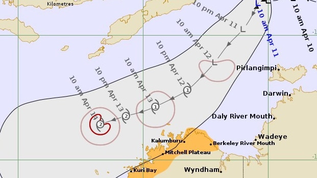
“It is forecast to move southwest, across the Timor Sea over the next few days, while remaining off the western Top End coast,” the spokesperson said.
“Heavy rainfall will possibly develop between Kuri Bay and Berkeley River Mouth, during Saturday evening.
“Heavy rainfall will possibly extend westward and persist between Cockatoo Island and Berkeley River Mouth during Sunday.”
The spokesperson said these areas would also face damaging wind gusts.
The Top End has already had a very wet April, with this system expected to bring even more rain.
To date, rainfall has been 191.4mm — 91mm more than the long term monthly April average of 100.5mm.
But this is still below the 2006 record of 396.2mm.
On April 2, Darwin received 113.2mm of rainfall, more than the monthly average.
Rain is forecast for the next five days in Darwin.


Join the conversation

‘Re-scoped’ Alice art gallery designs unveiled, development application filed
The public have until late August to have their say on a “re-scoped” art gallery proposal in Alice Springs.
Read more

Missing man found safe after five days away
A search for a missing man has ended near Wadeye. See what happened.
Read more