
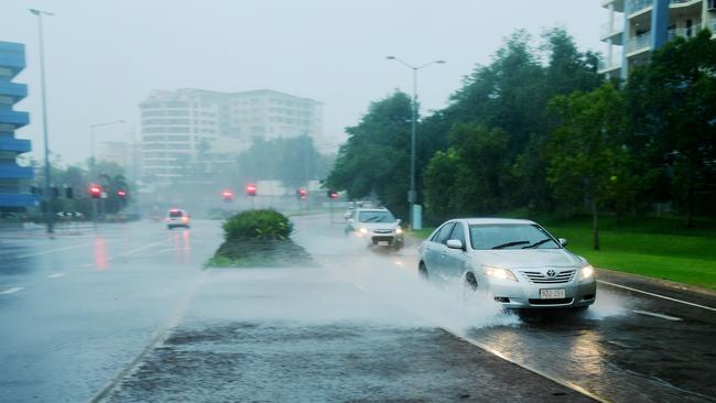
Gale force winds to hit Groote Eylandt Friday, Cyclone Trevor to cross coast Saturday morning
UPDATE: Groote Eylandt will be one of the first places in the NT to feel the effects of Tropical Cyclone Trevor when gale force winds hit this afternoon. Trevor is now expected to make landfall about 10am Saturday as a Category 4 system
News
Don't miss out on the headlines from News. Followed categories will be added to My News.
UPDATED: GROOTE Eylandt will be one of the first places to feel the effects of Tropical Cyclone Trevor when gale force winds hit this afternoon.
The storm is currently a Category 3 system and is expected to intensify to a Category 4 later on Friday.
Very dangerous storm tides with damaging waves are expected to lead to flooding in coastal areas in the warning zone from early Saturday morning.
Tropical Cyclone Trevor has intensified to category 3 in the central Gulf of Carpentaria. A severe impact on the southern Gulf of Carpentaria coast and adjacent inland areas is likely over the weekend. #CycloneTrevor https://t.co/AWJKLhynnl pic.twitter.com/9VvUBYRubU
— Bureau of Meteorology, Northern Territory (@BOM_NT) March 22, 2019
According to the latest information issued by the Bureau of Meteorology, the “very destructive core” of the cyclone will hit the Gulf country on Saturday morning, with wind gusts of up to 275kmh, “strong enough to cause significant damage to vegetation and infrastructure”.
EARLIER: Cyclone Trevor is now expected to make landfall about 10am Saturday as a Category 4 system.
It had previously been forecasted to cross on Saturday afternoon.
Evacuations have now ceased due to the weather deteriorating in the area.
Regional Controller Travis Wurst said there was no need for residents to be evacuated from Groote Eylandt anymore.
However residents will be notified it the situation changes.
He said Groote Eylandt was expected to feel some effects of the cyclone including destructive winds, heavy rainfall and abnormally high tides.
Cyclone Trevor remains a Category 3 system with sustained winds near the centre of 130km/h with wind gusts to 185km/h.
It is estimated to be 230km west northwest of Pormpuraaw, Queensland and 350km east of Alyangula, Groote Eylandt
The cyclone is now moving west southwest at 15km/h.
A Flood Watch has been issued for Carpentaria Coastal Rivers and the Barkly.
Rainfall is expected to increase in the eastern Carpentaria Coastal Rivers from Saturday as Tropical Cyclone Trevor crosses the coast in the south western Gulf of Carpentaria and tracks inland.
Predicted rainfalls of 150-250mm on Saturday and isolated falls to 300mm along the coast, these totals plus more over the following days may result in significant stream rises and localised flooding throughout the Carpentaria Coastal Rivers.
As the rainfall extends inland into the Barkly from Sunday, road conditions may be affected with some communities potentially being cut off.
At home or evacuated, it would have been a tough night for Borroloola residents as tents at Marrara Stadium were flattened by wild weather #TCTrevor @TheNTNews https://t.co/jIrb8Vad8O
— Will Zwar (@zwar_w) March 22, 2019
People are advised to pay attention to emergency alerts, prepare emergency kits, finalise plans and know where the public shelter is.
EARLIER:
Cyclone Trevor is now a Category 3 system intensifying in the hours just before dawn.
The latest Bureau of Meteorology advice says the system has sustained winds near the centre of 130km/h with wind gusts of 185km/h.
Cyclone Trevor is estimated to be 190km west northwest of Pormpuraaw, Queensland and 390km east of Alyangula, Groote Eylandt over the water on the Gulf of Carpentaria.
It is heading west southwest at 14km/h.
MORE >> ARNHEM LAND COMMUNITIES EVACUATED AS CYCLONE TREVOR MOVES IN TO THE GULF OF CARPENTARIA
Tropical Cyclone Trevor will intensify further and should continue its southwest movement across the Gulf of Carpentaria during Friday according to the latest BOM advice.
It is likely to cross the Northern Territory coast on Saturday as a Category 4 severe tropical cyclone.
The latest track map shows the system will cross the border between Borroloola and the NT/QLD border.
A mass evacuation took place on Thursday as emergency services and defence personnel worked to move people into areas of safety.
More than 1200 displaced people have been sent to Katherine and Darwin after they started leaving their homes late Wednesday.
The evacuations were expected to be completed on Friday.
Territory Families youth justice general manager Brent Warren said the Darwin Showground’s Foskey Pavilion had been set up to host hundreds of evacuees along with Marrara Stadium, while a food hall was set up in the Rotary Hall but emergency officers were preparing for a maximum of 2000.
Red Cross is urging Gulf of Carpentaria coast residents in the path of Tropical Cyclone Trevor, to prepare ahead of it making landfall on Saturday.
Red Cross has been activated to manage and provide support in evacuation centres set up in Darwin and Katherine, to temporarily house the thousands arriving from Groote Eylandt, Numbulwar and Borroloola, in what’s being compared to the biggest evacuation since Cyclone Tracy.
MORE >> ALMOST 1000 LEFT BEHIND ON GROOTE EYLANDT AS TREVOR CHANGES PATH
MORE >> ‘THERE WON’T BE MUCH LEFT’: FISHING VILLAGE FEARS THE WORST

Post mortem report awaits in case of 2025’s first DV murder charge
The court case of a man allegedly behind Alice Springs’ – and Australia’s – first domestic violence murder of 2025 is awaiting one key thing. Read the latest from court.

Darwin mayoral candidate’s plans for women’s shed, seniors hub
A sitting Darwin councillor has announced her bid to become the city’s next lord mayor, with promises to build the city into one that is “safe, inclusive and full of opportunity” for everyone. Find out how she plans to make this happen.