
BOM issues flood watch for Tanami, Central and Western Desert, and Sturt Creek District in NT
Rain has hit the Red Centre, as a majority of the Territory is under a Bureau of Meteorology flood watch. Read the latest update from the Bureau.
News
Don't miss out on the headlines from News. Followed categories will be added to My News.
Update, May 27: “Unseasonal rainfall” in the heart of the Territory is expected to last two days, with the downpours triggering a Bureau flood watch.
On Tuesday, an updated flood alert by the Bureau of Meteorology said the Central and Western Desert, Tanani, and Sturt Creek District catchments were on flood watch.
Residents in the area are urged to avoid flooded rivers, streams, drains, and waterways as well as check road conditions before travelling.
On the NT road report, at the time of writing, the Tanami Rd was shut from the end of seal to the WA border.

Within the area, roads may become blocked, communities could be isolated, and waterways and streams could rise, the Bureau alert states.
The latest alert states “unseasonal rain” from a cloud band coming from WA is bringing the downpour to the centre of the Territory.
The heaviest rain is forecast for Tuesday and Wednesday, with conditions expected to ease by Thursday as the band continues to head east, the latest alert states.
It is the third alert issued by the Bureau, the first of which was issued on Sunday.
Another alert will be issued lunchtime Wednesday.
NT told to brace for ‘unseasonal moderate to heavy falls’
Update May 26: An updated flood alert is forecasting “unseasonal” heavy rains for the heart of the Territory, with localised flooding possible.
The alert, the second issued by the Bureau of Meteorology, is warning flooding could happen within the Tanami, Central and Western Desert, and Sturt Creek District catchments.
Heavy rain could fall as early as Monday, the alert states, with the bulk of the rain set to fall on Tuesday, according to the alert.
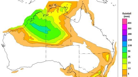
“Widespread rainfall totals of up to 100mm, with isolated totals of up to 150mm are forecast over the Flood Watch area through to Wednesday,” the alert states.
“Stream level rises, localised flooding, and overland inundation are possible in parts of the Flood Watch area, which may affect road access. Some communities may become isolated. Check road conditions before travelling.”
Punters are urged to stay away from flooded streams, drains, rivers, and waterways, and also to prepare for flooding.
The rain band, coming from the west and travelling east, will be “persisting for several days,” the alert said.
Another alert will be issued by the Bureau lunchtime Tuesday.
‘Unseasonal rainfall’ heading into NT triggers BOM flood watch
Initial, May 25: The heart of NT is being told to brace for “unseasonal rainfall” – which could bring isolated totals of up to 150mm – with a flood watch issued ahead of the incoming deluge.
The Bureau of Meteorology issued the flood watch 11am on Sunday, warning localised flooding could be possible in the Tanami, Central and Western Desert, and Sturt Creek District catchments.

The alert comes as a surface trough moves east from WA into the southern half of the NT.
The Bureau alert is predicting “unseasonal rainfall” could come as early as Sunday night.
“Unseasonal moderate to heavy falls are possible from Sunday evening. Widespread rainfall totals of up to 100mm, with isolated totals of up to 150mm are forecast over the Flood Watch area from Monday to Wednesday,” the alert states.
“The highest rainfall is likely to occur on Tuesday.”
The alert is warning roads cold become flooded with communities isolated.
Stream levels could also rise, while areas which are “generally dry” could become inundated with water.
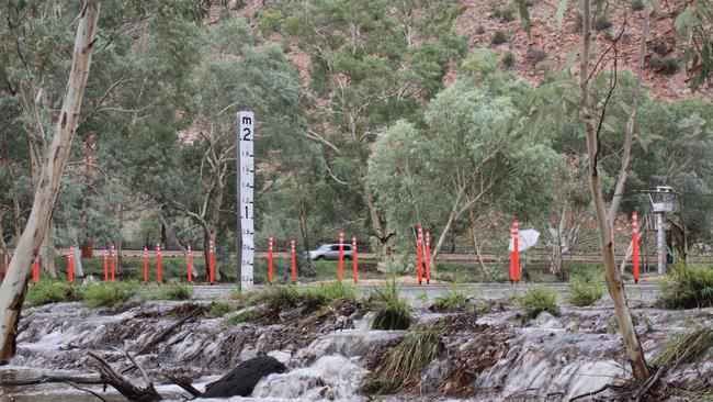
Earlier in the year, rain at the end of March and into April brought a trickle down the Todd River – the usually dry river which runs through the heart of Alice Springs.
The rain came as ex-tropical cyclone Dianne dissipated over the NT.
The alert said the next flood watch will be issued Monday 12.30pm.

Emergency flight for woman with spear embedded in head
A woman with a spear embedded in her head was evacuated by Care Flight to the Royal Darwin Hospital Sunday afternoon.

Hundreds hit the road for Top End Gran Fondo 2025: Picture gallery
Hundreds of cyclists took over the streets of Darwin and surrounds as the Top End Gran Fondo returned for another epic day of two-wheeled action. See all the winners and Photos here.