
Only luck stopped Sydney’s super storms from wreaking destruction across far more of city
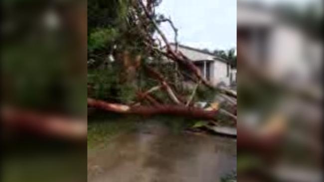
THE damage is in the millions and hearts are as broken as the roofs in Kurnell. But we were lucky that yesterday’s super storm didn’t cause more damage.

Home
Don't miss out on the headlines from Home. Followed categories will be added to My News.
WHAT a difference a day makes. Just 24 hours after a storm whipped up winds the likes of which Sydney had rarely seen, the sun has been shining down on Kurnell today.
It’s hard to believe that not one but two tornadoes careered around NSW and the clean-up cost will run to the tens of millions. But it could have been so much worse, a senior meteorologist has said.
Torrential rain, gusts up to 213km/h and flash flooding caused destruction across Sydney’s coastal fringe yesterday. Yet just a few miles inland, the worst damage many people experienced was a fresh dumping of gum leaves in backyards. It was only due to the fickleness of the winds, however, that the storm didn’t change course and turn its terror on a much larger chunk of the city.
Bureau of Meteorology supervising meteorologist Jane Golding told news.com.au the relatively localised destruction, focused on seaside suburbs such as Cronulla, Kurnell and Bondi, was due to the storm’s makeup.

Sydney effectively experienced two types of storm, she said. A number of larger storms occurred, the hallmarks of which were thunder and heavy rain. But associated with it were two separate tornadoes, which zeroed in on Sydney’s southern suburbs and over the Blue Mountains near Bathurst.
“The bulk of it was sitting out over the water so we caught the edge of it where a tornado spun off the much larger system towards Cronulla and Kurnell,” Ms Golding said.
Storms of the magnitude seen yesterday were not uncommon around Australia, she said, but they needed a “few ingredients” to form, such as the right temperatures and moisture levels.
“They need all those ingredients to line up and yesterday that happened over Cronulla and then only a couple of hours after we received a similar storm complex out towards Mudgee and Bathurst.”
However, the storm was unusual because it formed in the morning. A storm of yesterday’s magnitude forming over land would often take until the afternoon to occur. The unstable conditions out at sea and the ready access to moisture allowed the super cell to take shape far earlier.

Ms Golding said the BoM had been tracking the storm from about 8am and knew it had the potential to be a monster. Yet, in many parts of Sydney, while the skies darkened and the rain fell down, the effects were far less dramatic.
“Tornadoes by their nature are very small. There is a narrow band of damage and destruction that they wreak they are often quite short lived.
“It would have been an extremely different experience a few miles inland,” she said. “There would have been some rain, thunder and lightning but that really damaging phenomenon was a lot closer to the coast.”
While beach suburbs were always going to be at risk from a storm created just off shore, the fact that it didn’t head inland was simply down to luck.

“If the system had of been a couple of kilometres to the west there would have been quite a large area of damage associated with the storm complex,” Ms Golding said.
By the BoM’s estimates one of the storms was at least 25km wide. If it’s eastern, rather than western, edge was on the coast, it would have easily covered Sydney’s CBD, as well as all its inner suburbs. “If that had shifted west it would have covered the eastern third of Sydney from Homebush to the coast. But the conditions were right for it to be over the water, which is why it was there.”
NSW Premier Mike Baird visited residents in the tornado hits suburb of Kurnell today telling them the bill to reconstruct would likely run into the tens of millions of dollars.
“It’s just picked out houses, it’s mowed them down ... all of us are quite in shock on the devastation we’ve seen,” Mr Baird told reporters today.
The Premier praised emergency services and those who had volunteered in the clean-up.
Kurnell resident Kylee McNeilly called on the government to immediately send disaster relief funds to those affected. Ms McNeilly said she had lost the back of her house, with an entire wall ripped off and dumped at her neighbour’s backyard. “We’re struggling, so the government’s got to come and help us,” she said.
— with AAP
Originally published as Only luck stopped Sydney’s super storms from wreaking destruction across far more of city

Popular heaters recalled over fire risk
Fan heaters sold at hundreds of electrical and home stores around the country are being recalled because of fire danger.

Neighbourhood war erupts over ‘$50k’ hedge
Residents of a quiet Melbourne street have found themselves embroiled in a high-stakes showdown with their local council - over a bush.