
New sonar images make stunning discovery after 87 year search
For decades, underwater investigators have desperately tried to solve this 87-year-old mystery. Now, they may have an answer.

It was the groundbreaking flight across the Pacific that ended in tragedy 87 years ago.
Amelia Earhart’s attempt at a round-the-world trip, which was cut short when her plane mysteriously vanished in 1937, has been the focus of countless underwater investigations for decades — with no expeditions returning significant findings as to what happened or where.
But now, a South Carolina team from robotic company Deep Sea Vision (DSV) claim that a sonar image they’ve taken on the ocean floor may have unearthed some evidence that could help piece together what happened on that fateful flight and where the plane went down.
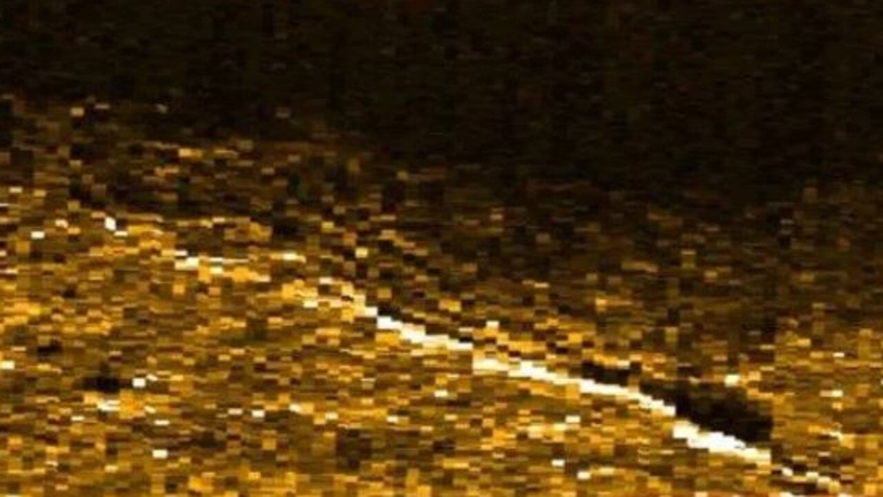
The group of archaeologists and marine robotics experts claim that using sonar to scan the bottom of the ocean has identified an object more than 4877 metres underwater. The object, they say, resembles a small aircraft.
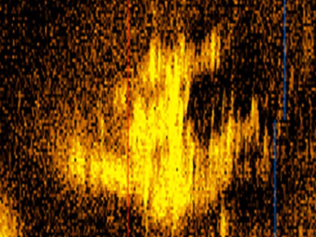
“We always felt that (Earhart) would have made every attempt to land the aircraft gently on the water, and the aircraft signature that we see in the sonar image suggests that may be the case,” DSV CEO Tony Romeo, adding that no one else had scoured the area the image took place before.
Earhart, who was flying a 10-passenger Lockheed 10-E Electra in an attempt to do a lap around the world, mysteriously vanished on July 2, 1937, during a 4000km flight from Lae in Papa New Guina to Howland Island.
Mr Romeo said scouring the area, which is around 161 kilometres from Howland Island, could be one of the biggest steps in solving what he’d argue as one of the “greatest mysteries of all time”.
“Some people call it one of the greatest mysteries of all time, I think it actually is the greatest mystery of all time,” he said, noting this expedition could “bring closure to one of the greatest American stories ever.”


Since the plane’s disappearance, which was also carrying navigator Fred Noonan, speculation into what caused her plane to go down has been debated.
The most plausible is that the small plane ran out of fuel and crashed into the Pacific and as a result, sunk to the ocean floor.
Mr Romeo said that the team hope to return to the site within the next year, with intention to bring the wreckage to the surface if it turns out to be Earhart’s plane.
But with the excitement of the possible discover also come the naysayers, who argue that the image could be anything — even simply “noise in the sonar data”.
“While it is possible that this could be a plane and maybe even Amelia’s plane, it is too premature to say that definitively. It could also be noise in the sonar data, something geological, or some other plane,” Andrew Pietruszka, an underwater archaeologist at Scripps Institution of Oceanography at the University of California, told CNN.
“That being said, if I was searching for Amelia’s plane and had this target in the data set I would want to interrogate it further.”
David Jourdan, the co-founder and president of Nauticos, added that the image produced by DSV also lacks certain features that should appear if it were in fact Earhart’s plane.
“It is impossible to identify anything from a sonar image alone as sound can be tricky and the artefact could be damaged in unpredictable ways altering its shape,” Jourdan said.


“For that reason, you can never say that something is (or isn’t) from a sonar image alone.”
According to DSV, the team spent 90 days searching a total 8370sqm area of the Pacific Ocean floor using a submersible called the HUGIN 600.
The sub has a side scan sonar that has nearly four times the reach of other similar equipment, and won’t reveal the exact location of the findings until further information is examined.
Video of what happens to suitcase in space
A piece of luggage has been shot 40km in to the air and into space, with the whole stunt — including a crash landing — caught on camera.

Reason woman always wears hoodie on flight
A woman has revealed the clothing item she will never fly without, with her clip garnering more than 1.4 million views.
800-year mystery solved at bottom of well
It’s the mystery that’s baffled scientists for centuries, but now — a DNA test may have solved a saga at the bottom of a castle’s well.