
Lost Mayan cities in Guatemala discovered in laser probe of jungle
PYRAMIDS. Palaces. Temples. An incredible ancient Mayan capital — with suburbs of up to 60,000 houses — has been discovered after more than 1,000 years hidden away.
IT’s been there some 1200 years. But it’s been hidden from sight by the dense green foliage of Guatemala’s tropical rainforests.
It’s an ancient Mayan civilisation capable of having housed more than 100,000 people.
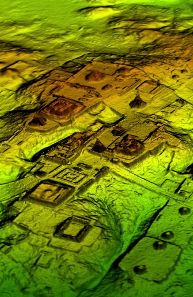
But it took modern laser technology (known as LiDAR — Light Detection and Ranging) and a survey of more than 2100 square kilometres of northern Guatemala’s Maya Biosphere Reserve to expose its existence.
The lasers can peer through the overhanging foliage, sensing what lies beneath.
National Geographic reports the scan has revealed the remains of a long lost nation.

“The LiDAR images make it clear that this entire region was a settlement system whose scale and population density had been grossly underestimated,” says Ithaca College archaeologist Thomas Garrison.
“These features are so extensive that it makes us start to wonder: is this the breadbasket of the Maya lowlands?”
But though the existence of the civilisation is new to archaeologists, evidence suggests it is not new to looters. The survey has revealed thousands of pits dug through the ruins in the search for valuable, portable relics.
REVEALED: ‘Idiot’ driver destroys ancient Peru site
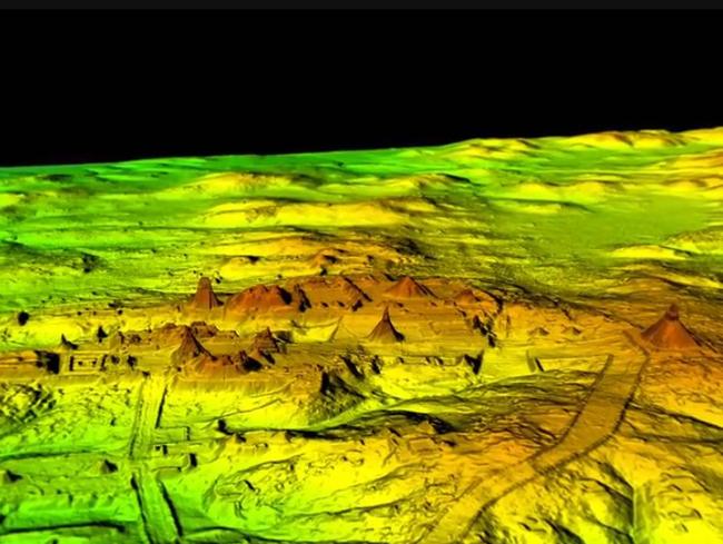
ANCIENT MEGOPOLIS
The vast network of wide highways linked up to four ceremonial cities to settlements, quarries, irrigated farms and other resources. It was all at its bustling peak about 800AD.
The find was announced on Friday by an alliance of US, European and Guatemalan archaeologists working with Guatemala’s Mayan Heritage and Nature Foundation.
The civilisation, which spanned roughly from 250AD through to 900AD, covered an area twice as large as medieval England. But it’s population was significantly denser.
RELATED: The morbid secret of the world’s oldest known temple
The study estimates roughly 10 million people may have lived within the Maya Lowlands, meaning a massive network of food production infrastructure would have been needed.
“That is two to three times more inhabitants than people were saying there were,” said Marcello A. Canuto, a professor of Anthropology at Tulane University.
“With this new data it’s no longer unreasonable to think that there were 10 to 15 million people there — including many living in low-lying, swampy areas that many of us had thought uninhabitable,” archaeologist Estrada-Belli says.
Their descendants still live in the region.
ALL-SEEING EYE
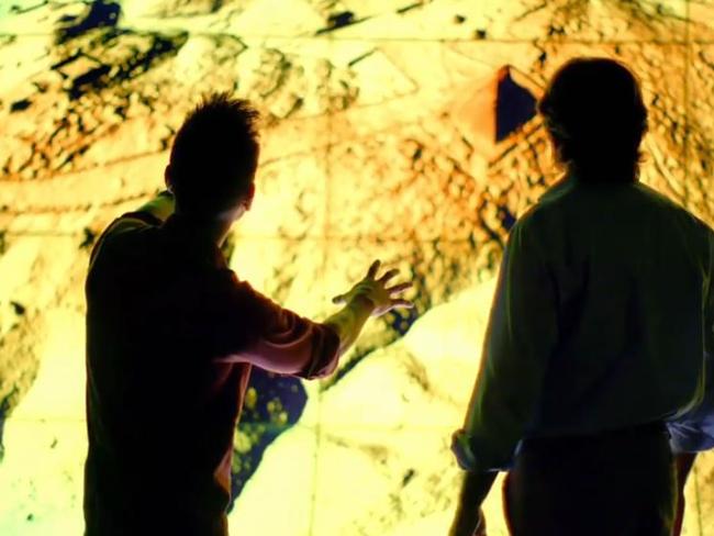
“LiDAR is revolutionising archaeology the way the Hubble Space Telescope revolutionised astronomy,” Tulane University archaeologist Francisco Estrada-Belli told National Geographic. “We’ll need 100 years to go through all [the data] and really understand what we’re seeing.”
It’s a sense of incredulity echoed by University of Calgary Maya specialist Kathryn Reese-Taylor.
“After decades of combing through the forests, no archaeologists had stumbled across these sites,” she told National Geographic. “More importantly, we never had the big picture that this data set gives us. It really pulls back the veil and helps us see the civilisation as the ancient Maya saw it.”
LiDAR view of central Tikal. The relationship between built and natural environments has never been clearer. Tremendous new work we hope to expand in the coming years. In history of Maya archaeology, it’s similar to advent of photography. pic.twitter.com/XIFSmZNbn7
— David Stuart (@ajtzib) February 3, 2018
Aircraft from the University of Houston’s National Center for Airborne Lasder Mapping flew over the terrain in 2016. It took much of last year to process the immense amount of data collected.
The resulting images revealed the Mayans had altered the landscape in a much broader way than previously thought; in some areas, 95 per cent of available land was cultivated.
“This was a civilisation that was literally moving mountains,” Canuto says.
MAYAN REVELATIONS
Among the finds were numerous defensive walls and forts.
“Warfare wasn’t only happening toward the end of the civilisation,” Garrison told National Geographic.
“It was large-scale and systematic, and it endured over many years.”
“Their agriculture is much more intensive and therefore sustainable than we thought and they were cultivating every inch of the land,” said Francisco Estrada-Belli, a Research Assistant Professor at Tulane University.
The mysterious pyramid I found by lidar on a mountain top near Witzna. #losttreasuresofthemayasnakekings #natgeo #pacunamlidarinitiative #pacunam pic.twitter.com/wtCLs30FL3
— Francisco Estrada-B. (@F_EstradaBelli) February 2, 2018
EXPLORE MORE: Secrets of an age of blood and gold
The ancient Mayas partly drained swampy areas that haven’t been considered worth farming since, Estrada-Belli noted. And the extensive defensive fences, ditch-and-rampart systems and irrigation canals suggest a highly organised workforce.
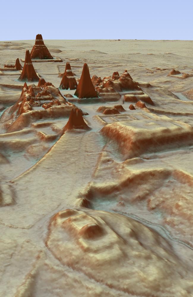
The mapping detected about 60,000 individual structures, including four major Mayan ceremonial centres with plazas and pyramids. It is just the first phase of a three-year project that is intended to map more than 15,000km of Guatemala in the search of further traces of the lost civilisation.
National Geographic will air its exclusive documentary on the discovery in the United States this week.

Stunning mystery of ancient sword revealed
At first glance, it appeared to be just like any other medieval weapon, however the true significance of this sword has since come to light.

Huge Captain Cook find changes everything
The mystery of Captain Cook’s lost ship has finally been solved, ending a 250-year-long search.

Shock find under pyramids stuns the world
Archaeologists are stunned after discovering what they believe could be an ancient city under the pyramids of Giza.