
NYPD reveals interactive New York crime map to show city's most dangerous parts
NEW York might have pizza but there's also a whole world of crime to watch out for. An interactive map from the NYPD shows the city's most dangerous areas.
NEW YORK is supposed to be so great that's why they named it twice. But like every other major city it has a dark underbelly of crime. And now you can see for yourself with an interactive map released by the NYPD that shows the most dangerous parts of the city highlighting where and when major crimes went down.
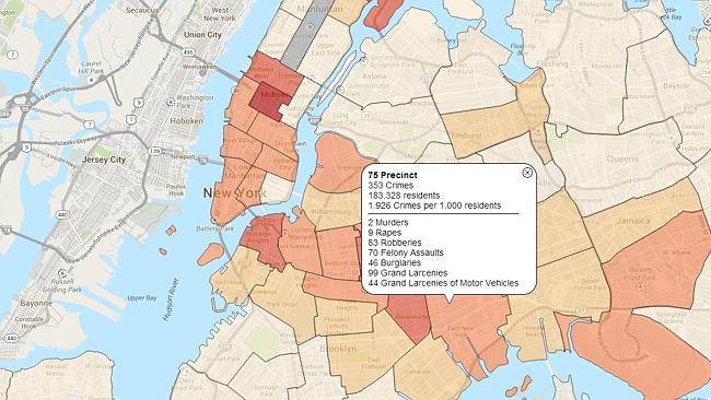
The boys in blue have collected monthly crime data from the seven major incidents of murder, rape, robbery, assault, grand larceny (theft of a person's property), grand larceny of a vehicle and presented it using a clever colour-coded map. Areas most ridden with crime are a darker shade of red.
Crime statistics have been public and available on the NYPD website since 2003 but this new level of graphic information will help residents of New York gain a greater awareness to crime on their doorstep.
"This administration has relied on data to drive its crimefighting, and this map helps enhance New Yorkers' and researchers' understanding of where felony and violent crime persists," said NYPD Commissioner Raymond Kelly.
Going by the month of October we found that the area of East New York was most dangerous with 353 crimes, two of which were murders and nine rapes. Interestingly, Manhattan, which is where tourists flock to, is seen to have some greater levels of crime than many parts of outer lying areas notorious for their high-levels of crime, based on per 1000 residents.
The voyeuristic map allows you to search by individual crimes or as a whole on a month-by-month basis and will update weekly. If you're looking to buy a new property in the Big Apple or perhaps thinking about renting somewhere to stay on Craigslist, this lets you put in a postcode (zip code) to see crimes in a specific area.
While further details are not provided about each individual crime, overall it's a fascinating graphic and might prove to be a useful tool to help keep you safe and out of trouble on your next visit.
Big change coming to Facebook in Australia
Facebook has unveiled a new initiative which it hopes will put a “big dent” in the number of scams that are costing Aussies millions.
Warning over teen social media link
Fresh research revealed in parliament suggests a link between time spent on social media use and mental health in Aussie teens.
Parents’ bold answer to social media ‘cancer’
Parents are begging to raise social media age restrictions even further than 16, warning that “tech companies now own our children”.