
How to make your own Google Street View
GOOGLE lets users go map happy by creating their own Street Views and you won't need to own a self-driving car to do it. We show you how.
GOOGLE'S Street View is a genius piece of mapping that lets you virtually walk anywhere in the world without even needing to leave your chair. The 360-degree virtual computer tour has even been used so we can visit Mount Everest base camp. Now, you can make your own Street View and share anything from your favourite park walk, breathtaking beaches or dodgiest alleys with the world.
To make your own fully-functional Google Street View is actually really simple. Evan Rapoport, Product Manager of Google Maps, explains on a Google blog that what you'll need first is an Android mobile phone or DSLR.
Next, you'll need to photograph the world around you, to create something called Photo Spheres. You'll find this mode on the home screen camera app on Nexus devices running Android 4.2 Jelly Bean which takes several shots designed to be stitched together to form a 'sphere' of images. Using a DSLR you can find a photo stitching software that will do the same job.
HOW TO CREATE PHOTO SPHERES ON YOUR ANDROID MOBILE OR DSLR
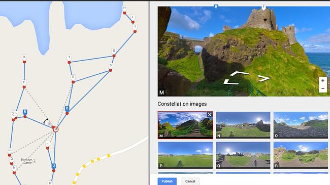
Once you've snapped away the surrounding environment and the Photo Sphere software has stitched them all together you need to share them on Views - a section on Google Maps that has hundreds of panoramas uploaded by users. You can see things like the Grand Canyon or famous beaches here.
If you're logged into your Google account you'll see your profile and your images. Select the ones you want to make a street view with and then connect them together using the new tool.
Once your photo spheres are connected and published, people can navigate between them on Google Maps, just like they could in Street View. That's it. You also even embed your very own Street View in your website.
Google's blog states how excited they are to see "the different types of Street View experiences that everyone will contribute".
"It also opens up a new tool for photographers to showcase diversity in a specific location - by times of day, weather conditions or cultural events - in a way that Street View currently doesn't cover."
"We hope this new feature will enable people to share and witness the beauty and breadth of our planet through Google Maps."

Big change coming to Facebook in Australia
Facebook has unveiled a new initiative which it hopes will put a “big dent” in the number of scams that are costing Aussies millions.
Warning over teen social media link
Fresh research revealed in parliament suggests a link between time spent on social media use and mental health in Aussie teens.
Parents’ bold answer to social media ‘cancer’
Parents are begging to raise social media age restrictions even further than 16, warning that “tech companies now own our children”.