Photo reveals village that shouldn’t exist: Chinese village built on disputed territory in Bhutan
A wolf warrior accidentally tweeted – then deleted – satellite photos that show a model Chinese village. But there’s a big problem.
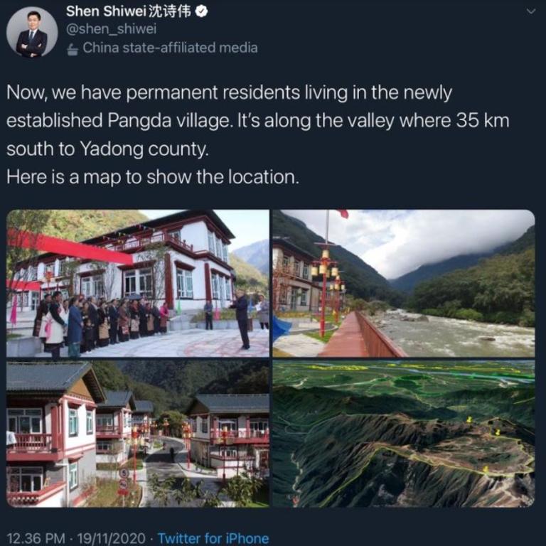
At first it was just another jubilant wolf warrior tweet extolling an outstanding Chinese success story. It was quickly deleted when censors realised it revealed too much.
The Chinese Communist Party (CCP) is making a big deal out of Chairman Xi Jinping’s claim to have eliminated poverty within his borders. Images of happy faces, bright new clothes and abundant harvests are flooding its international social media feeds (even though they’re blocked at home).
The tweet from Beijing-based international affairs analyst Shen Shiwei seemed a perfect fit for the Party-approved mould.
Model Tibetan citizens lined up in ranks wearing State-approved versions of traditional dress. Sparkling new chalets were set in a verdant remote mountain valley. Above it all flew the bright red Chinese flag.
RELATED: China’s major Australian ‘miscalculation’

RELATED: ‘Ready to fight’: China tensions rise
“Now, we have permanent residents living in the newly established Pangda village,” Shen tweeted. That in itself betrays his wolf-warrior status. Only a handful of approved commissars are permitted onto Western social media. Earlier this year, a Chinese citizen was jailed for tweeting a picture of his newborn.
Where Shen went wrong was to add some detail to the boast: “It’s along the valley where 35km south to Yadong county. Here is a map to show the location”.
Readers checked the map.
They checked Google Maps. They compared both to Google’s satellite photographs.
It quickly became obvious there was much more to this village than meets the eye.
Which may be why Shen’s tweet was quickly deleted.
THE VILLAGE
A year ago, Pangda village was little more than a scattering of concrete foundations set on some rubble, perched precariously alongside a seemingly tame mountain stream.
Such streams – intermittently fed by melting mountain ice – can quickly turn angry. An unexpected rise in a similar stream may have contributed to Chinese troops stumbling in their attempt to seize nearby ridges from India earlier this year.
Pangda village sits close to the scene of a similar clash in 2017, when Indian and Chinese troops squared off across the strategically significant Doklam plateau.
The plateau marks a strategic intersection between the borders of India, Bhutan and China high in the Himalayas.
That plateau is right above the new village.
The CCP controlled Global Times reports Tibetan residents moved into the border settlement in September.
“According to open records, authorities in Yadong county of Southwest China’s Tibet Autonomous Region have confirmed that 27 households with 124 people voluntarily moved from Shangdui village of Duina prefecture of Yadong county to Pangda village in September 2020,” it reads.
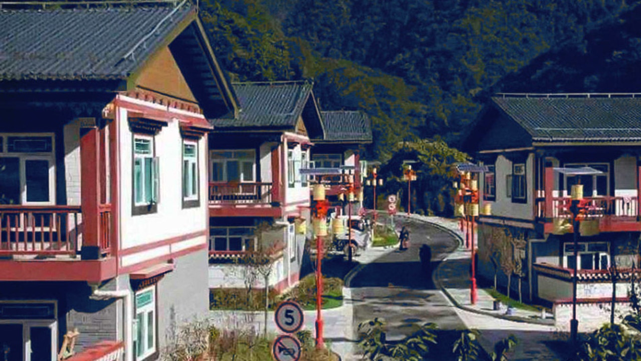
The mountain chalets come with “a public square, village committee, health room, police room, kindergarten, supermarket, and plastic runway”.
Solar panels peek out above stylistic Tibetan street lamps. Lush green lawns and manicured gardens give it a picture-book quality.
“The well-constructed village also showed that China attached great importance to infrastructure building in border villages during the 13th Five-Year Plan period (2016-20), which has greatly improved the living standards of the border residents,” the Global Times declares.
RELATED: America’s brazen move to provoke China

But Pangda’s gleaming facade is concealing something.
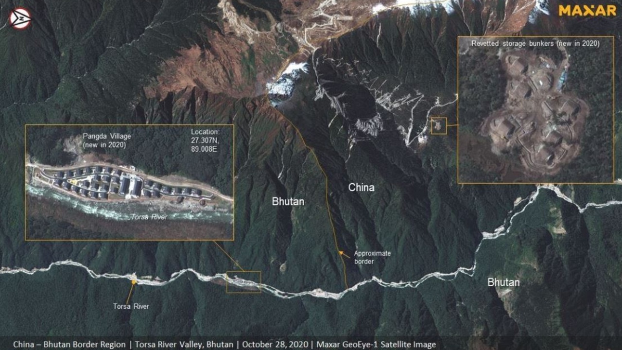
The village is not in China.
OF ICE AND FIRE
“Here’s a CGTN news producer openly admitting that China has occupied and now populated part of a sovereign country,” Australian Strategic Policy Institute (ASPI) open source intelligence analyst Nathan Ruser tweeted.
Here's a CGTN news producer openly admiting that China has occupied and now populated part of a sovereign country. This Pangda village has been constructed (as shown by the included map) ~2.5km beyond Bhutan's international border. China now baselessly claims about 12% of Bhutan. https://t.co/3TxNSffYdJ pic.twitter.com/fEAgWXk7Ln
— Nathan Ruser (@Nrg8000) November 19, 2020
He identifies Pangda village as being a full 2.5km within Bhutan’s borders, near the road which ignited the clash between China and India in 2017.
High resolution satellite imagery from a variety of commercial sources pinpoint where China’s new construction work is located. What isn’t so certain are the borders. They are disputed. But there are tentatively recognised lines of control.
The photos show a new road runs past Pangda village along the bottom of the valley, extending a full 9km into Bhutan. Piles of construction materials indicate further projects are underway.
Indian strategic analysts have since been scouring as many fresh satellite photos as they can get their hands on.
One set, provided by Maxar Technologies, have revealed new hardened ammunition bunkers less than 7km from the 2017 border clash.

“The construction of new ammunition storage bunkers is likely aimed to reinforce the Chinese troops at these bases, allowing them to fight more efficiently if a conflict were to develop at Doklam,” New Delhi based Force Analysis satellite imagery expert Sim Tack told NDTV.
“This is a concerning development, especially following the recent discovery of the Chinese village across the border in Bhutan, and could point to renewed tensions in the Doklam area.”
For his part, Mr Ruther doesn’t hold out much hope for the model village’s future – whatever the diplomatic fire it ignites.
“It’s astounding that anyone would want to live on what is basically a sandbank on the middle of the river in a deep river valley. There’s no way that this village (built for propaganda and occupation) doesn’t flood catastrophically.”
HIGH STAKES
The Doklam Plateau was the scene of 72-days of fighting and tensions in 2017. Indian troops had moved to support Royal Bhutan border troops attempting to block Chinese road-building efforts.
That road was to lead to where it wants its Himalayan border to be – Zompelri ridge – a strategic position overlooking broad swathes of strategic territory. This includes the “Chicken Neck”, a narrow choke-point in India’s supply lines.
Following this exclusive around #Doklam, here's an expanded area visual that covers not #China's encroachment into #Bhutan but also allows a greater understanding of how the sector has been reinforced over time to ensure the PLA's ability in maintaining its "territorial claims" https://t.co/9VSb0T1BrT pic.twitter.com/z8Glw5Cfes
— d-atisâ˜ ï¸ (@detresfa_) November 22, 2020
That road entered what internationally accepted maps define as Bhutanese territory a few hundred metres off its boundary with India. The new road – and its picturesque village – appears to be establishing another route to the same strategic ridge.
“The Chinese have left untouched the 2017 stand-off site, which is located in one corner of Doklam,’’ strategic affairs analyst Dr Brahma Chellaney told India’s NDTV.
“But, step by step, they have been changing the status quo in the rest of Doklam, including by building permanent structures and roads and even setting up villages on a plateau that was uninhabited until three years ago.’’
Beijing claims large – vaguely defined – patches of Bhutan’s northern provinces. Diplomatic and military skirmishes have been ongoing for decades.
Most recently, China objected to an attempt by Bhutan to have a national park in its north granted international recognition. That park is a full 27km behind the established boundary.
And Beijing continues to busily build up its military infrastructure along its disputed borders.
SALAMI SLICING
Bhutan, being nowhere near as large or as rich as either of its feuding neighbours, finds itself in a bind.
Ambassador Vetsop Namgyel told Indian media: “There is no Chinese village inside Bhutan”.
This is despite matching the satellite photos to the official maps presented by the Bhutanese National Statistics Bureau shows it is.
Editor of the Bhutanese newspaper Tenzing Lamsang defended the ambassador, saying the boundaries used by Google’s map browser may be incorrect. “Bhutan has troops on the ground in the said border areas and they would have spotted and reported such matters to Thimphu. No such report.”

Beijing’s media is jubilant:
“Indian media hyped the issue to create the illusion that ‘China is encroaching on Bhutanese territory and bullying the small’ to sow discord between China and Bhutan,” Tsinghua University strategist Qian Feng told the Global Times.
“However, based on Bhutan’s official response, the country has seen through India’s real intentions, and it values its friendly relations with China.”
The maps used by the Global Times to defend its territorial claim are Chinese. They do not recognise conflicting claims – be they in the Himalayas, or South and East China Seas.
The Global Times accused India of ambitions to become the “hegemon of South Asia”. Bhutan has “seen through India’s real intentions, and it values its friendly relations with China” it intones.
Indian media has been equally stoic.
“It is past time for India to call China out on its expansionism in Doklam by pointing out how it is encroaching on the territories of one of the world’s smallest countries,” Dr Chellaney told NDTV. “As Bhutan’s de facto security guarantor, India cannot turn a blind eye to China’s aggressive activities in Doklam.”
Jamie Seidel is a freelance writer | @JamieSeidel


