
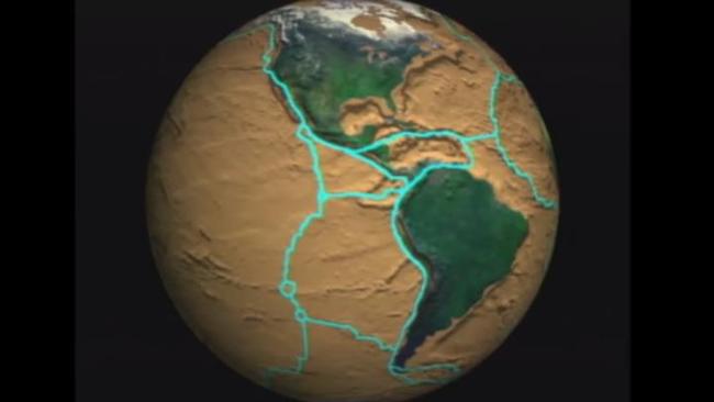
First whole-Earth map fills a 500-million year gap in Earth’s history
A GAP of 500 million years in our understanding of Earth’s history has been solved. This map gives us unparalleled insight into the missing millenia.
EARTH is estimated to be around 4.5 billion years old, with life first appearing around three billion years ago.
To unravel this incredible history, scientists use a range of different techniques to determine when and where continents moved, how life evolved, how climate changed over time, when our oceans rose and fell, and how land was shaped.
Tectonic plates — the huge, constantly moving slabs of rock that make up the outermost layer of the Earth, the crust — are central to all these studies.
Along with a team of researchers from The University of Sydney, The University of Adelaide and Curtin University, geologists Alan Collins and Andrew Merdith published the first whole-Earth plate tectonic map of half a billion years of Earth history — from 1,000 million years ago to 520 million years ago.
The time range is crucial. It’s a period when the Earth went through the most extreme climate swings known, from “Snowball Earth” icy extremes to super-hot greenhouse conditions, when the atmosphere got a major injection of oxygen and when multicellular life appeared and exploded in diversity.
Now with this first global map of plate tectonics through this period, we can start to assess the role of plate tectonic processes on other Earth systems and even address how movement of structures deep in our Earth may have varied over a billion year cycle.
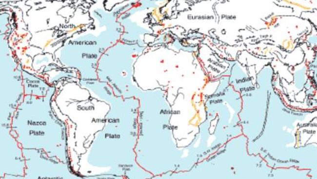
THE EARTH MOVES UNDER OUR FEET
The modern Earth’s tectonic plate boundaries are mapped in excruciating detail.
We now have more details, and a view to way further back in geological time, than were previously available for those studying the Earth.
Using other methods, the latitudes of continents in the past can be worked out, as some iron-bearing rocks freeze the magnetic field in them as they form. This is like a fossil compass, with the needle pointing into the ground at an angle related to the latitude where it formed — near the equator the magnetic field is roughly parallel to the Earth’s surface, at the poles it plunges directly down. You can see this today if you buy a compass in Australia and take it to Canada: the compass won’t work very well, as the needle will want to point down into the Earth. Compass needles are always balanced to remain broadly horizontal in the region that they are designed to work in.
But, these so-called “palaeomagnetic” measurements are hard to do, and it is not easy finding rocks that preserve these records. Also, they only tell us about the continents and not about plate margins or the oceans.
WHY MAP ANCIENT PLATE TECTONICS?
The lack of ancient tectonic maps has posed quite a problem for how we understand our Earth.
Tectonic plates influence many processes on Earth, including the climate, the biosphere (the sphere of life on the outer part of the planet), and the hydrosphere (the water cycle and how it circulates around the planet and how its chemistry varies).
By simply redistributing tectonic plates, and thereby moving the positions (the latitudes and longitudes) of continents and oceans, controls are placed on where different plants and animals can live and migrate.
Plate boundary locations also govern how ocean currents redistribute heat and water chemistry. Different water masses in the ocean contain subtly different elements and their various forms, known as isotopes.
For example, water in the deep oceans was often not at the surface for many thousands of years, and has different composition from the water presently on the ocean’s surface. This is important because different water masses contain different amounts of nutrients, redistributing them to different parts of the Earth, changing the potential for life in different places.
Tectonic plates also influence how much of the Sun’s radiation gets reflected back out to space, changing the Earth’s temperature.
How fast tectonic plates move have also varied over time. At different periods in Earth history there were more mid-ocean volcanoes than there are today, creating water movement such as pushing up ocean waters over the continents. At these times, some types of volcanic eruptions were more frequent, pumping more gas into the atmosphere.
Mountain ranges form as tectonic plates collide, which affect oceanic and atmospheric currents as well as exposing rocks to be eroded. This locks up greenhouse gases, and releases nutrients into the ocean.
Understand ancient plate tectonics and we go someway to understanding the ancient Earth system. And the Earth as it is today, and into the future.
This story first appeared on The Conversation.

State’s $28m AI plan revealed
Company workers aren’t the only ones facing an AI tidal wave, with one state announcing a new $28m drive to embed the tech revolution into its public sector.

‘Hope’: Huge leap in dementia treatment
A breakthrough drug expected to give back years to hundreds of thousands of Australians suffering through a debilitating disease has been approved.
Major update in historic Aussie rocket launch
There’s been a huge update as Gilmour Space Technologies enters its launch window to fire off a rocket into orbit.