
Wild weather, high seas and severe frost to lash Australia
Queenslanders woke to a big shock this morning as snow fell in parts of the state, but not everyone was happy about the rare event.

Severe weather warnings are in place for Australia’s east, as an intense Tasman low and associated cold front brings frigid conditions across Australia.
The huge weather system, stretching for about 1500km across the country’s east coast, is bringing wild conditions from Victoria all the way up to Queensland.
Residents in parts of the Sunshine State even woke up to snow this morning, making it the first time it has snowed in the area since 2015.
Snow has fallen in Eukey and Stanthorpe, but it is not expected to settle.
Icy winds have sent the temperature plummeting, with the apparent temperature in Toowoomba hitting -5C at 6am and -4.4 in Applethorpe at 6.30am.
SNOW IN QUEENSLAND!! â„â„â„
— SNOWSEARCH australia (@SNOWSEARCH_aus) June 3, 2019
Video taken this morning at Alure Stanthorpe!! (luxury couples accommodation at Stanthorpe)
Video: Marion Carrick pic.twitter.com/4vXiaqDnXz
The icy temperatures are not agreeing with locals, with many taking to social media to complain about the weather.
“I’m catching hypothermia as we speak,” one Twitter users from Stanthorpe said.
“It’s freezing, I really don’t want to venture outside, keep warm peps,” another person wrote.
They added: “We are sooks, here in Queensland when the mercury falls, it is freezing, the wind is like ice hitting your face. When I was living in NSW I would often drive to the snow just to roll in it.”
So cold in Eukey, QLD - I’ve got icicles in the hair do. 🥶 @7NewsBrisbane @7NewsAustralia pic.twitter.com/92hoZGd4EQ
— Tristan Vorias (@TristanVorias7) June 3, 2019
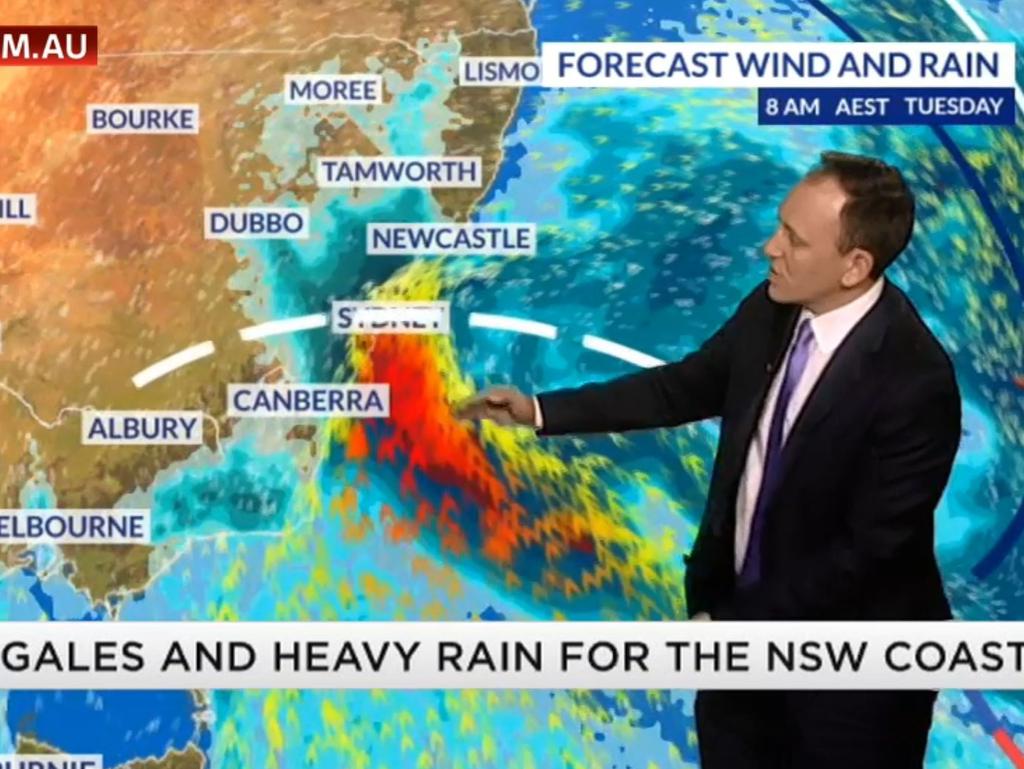
NSW commuters have been warned to brace for unpredictable conditions as gale-force winds, heavy rain and roads “covered in grime” cause chaos on the roads.
A wind gust of 130km/h has already been recorded on the NSW South Coast, with the Bureau of Meteorology warning more gusts of up to 90km/h are expected throughout the day.
Locally destructive wind gusts are possible about the NSW coast during the morning near thunderstorms and heavy shower activity.
An intense cold front continues to move up the coast bringing damaging wind and surf. An 130 km/h wind gust has already recorded at Ulladulla this morning with winds set to increase in the coming hours for eastern parts of Sydney. Warnings current at https://t.co/aFYDXKzNwA
— Bureau of Meteorology, New South Wales (@BOM_NSW) June 3, 2019
Damaging winds are forecast to extend north this morning, moving through the Sydney region around sunrise, and further north by the early afternoon.
Areas most affected by the damaging winds will be the coastal fringes and the higher parts of the ranges.
Sky News Weather chief meteorologist Tom Saunders said while the wild weather would not stick around for a long time, it would have a major impact.
“The strong winds will move away by Wednesday and the rains will ease back to showers along the coastal fringe,” he said.
“This severe weather event won’t be lasting on, but it will be hitting hard.”
Overnight the mercury plunged in Sydney, with the apparent temperature dropping to -0.2C about 4.30am. In the Blue Mountains it dropped to -8C.
The weather system brought chaos to Victoria yesterday, causing havoc on the roads.
The SES had 139 calls for assistance between 7am and 7pm, including 31 incidents of flooding, 56 trees down and 41 cases of building damage.
A severe weather warning is in place for the Gippsland district. Sheep graziers have also been warned to take precautions.
Brisbane hasn’t been immune from the cold weather, with the apparent temperature dropping to just 2.4C at Brisbane Airport this morning.
‘COOL POOL’
Wild weather is expected for the NSW coast today after Melbourne was hammered with rain yesterday.
And Aussies in every part of the country are in for a chilly, rain-soaked week with frost even expected in the southern parts of the Northern Territory later this week.
Sky News chief meteorologist Tom Saunders said temperatures across the country had been below average, even for June.
“A mass of cold air is moving towards the north east of the country. We call this a ‘cold pool’ and that will lead to the formation of a deep low in the western Tasman Sea,” Mr Saunders said.
“It’s been a cold start to winter for much of central and eastern Australia.
“We’re expecting heavy rain in Western Australia later this week to end the state’s dry stop.”
The weather pattern that brought heavy rain in southern Victoria and caused a dumping of heavy snow across the Victorian Alps is now moving up to NSW.
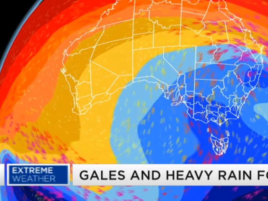
“That low will cause some extreme conditions. Damaging wind gusts are likely up the NSW coast and a band of heavy rain also moving up the coast could cause flash flooding. Because of offshore gales we’ll see huge seas and swells potentially averaging about six metres off the coast.”
By Tuesday night, the worst of the weather will have already moved off the NSW coast but huge swells are still expected up the east coast of Australia.
“Huge swells are forecast, enough to even cause some coastal erosion on Tuesday and Wednesday on parts of the NSW coast,” Mr Saunders said.
Aussies in Victoria, South Australia, Queensland and NSW can also expect very cold southerly winds.
On Tuesday afternoon, temperatures will even drop below 10 degrees in some parts of southern Queensland.
After heavy rain and storms, the mercury at night is going to plummet.
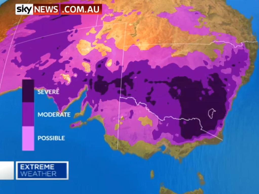
“Cold nights will follow once the winds ease and the skies clear and we’ll have widespread frost,” Mr Saunders said.
“For example, on Wednesday morning temperatures in parts of Victoria and NSW will drop below 5C.
“The frost will be widespread. It will be severe in the alpine region in Victoria by Wednesday morning and there will be patchy frost right through Victoria.
“By Thursday morning, there will be severe frost through southern and central NSW and in northern Victoria. Frost will be widespread throughout South Australia by Thursday morning and even stretching into the south of the Northern Territory.”
Across to the other side of the country, Western Australia is finally going to get some much-needed rain.
Perth just experienced its driest May in 55 years, so thankfully, things are about to change.
Sky News forecasts the “entire west coast” will get significant rain and “cold, wet and windy conditions” on Thursday, Friday and Saturday.
“By Thursday afternoon, a band of heavy rain will move into WA,” Mr Saunders said.
“We could see some flash flooding by Friday morning on parts of the west coast — up to 50mm — and that system will move inland and weaken.
“From this system we could even see some damaging wind gusts and the second front will come through on Saturday and that will bring further showers.
“From the two systems combined, WA will experience easily its heaviest rain in the past few months.”
It’s also going to be very wet in Queensland this weekend with the rain system starting in the north of the state before moving south to the border.
“So good news, we do have rain for many parts of this country coming up in the next week,” Mr Saunders said.
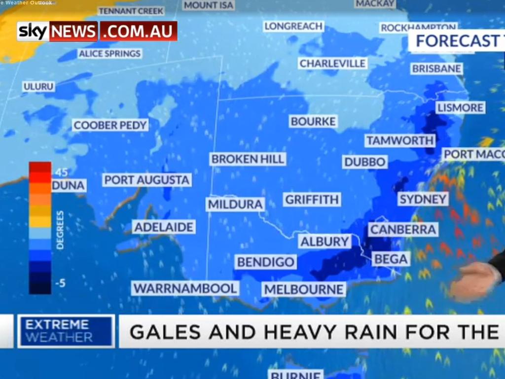
The Bureau of Meteorology earlier issued a severe weather warning stretching 1000km — with wild wind and rain expected to lash large parts of Australia.
Damaging winds of more than 90km/h are expected in some areas affected by the wild weather — which stretches from north of Kempsey in NSW’s Mid North Coast to Eden in the South Coast.
Sky News Weather meteorologist Rob Sharpe previously warned NSW commuters to allow enough time to get to work tomorrow morning due to “tricky” conditions on the roads.
“People will very much notice that change coming through,” Mr Sharpe said.
“It’s really going to bring some powerful winds. We’re worried about wild winds, particularly for that Tuesday morning commute for Sydney and Wollongong.”
A trough associated with a Tasman Low will surge up the NSW coast today and tomorrow, bringing strong to gale-force southerly winds, high seas and much colder conditions. Blizzards may develop about the Alps later today and Tuesday. See https://t.co/xR07DQK0UB for warnings. pic.twitter.com/qatoagkUSX
— Bureau of Meteorology, New South Wales (@BOM_NSW) June 3, 2019
The good news is more snow is expected to accompany the wild weather at slopes including Mount Baw Baw, Falls Creek, Mount Buller and Mount Hotham.
The heavy falls last week led some resorts to open their season a week early but also brought problems.
At Mount Baw Baw, heavy snow knocked down trees and forced the closure of a main road up to the mountain.

ACROSS THE COUNTRY TODAY:
âš ï¸ ðŸ’¨ A STORM FORCE Wind warning has been issued for the #BatemansCoast. Winds can average between 48 knots and up to 63 knots. Slippers should seek more info via Marine Radio. pic.twitter.com/QsZfRNucj8
— NSW Incident Alerts (@nswincidents) June 3, 2019
Sydney (Min 8 Max 17):
Severe weather warning for damaging winds and damaging surf for people in Metropolitan, Illawarra, South Coast, Snowy Mountains and parts of Mid North Coast, Hunter, Central Tablelands, Southern Tablelands and South West Slopes Forecast Districts.
Cloudy. Very high (95 per cent) chance of rain, mostly in the morning. The chance of a thunderstorm in the morning with the risk of heavy falls.
Winds westerly 15 to 25km/h turning south to south-westerly 45 to 65km/h during the morning, reaching 60 to 80km/h about the coast, then becoming south-westerly 30 to 50km/h in the late evening.
Large and powerful surf conditions are expected to be hazardous for coastal activities such as rock fishing, swimming and surfing.
Don't wait until the storm hits - secure items around the house now. Here's the latest BOM update. Severe weather warning #PortMacquarie #Taree #Newcastle #Gosford #Sydney #Wollongong #Nowra #BatemansBay #getready
— NSW SES (@NSWSES) June 3, 2019
read more https://t.co/cSR4cU6x77 pic.twitter.com/ihgGQQX7VO
Melbourne (Min 8 Max 13):
Partly cloudy. Medium (40 per cent) chance of showers.
Winds southerly 20 to 30km/h decreasing to 15 to 20km/h in the evening then becoming south to south-westerly and light in the late evening.
Brisbane (Min 9 Max 18):
Brisk. Winds west to south-westerly 25 to 40km/h.
Perth (Min 7 Max 23):
Sunny. Winds north-easterly 20 to 30km/h becoming light in the late afternoon then becoming north-easterly 15 to 20km/h in the late evening.
Adelaide (Min 9 Max 14):
Cloudy. Slight (30 per cent) chance of a shower in the morning and afternoon. Light winds.
Hobart (Min 5 Max 12):
Cloudy. Slight (20 per cent) chance of a shower in the south in the morning and afternoon.
Light winds becoming south-westerly 15 to 25km/h in the middle of the day then becoming light in the late afternoon.
Canberra (Min 3 Max 11):
Partly cloudy. High (70 per cent) chance of rain in the early morning, then clearing. Winds southerly 30 to 45km/h becoming light in the late evening.
Darwin City and Outer Darwin (Min 20 Max 28):
Partly cloudy. Winds south-easterly 25 to 35km/h.

Millions in path of Aussie ‘bomb cyclone’
Aussies in one state are being urged to prepare now for a powerful “bomb cyclone”, with a major city tipped to cop 200mm of rain within days.

Grim warning for Australia’s east coast
Aussies have been warned to rug up and get their umbrella’s ready as a low pressure system brings a week of frosty conditions.

Icy blast expected in ‘every state’
Winter’s bite is coming in at full force with temperatures forecast to plummet over much of the country – just in time for the school holidays.