
‘We’re only half way through’: East coast smashed by flash flooding and heavy winds
Forecasters become increasingly concerned that even more rain could fall even faster than expected as five people have been rescued from floods.

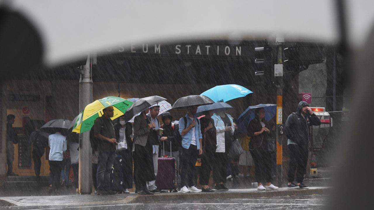
Rain is expected to cause flash-flooding and peak-hour chaos in Sydney this afternoon, with flooding already recorded in high-traffic areas.
The NSW State Emergency Service issued a flood warning for Sydney’s metropolitan areas, saying forecast weather conditions were “likely to cause widespread flooding”.
Flooding has already occurred in Roseville in Sydney’s Upper North Shore and the north-western suburb of Putney, where commuters are advised to allow extra travel time.
#FRNSW crews assisted NSW Roads and Maritime Services to alleviate approx 150,000 litres of storm water flooding at Boundary Street, Roseville.
— Fire and Rescue NSW (@FRNSW) February 7, 2020
If you see flooding, please do not attempt to drive, ride or walk through it. pic.twitter.com/y6bIZJdM9D
Meteorologist have said they are increasingly worried about the unfolding weather event in New South Wales and have “great concerns” that “intense bursts” of rain could see hundreds more millimetres fall far quicker than originally expected.
The sheer amount of rain set to fall is more reminiscent of tropical Queensland than bushfire-stricken NSW.
A total of 683 calls have been received by emergency services following the downpours with five people in NSW rescued from floods. Since the downpours began in Sydney last night, more than 100mm has been registered in the gauge.
In some places, the biggest downpours in almost half a century have been recorded. Roads are clogged, offices flooded and train lines have been blocked.
Meteorologist for the Bureau of Meteorology, Dr Adam Morgan, said multiple areas have already seen their highest rainfall in years.
“By the time the rain ends many coastal areas of northern NSW will have seen their highest rainfall totals since March 2017 and for others in southern NSW since June 2016,” he said.
Over the coming weekend around 300mm of rain could fall along much of coastal NSW. That would be months of rain in just three days.
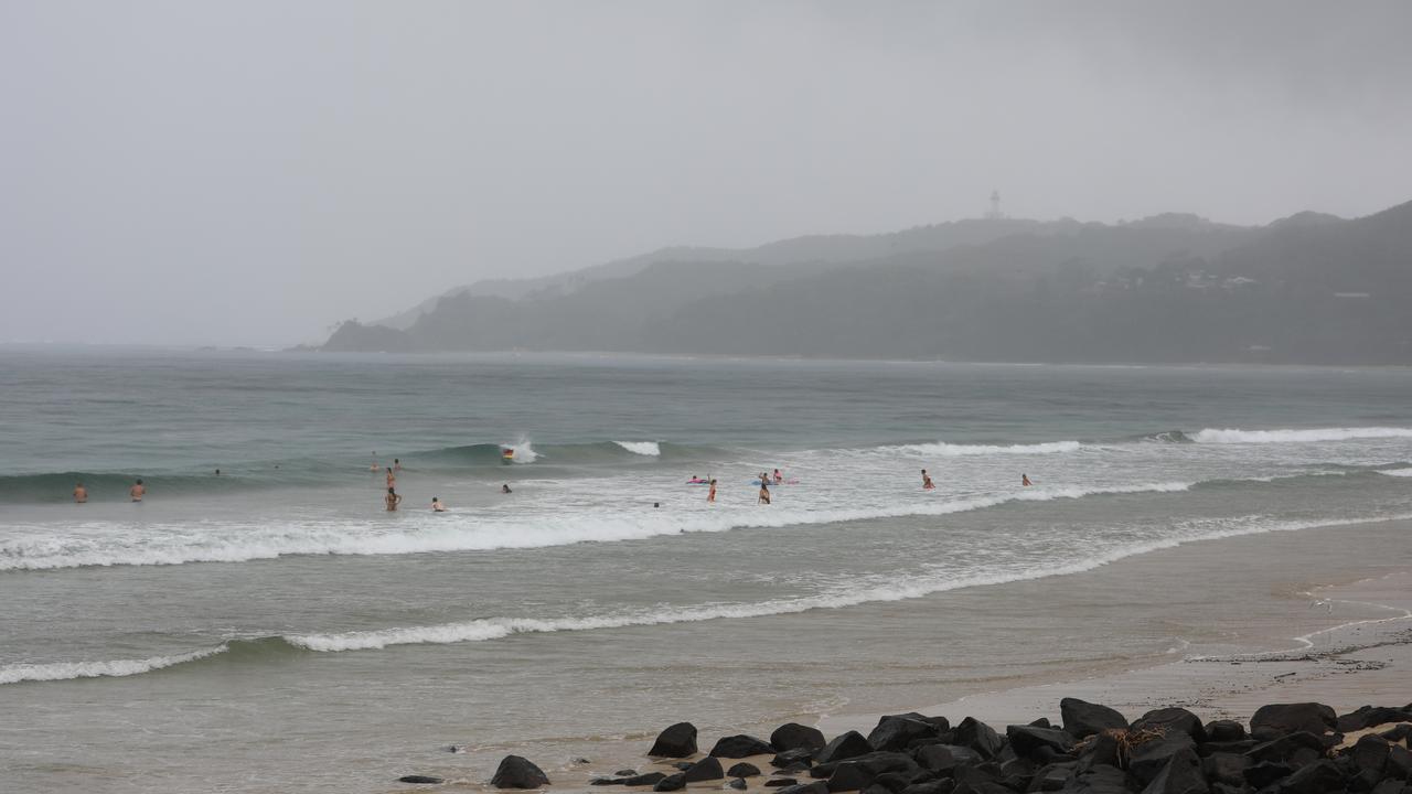
RELATED: Byron Bay floods after receiving heaviest rainfall in almost half a century
RELATED: Heavy downpour causes flash flooding in Sydney
RELATED: Shelves stripped at Coles, Woolworths as Cyclone Damien nears
In the 24 hours to 9am on Friday between 100mm and 200mm fell from the Sunshine Coast to the Mid North Coast of NSW.
Byron Bay saw 283mm, Bellingen had 231mm and Evans Head had 200mm.
“The low pressure trough continues to deepen near the NSW coast, feeding on warm, moist air from the Tasman Sea,” Mr Morgan said.
“An upper trough over southeast Australia is reinforcing the weather system, helping to draw in that humid north-easterly air flow.
“All the ingredients are there for continued prolonged rain, heavy showers and thunderstorms throughout the weekend.”
An urgent weather warning is now in place for a huge 1000km stretch of the coast from Sydney to beyond Brisbane. Authorities have pleaded with people not to drive through flooded roads.
On Friday morning, the Bureau of Meteorology (BOM) issued a severe weather warning for almost the entire NSW coast for heavy rainfall, flash flooding, “abnormally” high tides and dangerous surf.
Meanwhile, in Western Australia, a cyclone is set to hit land as early as tomorrow with supermarket shelves stripped bare and locals preparing to take shelter as winds of 225km/h or higher smash the Pilbara coast.
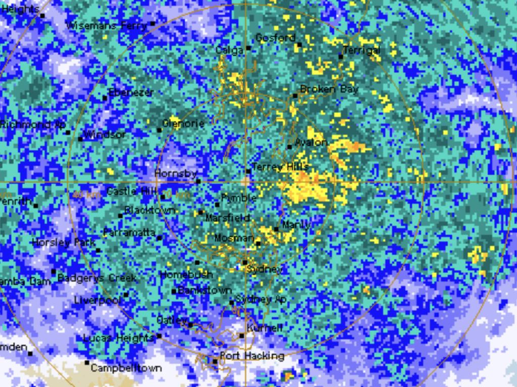
SYDNEY RAIN RADAR
Speaking early this afternoon, the BOM’s Jane Golding said an intense coastal trough had developed over northern NSW, spreading into Queensland, and was now working it’s way south.
“We expect the trough to hang around bringing widespread and prolonged steady rain but there will be intense bursts of rain.
“There are areas of great concern from the NSW Central Coast to the Victoria border,” Ms Golding said.
“It’s not out of the question that's we could get another 200 to 300mm more before Sunday.”
Sydney has been sodden with its highest 24 hour rain total since November 2018, Brisbane drenched and Byron Bay seeing its biggest downfall for almost half a century.
“In some places it will be the equivalent of three months’ rain falling in a week,” Sky News Weather channel Meteorologist Tom Saunders told news.com.au.
“Potentially there could be 24 hour totals up around 200mm and 48 hour totals of 400mm. That amount of rain is massive that far south, it’s what you would normally see in the far north tropics of Australia.”
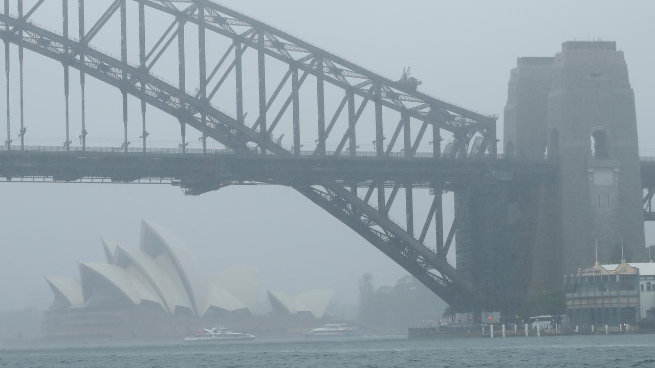
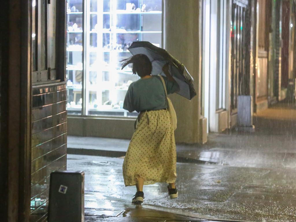
Sydney saw 79mm of rain drench the CBD overnight. More rain has fallen in six hours than has fallen in the last three months combined. The Harbour City could squelch its way through its wettest 24 hour stretch for years today.
“Heavy rain will continue along the NSW coast all weekend. For many regions it will be the heaviest rain in years, including Sydney.”
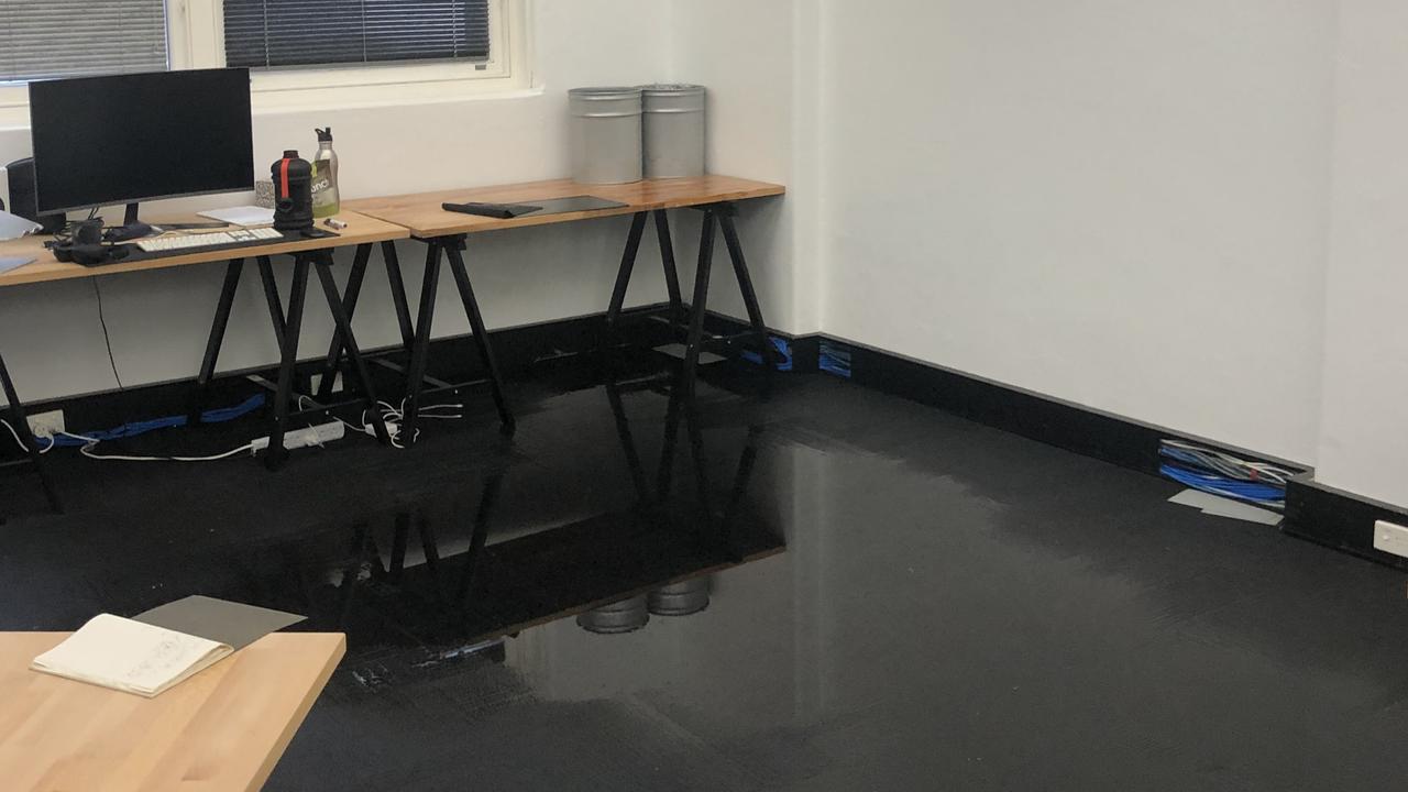
Pictures have shown Sydney CBD offices flooded with water as the rain has seeped into buildings.
By 9am, Byron Bay — the easternmost point of mainland Australia — had received 275mm of rain in 24 hours. That’s a feat not seen for 46 years.
If the BOM’s upper rain forecast is correct, Sydney could see just shy of 400mm of rain over the next week. But 300mm of that could fall by Sunday.
“It is hammering down with rain,” Mr Saunders said.
It’s possible the rain may ease slightly overnight but it will come back again with heavy rain for tomorrow.
“The weekly total will be massive. We’ve already had over 100mm and we will see over 200mm so we’re looking at around 300mm in a widespread area.”
WHAT’S CAUSING ALL THE RAIN?
Flooding has slowed several roads on Sydney’s north shore including Pittwater Rd in Dee Why and Pennant Hills Rd in Thornleigh. The T1 Western and North Shore line suffered delays due to a tree that came down in the soggy conditions. The T2 Inner West and Leppington line was also delayed.
NSW Rural Fire Service Commissioner Shane Fitzsimmons, who has been battling bushfires for months, tweeted this morning that it was, “So nice listening to rain falling last night”.
Sky Weather’s Mr Saunders said the rain could bring drought relief and extinguish some fires.
“The positive Indian Ocean Dipole climate system has broken down and the monsoon is active across the northern tropics.
“Also we have a very moist east north easterly along the east coast which is pumping moisture in from the Coral and Tasman seas. This moisture is linking with a coastal trough to cause the torrential rain.”
Bega and other parts of the south coast have yet to fully feel the rain – but it’s coming. As much as 225mm of moisture could be dumped on areas previously scorched by bushfires. Canberra could get 75mm of moisture.
Brisbane has seen 96mm of rain since yesterday afternoon.
The Courier Mail has reported that major roads are flooded including parts of Gympie Rd at Carseldine and the M1 Bruce Highway at Griffin.
Maryborough on Queensland’s Fraser Coast had received 183mm of rain with the Mary River bursting its banks.
The Bureau now has an urgent warning in place for a 1000km stretch of Australia – from Sydney to Caboolture north of Brisbane. Flooding could occur along rivers up and down the east coast including in major cities.
“We’re only about half way through this event,” Mr Saunders said.
The BOM has said a coastal trough near the coast is bringing increased rainfall.
“This trough is expected to deepen and gradually shift southward, increasing rainfall along the central and southern parts of the coast and adjacent ranges during Friday and over the weekend,” the weather bureau stated.
The NSW Central Coast and south coast are at particular risk.
Heaviest rain in years fell across northeast #NSW overnight. By 8am: #Byronbay 272mm - heaviest rain in 46 years#Evanshead 199mm - heaviest in 3 years#Ballina 177mm - heaviest in 4 years#Coffsharbour 123mm - heaviest rain in 3 years
— Thomas Saunders (@TomSaundersSNW) February 6, 2020
So nice listening to rain falling last night & driving with windscreen wipers on for a change this morning. @BOM_NSW indicates continued rain this next week & importantly, falls across our fire areas which will be so welcomed by our farmers, fire fighters & all affected. #NSWRFS pic.twitter.com/gJ3aFRQlzF
— Shane Fitzsimmons (@RFSCommissioner) February 6, 2020
“Heavy rain resulting in flash flooding along the coast is a real possibility,” NSW SES Deputy Commissioner Daniel Austin said earlier this week.
“Flash flooding is incredibly dangerous. I’m urging motorists, please stay safe on the roads – pull over if the rain becomes too heavy or if you can no longer see where you are going. Make safe decisions and never enter floodwaters.”
In Brisbane, where many suburbs picked up over 100mm of rain yesterday, heavy rain will continue for the next few days. More than 200mm could fall in the coming seven days.
“Over the next eight days we expect 100-300mm on top of what we’ve already had on the NSW coast, up to around 50-100mm for the top of the Ranges and then less than 50mm west of the Ranges,” Sky’s Mr Saunders said.
CYCLONE DAMIEN APPROACHES
As the humid easterly pumps moisture into Queensland, a trough into the west is pushing showers down as far as Victoria and even parts of South Australia. But Melbourne, Adelaide and Perth should remain mostly dry.
Sydney is heading for a maximum of 23C on Friday, Melbourne 26C, Brisbane 29C, Perth 30C, Adelaide 31C, Hobart 20C, Canberra 23C and Darwin 34C.
Meanwhile, Tropical Cyclone Damien is due to make landfall in Western Australia’s northwest Pilbara region over the weekend, with heavy rainfall and flooding expected.
By the time Damien hits land it could be as strong as a category 4 storm. It’s track has it currently on course to hit land just north of Karratha on Saturday.
Read related topics:Sydney

Reason housing crisis could get worse
Australians are already facing a shortfall of more than 640,000 affordable homes. There’s one reason that might get even worse.
Read more

Severe frost alert for Aussie farmers
Farmers are being urged to keep their livestock warm as a freezing start to winter puts animals at risk.
Read more

Aussie-first hydrogen servo opens
Australia’s first publicly accessible hydrogen service station has opened, in a huge move towards decarbonising commercial vehicles.
Read more