
Weather forecast: Massive storms hit Australia’s southeast
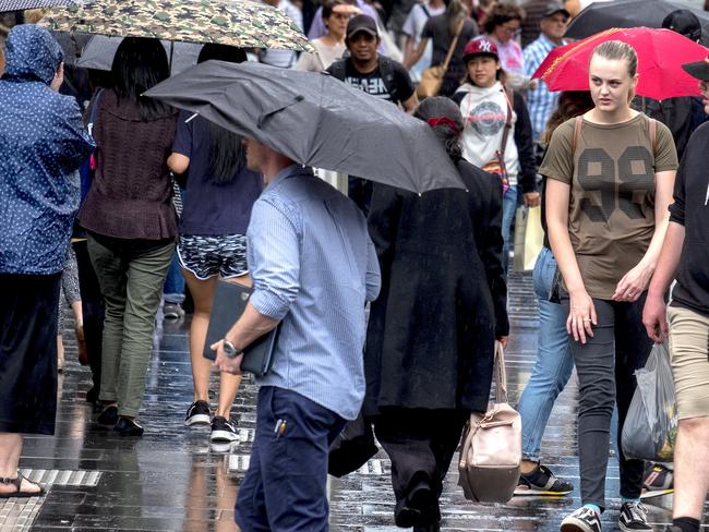
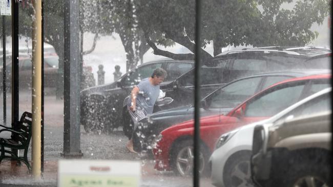
FLOODING has hit Melbourne as storms sweep across the south east. There are warnings more rain and “large hailstones” are due.
VICTORIANS have been warned to expect an “unprecedented” deluge this weekend with severe thunderstorm and flood warnings for the state.
Up to 300mm of rain is expected in the next three days including “large hailstones” and damaging winds with the “worst yet to come”.
Several major events have been cancelled including Taste of Melbourne, Polo in the City, Opera in the Bowl, Arts Centre Melbourne’s outdoor Christmas market, Tennis Victoria Premier League, and all grades of Victorian Premier Cricket.
Qantas flight QF94 from Los Angeles to Melbourne has been diverted to Sydney, with more international diversions expected. Domestically, there are numerous flight delays and some cancellations, with Melbourne Airport urging travellers to check for changes.
So far there have been more than 800 calls for assistance amid rising floodwaters in several Melbourne suburbs.
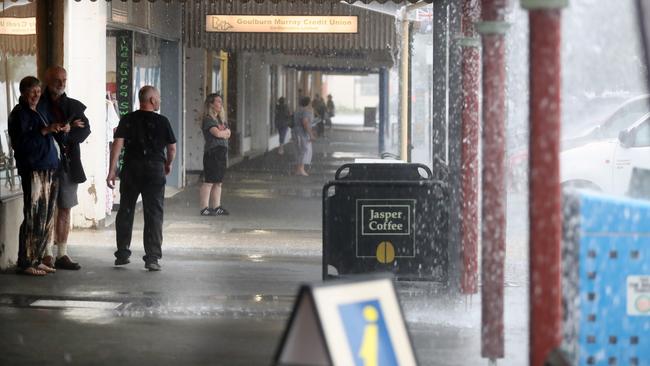
During the Friday evening rush hour train lines and roads were lashed while major stations were sandbagged to protect them from flooding.
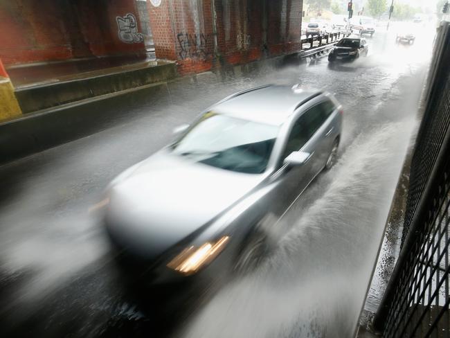
Parts of the Monash and Hume Freeways, as well as roads in the city suburbs of Coburg and Pascoe Vale are underwater as forecasters anticipate a “significant flooding event”. A landslide has caused traffic congestion on the Great Ocean Road, about 6km south of Wye River.
A Flood Watch for #Victoria has been updated. Check here for latest warnings and watches: https://t.co/HLs2UYFQyQ pic.twitter.com/EUIeLjNrJI
— Bureau of Meteorology, Victoria (@BOM_Vic) December 1, 2017
#Rainageddon in Melbourne pic.twitter.com/012z0x9hWH
— David Cabler 🌈 (@DavidCabler) December 1, 2017
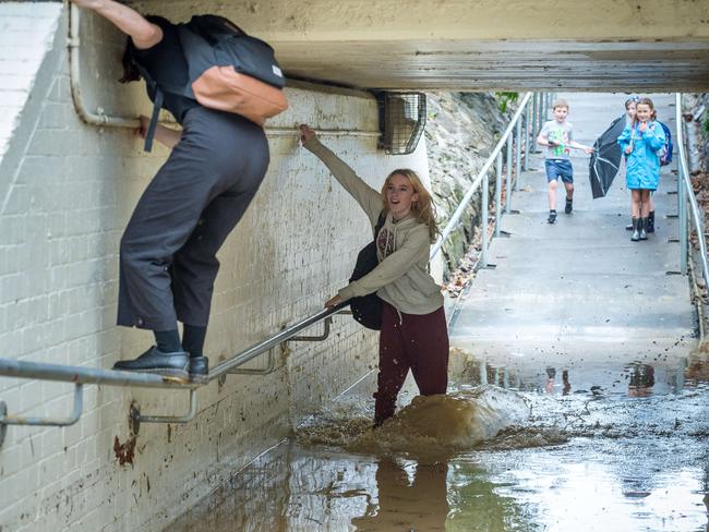
Trains on the Hurstbridge and Melbourne-Albury lines have been suspended after the tracks went under water. Commuters have been told to expect 30 minute delays on services still in operation.
But according to authorities, today’s weather is only part one of two, with the worst of it yet to come.
Premier Daniel Andrews urged Victorians to leave work early if possible on Friday and warned that the state was “going to be very hard hit over coming days”.
Emergency Management Commissioner Craig Lapsley said the storm cell has a lot of life left in it yet.
“This event isn’t just Friday alone,” he said.
“Saturday is the day and the Bureau is very clear (there will be) hundreds of millimetres of rain between north east Victoria.”
He said the north east Victoria region, including Wangaratta, was the area of the biggest concern with “hundreds of millimetres” of rainfall forecast.
“It could go as far as 250mm in the north east,” he said.
“However, it’s widespread rain so don’t underestimate what it means.
“We’ve already seen 30mm of rainfall in the metropolitan area (and) expect overnight to receive another 30-40mm of rain (overnight).”
Mr Lapsley said the Elwood canal, south east of Melbourne, was breaching and “will impact on properties”.
“We’ll have the normal December rainfall in two days.
“It’s coming.”
Belgrave/Lilydale/Alamein and Glen Waverley lines: We recommend all passengers allow extra time for your journeys due to extreme weather - consider delaying or deferring non-essential travel where possible. Thanks for your patience and stay safe.
— Metro Trains (@metrotrains) December 1, 2017
Updated Severe Thunderstorm Warning to include large hailstones - Severe Weather Warning for heavy rainfall still current. Warnings here: https://t.co/HLs2UYFQyQ pic.twitter.com/M516iECA3K
— Bureau of Meteorology, Victoria (@BOM_Vic) December 1, 2017
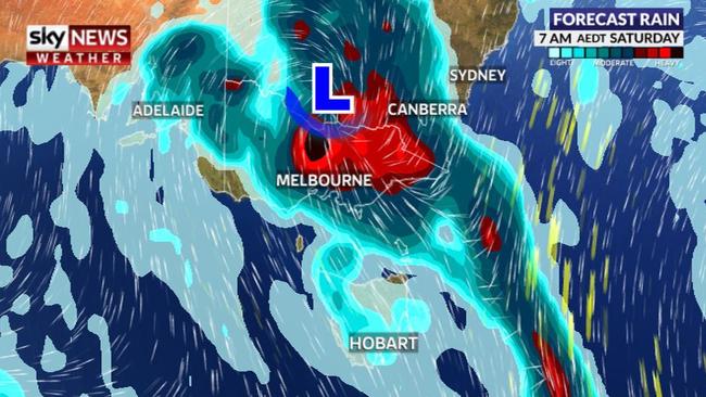
Victoria might be bracing for a “10 out of 10” storm but it’s not the only area in the firing line.
South Australia was drenched overnight and Canberra is anticipating similar conditions over the weekend.
(BoM) has upped the possible upper amount of rain that could fall in Melbourne over the next five days from 150mm to 200mm and warned rainfall records could be broken in parts of the state.
BoM senior meteorologist Scott Williams said: “This is an event of absolute massive scale, half the inhabitants of Melbourne have never ever seen anything like this.”
At least 12 people have already been injured falling from ladders trying to clear their gutters, Ambulance Victoria has said.
However, the Bureau has said the worst of the rain may have shifted east and could spare Melbourne from some excessive downpours.
Less rain than originally expected had crossed the CBD by Friday lunchtime. However, forecasters have warned that any clearing in the rain this afternoon could just be temporary with a trough bringing in more moisture and possible storms overnight and across the weekend.
The real fear is sudden and intense deluges associated with thunderstorms which could give a downpour destructive force. “If you don’t get thunderstorm activity, rainfall could be in the 5-30mm range on (Friday afternoon),” BoM’s James Taylor said on Friday morning.
“But if we get thunderstorm activity, we could easily see up to 50 and even 80mm quite quickly.
“The real risk in Melbourne is the next six to eight hours. A trough will move its way into Melbourne probably around 5-6pm (Friday).”
The #Rain event has started. Ararat collecting the heaviest #December rain in 7 years with 28mm in the gauge. HEAVY RAIN continuing today & tomorrow in #Victoria! @SkyWeatherAUS
— Samantha Chiari (@samanthachiari) November 30, 2017
Away from the city, in the north east ranges, more constant “extreme rain” is expected. Sky New Weather meteorologist Tom Saunders said there would be no respite in the rain for northern and eastern Victoria until about lunchtime Sunday.
The Bureau has issued an unprecedented two-day severe weather warning for heavy rainfall across the entirety of Victoria, with the exception of the south west, as well as southern NSW including Albury, Wagga Wagga and parts of the ACT.
A severe thunderstorm warning for heavy rainfall and damaging winds was this afternoon in place for parts of Western NSW.
Severe thunderstorm warning for heavy #rainfall and damaging #winds for parts of Western NSW, as well as parts of the #Riverina, #CentralWestSlopesPlains, #CentralTablelands, #ACT #SouthWestSlopes, #SouthernTablelands and #SnowyMountains. Details at https://t.co/UMzquLlM8V pic.twitter.com/HTdUgtu7R0
— Bureau of Meteorology, New South Wales (@BOM_NSW) December 1, 2017
Southern NSW could get “more than a month’s rain in 36 hours” and flood warnings are also in place for Tasmania and Victoria as a low pressure trough sweeps through the country’s south.
The heavy rain is due to hit Canberra later on Friday afternoon.
The BoM is predicting showers and thunderstorms this evening with further falls expected overnight after a top of 29C.
Those in the capital can expect between 25-60mm of rain on Saturday, with the rain gauge topping out at as much as 100mm over the weekend and early next week.
Elsewhere, Hobart could get up to 80mm of rain and Brisbane 120mm.
The wild weather has already struck in South Australia, leaving thousands of homes in a blackout. Some 2400 homes were without power in Port Augusta alone this morning, with rainfall records expected to fall, the Advertiser reported.
South Australia’s capital is currently having a break from the rain but more is due.
Victorians have been warned to prepare for a challenging few days with a dozen people already injured even before the rains arrived. Eleven men and one women fell from ladders on Thursday, many while clearing their gutters ahead of the deluge.
The most seriously injured, a man in his 80s, was flown to Melbourne with critical head and spinal injuries after falling near Bendigo.
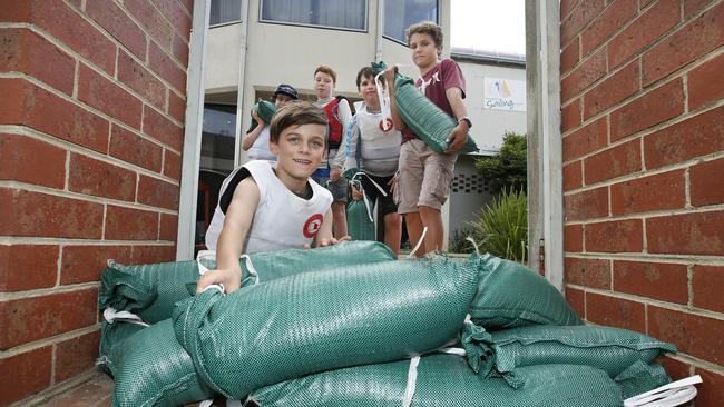
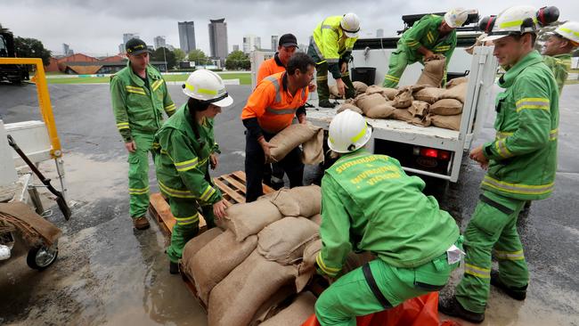
Five hundred State Emergency Services (SES) staff are on standby while major outdoor events have been cancelled. The number one piece of advice: do not drive through flood waters.
Research released today from NRMA Insurance showed a third of drivers weren’t confident of their skills in heavy rain.
“The reality is, it only takes a small amount of floodwater to make even a large vehicle unstable and potentially float away,” spokesman Ramana James said.
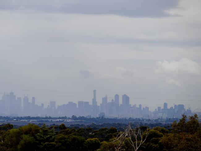
Reader Michael Featherston took the image below from Chadstone, in Melbourne’s southeast, which showed the view of the CBD had all but disappeared as the rain set in just before midday.
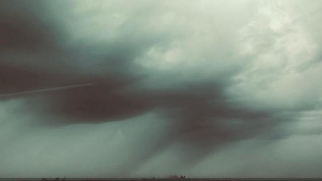
On Thursday, Mr Williams warned much of the rain could come in one dumping, raising flooding fears. “It is an event that poses a threat to life, there will be a massive amount of lightning, there will be roads cut, flood waters,” he said.
“Those thunderstorms will gradually all weld into a massive, great rain band, and that band will spread down across the state on Friday night and Saturday morning.
“This is a vast, intense, high-impact event for this state. I think this event will turn farms into lakes.
“They didn’t think the Titanic would sink, but it did two hours later,” Mr Williams said.
Probably not the best day to hang out the washing. #Melbourne #rain #welcometosummer pic.twitter.com/fwJrcorRiW
— Just David Braue (@zyzzyvamedia) November 30, 2017
BOM says we can expect 100-200mm of rain in the next three days, with up to 250mm in N.E. Victoria.
— Asher Wolf (@Asher_Wolf) November 30, 2017
Melbourne in 1972 when 75mm of rain fell in 20 minutes: pic.twitter.com/VagSlBxay1
Showers have already developed in #Melbourne as a major #rain event kicks off today. Heavy rain, flash floods and thunderstorms all likely today and tomorrow! Live details shortly on @SkyWeatherAUS crossing to @annelisenews shortly!
— Samantha Chiari (@samanthachiari) November 30, 2017
A wet start to summer is expected in the south of the state today. Check the #forecast at https://t.co/KZgSFGDnFM pic.twitter.com/P4Hlw5H9ld
— Bureau of Meteorology, New South Wales (@BOM_NSW) November 30, 2017
Victorian Premier Daniel Andrews has urged the public to stay safe and heed advice from authorities in the coming days.
The Premier also tweeted that Victorians should expect more rainfall in the next few days than in the entire rest of the summer.
1) More rain may fall over the next few days than it usually does in one whole season.
— Daniel Andrews (@DanielAndrewsMP) November 30, 2017
2) Just because it's not bushfire, don't presume it's fine. Flash flooding is extremely destructive and deadly.
— Daniel Andrews (@DanielAndrewsMP) November 30, 2017
SES Victoria’s state duty officer Gerry Sheridan advised residents to take precautions and stay safe.
“It’s been a long time since we have seen a weather event like this, some residents simply won’t be prepared and they need to be,’’ he said.
A rain event of this forecasted magnitude hasn’t been seen in metropolitan Melbourne since 2005 and in regional Victoria since 2010, SES deputy chief Tim Wiebusch said.
Melbourne could receive more than 150mm of rain over a 72-hour period, and up to 300mm in the state’s northeast and alpine districts.
Sky News Weather’s Mr Saunders told news.com.au a complex low pressure system, which is set to deepen on Saturday is behind the weather event.
“A very warm and humid northerly airstream has drifted over southeast Australia and will clash with cold air moving north from the Southern Ocean,” he said.
“Warm air colliding with cold air is a volatile mix and will lead to the formation of a deep and complex low pressure system over southeast Australia on Friday. The low will deepen further on Saturday and lead to torrential rain and dangerous flooding before moving away from the southeast mainland on Sunday.”
Mr Saunders warned this could lead to more than a month’s worth of rain in just a few days across eastern Queensland, NSW and Victoria.
Brisbane’s 120mm would be close to the entire December average of 128.4mm while 100mm in Canberra would be double its usual 53.9mm.
Melbourne usually averages 59.2mm throughout December, a total it is predicted to far exceed in coming days.
Mr Saunders said weather patterns across Australia took a dramatic swing this spring over Australia following the driest September on record for parts of eastern Australia.
He said “rain arrived with a deluge” in October and continued through November, which boosted the seasonal figures to near or even above average for many regions.
“Brisbane has totalled over 250mm by the end of November, the city’s wettest spring in seven years,” he said.
WHEN WILL THE RAIN HIT YOU?
21C on Friday with up to 10mm of rain. Sporadic showers then continue throughout the weekend.
About 200mm of rain could fall on an absolutely drenched Melbourne over the next few days, starting with 25-50mm on Friday and then 30-80mm on Saturday. The mercury will drop, only getting to 14C by Sunday. Persistent falls all weekend.
This has been the hottest November in Hobart since records began. Friday will see the mercury drop by 10C to 23C with up to 20mm of rain. The wettest day is looking like Sunday with up to 10-40mm falling. Highs of just 14C for Saturday and Sunday.
A high of 29C on Friday with storms a possibility and heavy rain. But it’s Saturday that’s going to be really wet with 25-60mm of rain and the dial getting to 24C. Temperatures will then continue to drop further with further, often heavy, rain into next week.
Sydney will escape the wost of the downpours, not a drop will fall on Friday, and temperatures will remain relatively stable at about 27-29C throughout the weekend. But it will still rain, heavily at times, with Saturday the wettest day. Showers will continue into next week.
Queensland will come late to the rain game but it’s forecast to arrive in a big way. A few showers for Friday and Saturday with real downpours arriving from Sunday onwards. Monday could see 25-70mm fall. Temperatures of between 27-29C.
34-35C across the Top End with sunshine and storms with Monday the wettest with up to 25mm of rain.
Never one to play the east coast’s game, Perth will be a model of summertime weather this weekend. Clear skies every day, temperatures will rise from a mild 25C on Thursday to 37C on Sunday.
— with AAP

‘Never seen before’: Shock pics of algal bloom
A federal minister has spoken out about the dead marine life from a toxic algal bloom as new pictures reveal the extent of the devastation.

Albo reconnects with Aussie icon in China
Anthony Albanese has gotten a big dose of panda diplomacy in China, reconnecting with an Aussie favourite as he winds down his state visit.

Greens demand PM act on toxic bloom
As one Aussie state continues to suffer from a “disaster” algae bloom that is putting the future of the fisheries industry in crisis, the Greens have made a simple demand from Albo.