
Weather change could ‘pack some impact’
The east, west and south could all be in for some unsettled conditions with heat spikes, storms and a few heavy and healthy downpours expected.

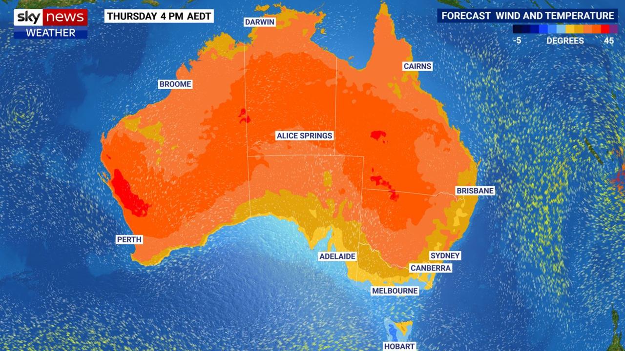
A weather change will “pack (some) impact,” forecasters have said, as the week draws to a close.
That’s the case in the east, west and south,
Where it’s warm, it’ll get scorching and where it’s dry it could well rain as various weather systems clash over south eastern Australia.
While in the west temperatures are set to spike by 10C from one day to the next.
“A high pressure system is reaching across southern Australia from Western Australia,” said Sky News Weather meteorologist Alison Osborne.
“Meanwhile, a cold front is passing through the southeast. That’s bringing some temperature drops, some showers and some possible storms across to the northern part of the country”.
Stream more weather news live & on demand with Flash, a dedicated news streaming service. New to Flash? Try 14 days free now >
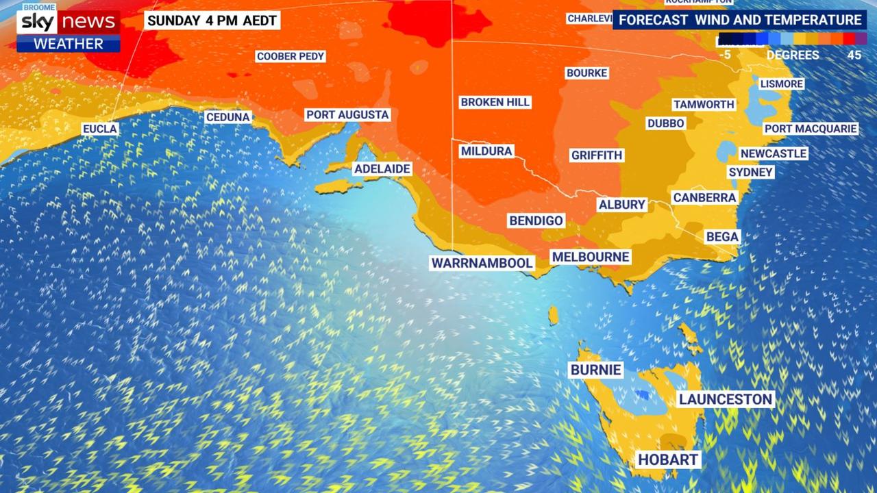
Adelaide is one of the capitals that’s going to see a big hike in the mercury as the week goes on.
A high of 26C on Tuesday will be pleasant enough. That’ll creep up to 29C on Friday and by Sunday the SA capital is looking at a top of 37C. It won’t linger too long however with a drop to 31C on Monday and then into the high twenties.
Minimums in Adelaide will be 14C on Thursday and Friday rising to 22C on Sunday morning. No rain is forecast for the city.
A low intensity heatwave is building over central Victoria and northern and eastern parts of Tasmania for the weekend.
On Thursday, Melbourne will peak at a mild summer high of just 23C with a low of 17C with Friday much the same. Then it will leap to 30C on Saturday and 36C on Sunday. Like Adelaide, little rain.
Head north from Melbourne and it’ll be even hotter. Shepparton is looking at 30C plus highs for the next week including 33C on Saturday, 38C on Monday and almost 40C on Tuesday.
Settling around the low twenties highs in Hobart for the next few days with minimums of 15C on Thursday and just 11C on Saturday. But Sunday could reach 29C. Launceston is likely to crack 30C on Monday and Tuesday with 27C for the weekend.
Canberra will top out at 30C on Thursday then down to mid twenties highs for the weekend before a peak of 31C on Monday. It should remain rain free in the capital.
Minimums in the low teens are on the cards.
Impact of weather change on Sydney
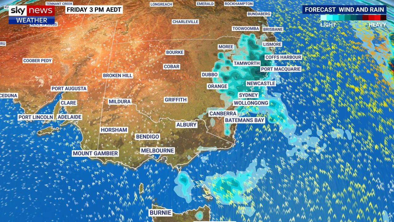
It’s a different story on the east coast as a trough battles the high pressure.
“That cool change could pack more of an impact as it moves through the New South Wales coast,” said Ms Osborne.
“The dry weather is all but gone by late Thursday night and into Friday”.
A high of 32C in Sydney on Thursday with those showers arriving in the late afternoon or evening.
Friday is looking wet with up to 10mm of rain and a 26C high. Thunderstorms are possible both days.
That rain will linger into Saturday but should then clear for the remainder of the weekend with similar maximum temperatures to Friday and 20C lows.
Those wet conditions are likely up and down the NSW coast, east of the ranges and generally getting heavier the further north towards Queensland you go.
Warm and Brisbane with 29-31C highs for the coming days and into next week and minimums of around 20C. Sunny, at least until Saturday when some showers are possible and maybe a rumble of thunder or two.
Stormy with highs of 32C in Darwin with up to 8mm in the gauge most days.
Heat shoots up in Perth
Perth is expected to swelter through a big spike in temperatures.
“A warm northerly wind will see the temperatures jump up to 10C between Wednesday and Thursday,” said Ms Osborne.
That means a high of 39C is possible on Thursday but that will then sink to 31C on Friday. Sunday and Monday could see highs in the mid-thirties.
Overnight lows in Perth will be around 20C most days. A low intensity heatwave is forecast to strike the city and areas north from Sunday.
Kalgoorlie is looking at 40C on Thursday and Friday. Albany shouldn’t get above 26C though in the coming days.
More Coverage
Ms Osborne said the heat was coming straight from the Pilbara. However there was a promising sign.
“It’s been raining in the Pilbara with widespread showers and storms. So the air being dragged south is moisture laden”.
Hopefully that will lessen the likliehood of major bushfires.


