
Wall of rain heading straight for Sydney as cars are submerged in Melbourne floodwaters
The radar shows a big patch of rain is heading toward Sydney, as footage shows cars submerged in floodwaters in Melbourne.

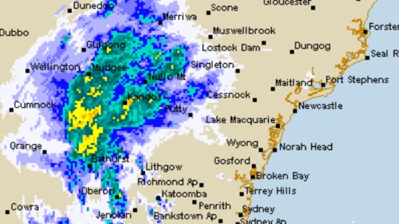
A huge patch of rain is heading toward Sydney, the Bureau of Meteorology weather radar shows.
It comes a day after the city broke the record for the wettest year ever, or at least since records began in 1858, with three months of the year still to go.
Up to 15mm on rain was forecast to fall in Sydney on Friday, with 50 to 60mm tipped for Saturday and 10 to 15mm on Sunday. That is up to 90mm from Friday to Sunday.
NSW Police Force Superintendent Bob Noble urged people in the Hawkesbury-Nepean region not to become complacent on Friday.
“If you’re door knocked and asked to evacuate; we want you to do it then and there, we don’t want you to actually think ‘I’ll do it later in the night’,” he said.
“You need to be on alert. If you are given advice to evacuate, then you evacuate immediately.”
Stream more weather news live & on demand with Flash. 25+ news channels in 1 place. New to Flash? Try 1 month free. Offer ends 31 October, 2022 >
Further south, footage has showed two cars becoming submerged in floodwaters beneath the York Street bridge in South Melbourne as the city copped a drenching.
Wet weather is causing havoc across Melbourne, with two cars becoming submerged in floodwaters beneath the York Street bridge in South Melbourne.
— 9News Melbourne (@9NewsMelb) October 7, 2022
The Bureau of Meteorology is expecting up to 25mm of rain to fall today, with flood warnings issued in parts of Victoria. #9Newspic.twitter.com/AA2bwoZ619
BOM issued a severe thunderstorm warning for parts of Melbourne just before noon on Friday, warning of flash flooding.
Just before 1pm BOM updated the warning to the eastern suburbs of Melbourne, the Mornington Peninsula, the Bass Coast and West and South Gippsland.
By 2pm the severe thunderstorms had moved out of Melbourne and into West and South Gippsland.
‘Feel almost like winter’
Minor flooding has already occurred on the Hawkesbury River in Sydney and the BOM has warned more is possible. The Hunter, which flows through Newcastle, could also burst its banks in places.
A high of 23C on Saturday in Sydney will fall to 17C on Sunday with a minimum of 12C.
Across Friday and over the weekend, Port Macquarie could see around 30mm of rain, Dubbo 80mm, Bourke 60mm and Bega 40mm.
Wollongong is staring down 90 – 130mm of moisture over three very soggy days.
Canberra will see showers and 15-25mm of rain on Friday and then 10 to 15mm is expected on Saturday and 4 to 8mm on Sunday. Temperatures could fall to a maximum of 15C on Sunday and a minimum of 5C.
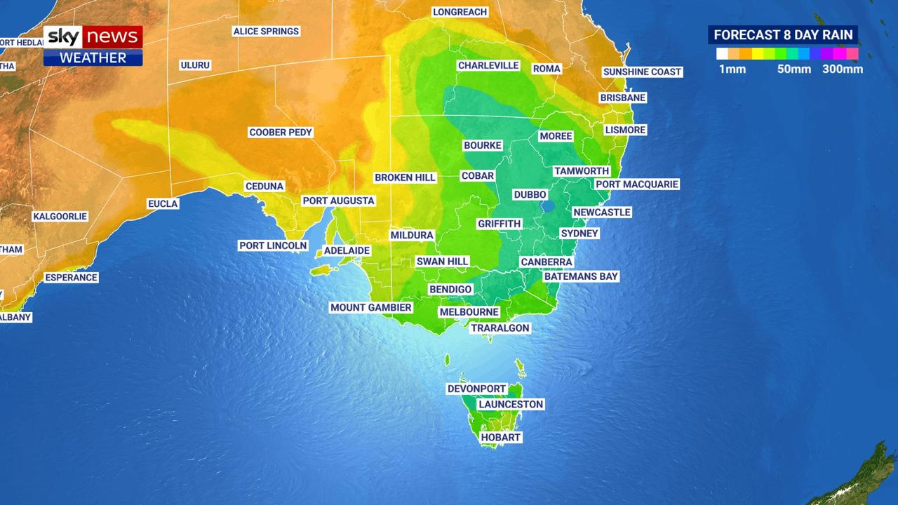
That cold and rainy weather will spread across not just NSW but northern Victoria, southern Queensland and parts of Tasmania too.
“It won’t really feel like spring, it will feel almost like winter,” Sky News Weather meteorologist Rob Sharpe said.
More rain on the horizon
Monday and Tuesday should be dry and mostly sunny in much of NSW, but it won’t last, said the Bureau of Meteorology’s Jonathan How.
“The next system coming through from the west will create areas of widespread rain for mid next week along the east,” he said.
On Monday and Tuesday isolated falls of up to 100mm could potentially hit inland southern Queensland and eastern NSW.
It’s early days still but these weather systems generally move west to east, so coastal areas should see further rain as next week progresses.

PM’s $500m pledge for local jobs
The Prime Minister has announced a crucial investment package during a pre-election speech, but not before he took a few healthy swipes at the opposition.
‘Flesh, fat’: Vile Aussie beach scenes
Locals claim pristine Tasmanian beaches are being overrun by a disgusting “biohazard”, sparking outrage and urgent calls for action.
How PM caused next cyclone to be renamed
The Bureau of Meteorology has had to make a rapid change as two potential tropical cyclones loom off Australia’s coast.