
‘Extraordinary’ conditions as polar air hits
Forecasters have said there could be “extraordinary” and dangerous conditions across the southern states as the coldest weekend in 2021 approaches.


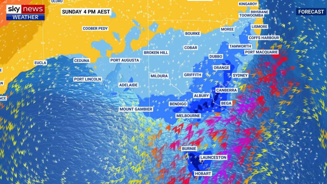
Forecasters have warned of “extraordinary” potentially deadly conditions as a double whammy of severe cold fronts, bringing Antarctic air, bears down on southern states this weekend.
“The last taste of summer has gone. It’s going to be noticeably colder,” Sky News Weather metrologist Alison Osborne said on Friday.
Snow at lower levels, hail, rain and strong winds are all possible.
The first of the two cold fronts has already passed through Victoria with Melbourne peaking at just over 17C on Friday, far chillier than the almost 30C on Thursday.
A second colder front is set to sweep through on Sunday.
The Bureau of Meteorology (BOM) has said another hazard will be huge waves heading to shore from the south west, some as high as 10 metres.
“There is forecast to be an extraordinary increase in wave heights, combined sea and swell, from late Saturday, peaking Sunday morning.”
These could hit much of the South Australian coast, western Victoria and western and southern Victoria.
Rock fishing, boating and ocean swimming are not advised this weekend.
RELATED: Polar blast set to hit southern Australia
Getting colder and colder in southern states
In New South Wales, it will remain warm in Sydney for the next couple of days with a high of 29C on Friday and the odd spell of rain.
But the mercury is set to fall with a maximum of 25C on Saturday and then only just getting into the 20s on Monday with a minimum of a mere 11C.
Canberra will sink to a high of 15C by Sunday. The lows will steadily drop from 11C at dawn on Friday to 5C on Saturday and then -1C on a frosty Monday.
Melbourne’s warm Thursday will be a memory on Friday when 17C will be the max with just 15C on Sunday. Dawn will bottom out at 9C on the weekend. Some showers are likely from Friday until Sunday.
Head inland and those minimums will sink further — a low of just 5C greets Bendigo on Monday morning and just 4C in Wodonga.
The Alps should see snow on the weekend with the mercury hitting -5C.
There is some exceptionally large swell and seas on the way for #Tasmania#Tas this weekend. Pictured is the total wave height for 10am Sunday on Meteye. Keep up with latest warnings, forecasts and Meteye at: https://t.co/zopf5oZwhy? and https://t.co/ZkXK9KAbzfpic.twitter.com/8LkQTjUiEH
— Bureau of Meteorology, Tasmania (@BOM_Tas) April 9, 2021
It will get warmer into the middle of next week but not reach the recent highs we’ve seen.
Across the Bass Strait it gets colder still. Hobart will drift down to just 13C on Sunday. Expect a minimum of 8C on Monday morning. Like Melbourne, showers are likely.
Kunanyi/Mount Wellington, towering over Hobart, could bottom out below zero on Sunday with a dusting of snow over the weekend.
In the Tasmanian Highlands the snow could be far thicker, with 20cm of precipitation possible on Saturday alone at Lake St Clair.
It will be milder in Adelaide but temperatures are still set to fall to 22C on Friday and 19C on Sunday with lows of 12C.

Cyclone concerns in Western Australia
On the other side of the Nullarbor, Perth is more settled in terms of heat, bouncing around 30C until Monday when a high of 24C is expected.
Rain, some heavy, is a possibility for the WA capital on Sunday and Monday.
That’s likely as a result of Tropical Cyclone Seroja, which is building up strength in the Indian Ocean and is expected to turn towards land over the weekend or early next week.
The Bureau of Meteorology has issued warnings for “dangerous weather” including gale force winds, heavy rain and dangerous surf for the WA coast from south of Geraldton to north of Exmouth.
Steady highs of 33C are expected in Darwin with lows of 25C and possible showers on Friday and Sunday.
Brisbane will see 29-31C across the weekend and into next week with mostly clear skies.
Towns lashed by 1m rain in just days
A monsoonal low “more dangerous than a cyclone” is on the move and threatening another deluge for towns that have been smashed with almost 1m of rain in only days.
‘Giant’ hail, supercell storm to smash state
A supercell storm which is forecast to bring “giant-sized” hail and heavy rain is set to batter one Aussie state.
Worst of wild weather yet to come
The worst of the wet weather is yet to come for residents in one state, as several cyclones threaten to develop in the area.