
Rain from Cyclone Ilsa threatening to put dampener on AFL’s Gather round
One of the AFL’s biggest weekends could be in for a soggy time from rains brought on by Cyclone Ilsa in northwestern WA.

The AFL’s newest showcase is facing a monumental challenge from the weather.
The inaugural Gather Round is being held in Adelaide this weekend, but forecast rain from Cyclone Ilsa, which is due to cross into northern Western Australia by Friday, could stretch south, putting a dampener on the big event.
The nine games of round 5 will be played across three venues over four days from Thursday to Sunday for Gather Round, A Festival of Footy.
It’s been dubbed “a never-seen-before celebration of our great game” and will include blockbuster matches, the Pepsi Max Footy Festival, player appearances, live music, street parties and competitions.
The Bureau of Meteorology is forecasting a very high chance of showers for Friday, Saturday and Sunday with heavy falls expected on Saturday in particular.

AFL chief executive Gillon McLachlan said the round was already a success, with more than 190,000 tickets already sold.
“It probably has exceeded expectations; there are people coming from everywhere. I got 20 ticket requests yesterday and it’s building into the weekend,” McLachlan said in Adelaide on Wednesday.
“I think football feels pretty good with why it’s rolling out in South Australia. We’ll talk about that on Monday I’m sure, but I couldn’t be more complimentary about what South Australia have done to make this work.”

Meanwhile, West Australians are on high alert, with Tropical Cyclone Ilsa expected to intensify into a category 3 system within hours.
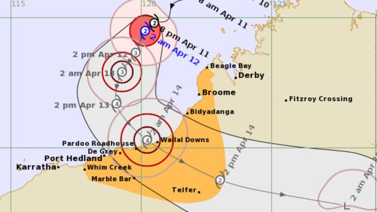
The Bureau of Meteorology forecasts the severe tropical cyclone is expected to reach landfall between Port Hedland and Broome late Thursday or early Friday.
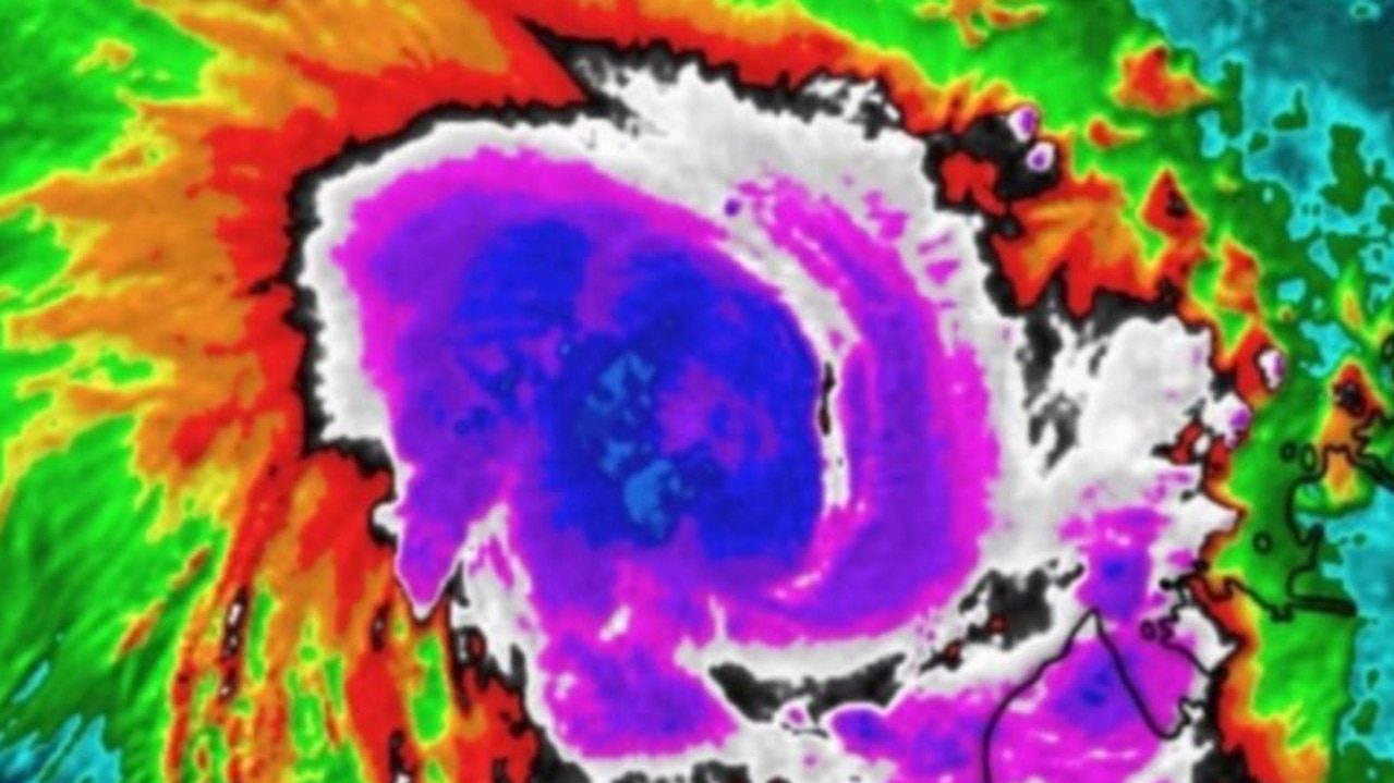
Currently listed as a category 2 cyclone, the system is already recording winds near its centre of 100km/h with wind gusts to 140km/h.
The Bureau forecasts winds could reach up to 300km/h when it reaches the coast.
It is expected to become a category 3 cyclone by Wednesday night before reaching landfall.
The Bureau states there is a “very destructive core” at the centre of the cyclone.
“Extreme gusts up to 270km/h are expected to cross the coast between Bidyadanga and De Grey on Thursday night, and inland to Telfer Friday morning,” the Bureau stated.
Tropical #CycloneIlsa is a category 2 system off the coast of #WA, expected to strengthen into a category 3 system later today. Read the latest Forecast Track Map: https://t.co/LPM2abl9ce
— Bureau of Meteorology, Western Australia (@BOM_WA) April 11, 2023
📷 Tropical Cyclone Ilsa at 7.30 am WST. Red and yellow dots are lightning strikes. pic.twitter.com/cC12TitHTC
Those areas which could be directly impacted include Beagle Bay to Whim Creek, including Port Hedland and Broome, and inland adjacent areas to Telfer.
Department of Fire and Emergency Services Commissioner Darren Klemm said remote Aboriginal communities, pastoral stations, mines and tourism operators in its path had been contacted.
He said DEFS has deployed 26 people to the region, including six emergency service vehicles and SES volunteers who are expected to arrive into Port Hedland on Wednesday.
“We’ve sent additional aircraft into Karratha; that’s two helicopters and one has been retrofitted with the capability to undertake medical evacuation should that be required,” Mr Klemm said.
He urged people in the cyclone’s path to prepare an emergency evacuation kit, including storing “enough food and water for five days”.
The #TropicalLow that was moving slowly in waters north of #WA has developed into #TropicalCyclone Ilsa 🌀The system is expected to intensify into a Severe Tropical Cyclone on Wednesday. We’re bolstering resources in the region to prepare for any impacts: https://t.co/WKZxOEodr7pic.twitter.com/Vn1trRgGbX
— DFES (@dfes_wa) April 11, 2023
Meanwhile, workers at Wallal Downs cattle station, Newcrest’s Telfer mine and caravan parks are being evacuated, along with non-critical workers at BHP’s sites across the region.
Residents in those areas should expect damage to trees, vegetation, any buildings or infrastructure which aren’t up to code, caravans and cars.
“Tropical Cyclone Ilsa is expected to intensify into a severe tropical cyclone Wednesday morning as it continues to move southwest towards the Pilbara coast,” the Bureau stated on Wednesday.
“Ilsa is forecast to track to the south and then turn to the southeast during Thursday, towards the east Pilbara coast.
“A severe impact is likely along the coast and adjacent inland parts between Port Hedland and Broome during late Thursday or early Friday.
“During Friday, Ilsa is forecast to maintain tropical cyclone intensity as it tracks towards Telfer and further inland across the Northern Interior district.”
Heavy rainfall and thunderstorms are expected over the western Kimberley, and may extend to the eastern Pilbara from Thursday and Northern Interior from Friday.
Possible high tides are also forecast for the coast between Broome and Port Hedland during Wednesday and Thursday.
The Bureau warns in some locations the tide may be close to the highest astronomical tide of the year.
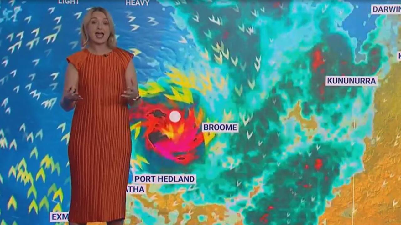
Sky News meteorologist Bradlyn Oakes said the cyclone is currently creating a heavy rain system which has struck land already
“It’s currently bringing quite heavy precipitation to coastal areas; we’re watching those rain gauges continue to tick up,” Ms Oakes said.
“Gusting winds around the centre of this storm system are bringing the potential for storm surges and flash flooding as well as potential for thunderstorms.
“As it continues to make its way across the coastline and then into interior areas of the country, we’re likely to see it intensify to a category 4 storm, which can bring winds over 200km/h which can be quite damaging.”
Thunderstorms forecast for southeast
Meanwhile, residents in the southeast can expect rain and possibly severe thunderstorms across Wednesday and Thursday.
Ms Oakes said the rain began to fall in South Australia on Tuesday night and is expected to make its way across to Victoria and areas in NSW.
“There’s some potential of thunderstorms in the southeast today,” she said.
“The highest risks of those (thunderstorms) being severe are in the southeast corner of South Australia, but there is a chance of severe storms over into Victoria and NSW.
“Those showery conditions are really going to ramp up.”
Read related topics:Weather
Join the conversation

200 species dead in ‘unprecedented’ disaster
Scientists have offered a grim outlook for Aussies hoping for an immediate solution to an ‘unprecedented’ disaster leaving the water at Aussie beaches toxic.
Read more

Australia told to brace for a soaking
Parts of Australia that have already experienced a wet weekend should expect more downpours in the week ahead.
Read more

‘Big’: Wild weather warning to Aussies
Aussies in several states have been warned to brace for a weekend of wild weather, with the risk of floods and damaging winds.
Read more