
Thunderstorms forecast for most of Australia as Melbourne Cup racegoers prepare for rain
A ‘dangerous cocktail’ of humidity and forecast thunderstorms had Melbourne Cup punters on edge.
Forecast wild thunderstorms have stayed away long enough for the Melbourne Cup to be run and won.
Melbourne was also expected to reach a top of 30 degrees, which could mean the hottest Melbourne Cup day since 2005.
The Bureau of Meteorology had forecast a medium chance of showers and thunderstorms during the afternoon and evening for the Melbourne region on Tuesday.
Those thunderstorms could possibly turn severe with winds northerly 25 to 35 km/h decreasing to 15 to 20 km/h in the late afternoon.
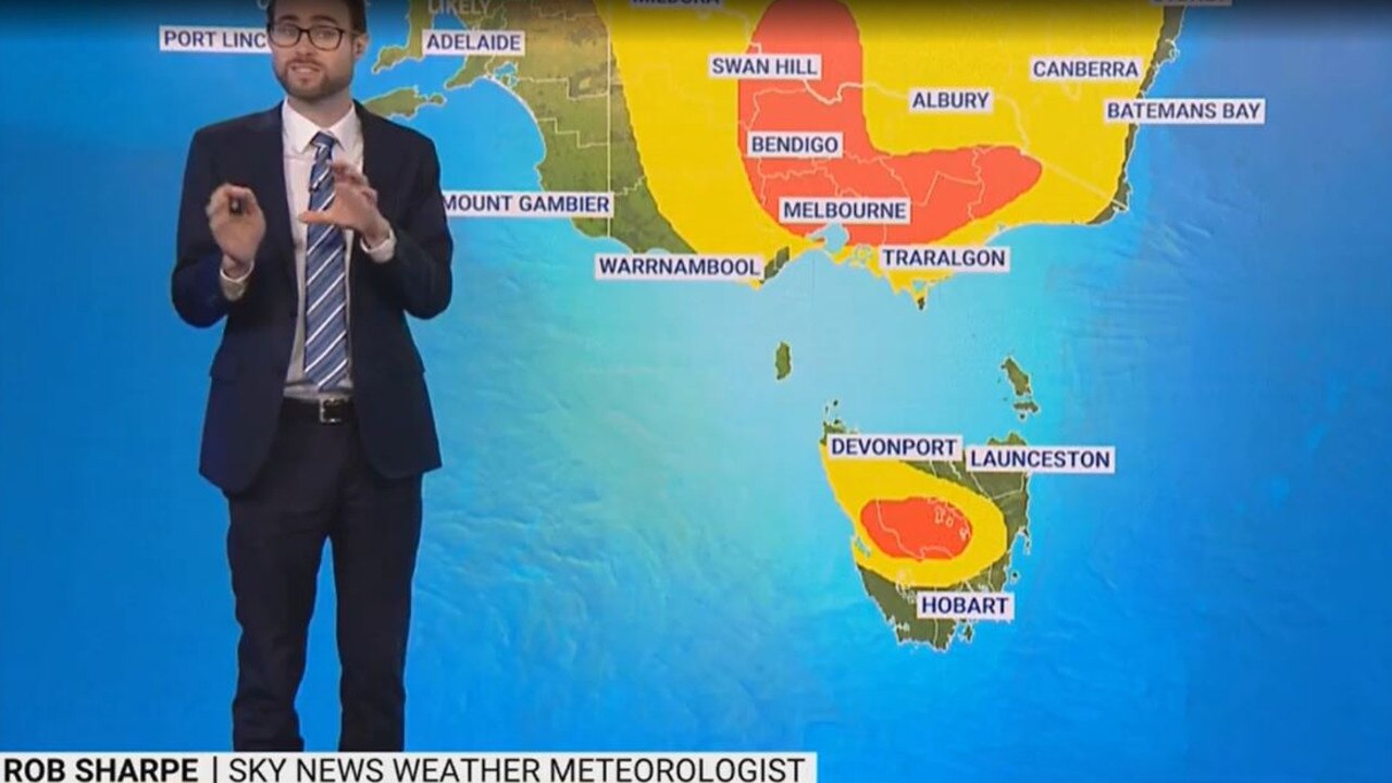
However, Sky News meteorologist Rob Sharpe said Melbourne could still cop a storm, with rain forecast from 2-7pm on Tuesday.
“I don’t think it will quite (thunderstorm) at 3pm in Melbourne at Flemington racecourse, it’s more likely just afterwards, but it is a chance,” Mr Sharpe said before the race.
The rest of Victoria is also facing wet weather conditions as thunderstorms, damaging gusts and large hail develop across the state on Tuesday.
“Through Victoria we see those thunderstorms taking shape,” Mr Sharpe said.
“They started up in morning in the north east in the state.
“It’s a considerable weather risk for this afternoon.”

Melbourne hit a warm 29.8 degrees on Monday, with the warmth expected to continue on Tuesday across the state.
“It’s looking pretty similar (for Tuesday) but add to that the ingredient of thunderstorm activity there’s a bit of a dangerous cocktail for some people across Victoria today,” Mr Sharpe said.
“There’s considerable heat around the country at the moment, warmer than usual across much of south eastern Australia even into Tasmania.
“The little bit of humidity is helping to fuel thunderstorms today.”
The rest of the country is also forecast to have heavy rain and thunderstorms on Tuesday and Wednesday.
A severe thunderstorm warning has been issued for large hailstones and heavy rainfall in the Lower Western and parts of Riverina and Upper Western Forecast Districts in NSW at 2.34pm on Tuesday.
“Every single state and territory today could see thunderstorm activity,” Mr Sharpe said.
“Inland areas are seeing the showers and thunderstorms again and some of those are potentially severe for Queensland and parts of NSW.
“The possible heavy rain could lead to flash flooding with the slow moving nature of those storms.
“Storms are also a chance (of forming) over north west Australia, Central Australia and parts of West Australia as well.”
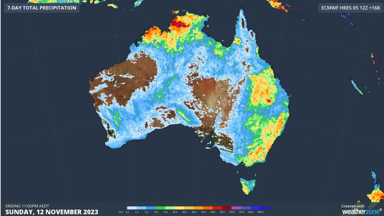
The country is also expected to face “several million lightning strikes” over the coming days, according to Weatherzone.
“This is off the back of a stormy weekend that produced more than one million lightning strikes above Australia on Saturday and Sunday,” Weatherzone said.
The Bureau forecast severe storms in central and southern interior Queensland today, including areas like Barcaldine, Blackall, Longreach and Charleville.
Severe storms in central & southern interior Queensland today, including areas like Barcaldine, Blackall, Longreach, and Charleville. Large hail, strong winds, and heavy rain are major concerns. Widespread thunderstorm activity in other regions. Monitor for warnings âš¡ðŸŒ§ï¸ pic.twitter.com/oaSPRL1tPd
— Bureau of Meteorology, Queensland (@BOM_Qld) November 7, 2023
Large hail, strong winds, and heavy rain are also major concerns for those areas, as widespread thunderstorm activity continues in other regions.
Mr Sharpe said as the week progresses NSW, Victoria and Tasmania will likely be most affected by the thunderstorms.
“The target state is Victoria (on Wednesday), with severe thunderstorms expected to develop and are intended to be bigger than today,” Mr Sharpe said.
“NSW, Victoria and Tasmania will likely start seeing more widespread thunderstorm activity.
“NSW will become the target state for Thursday and Friday.”
It comes as the Bureau released its October rainfall data for Queensland on Tuesday.
Rainfall for #Qld was 83.6% below the 1961-1990 average making the 6th-driest October on record and the driest since 2006. Parts of the south-east experienced their lowest Oct rainfall on record. The mean temp for the state was 1.14 °C above average: https://t.co/t9EaqKqk3apic.twitter.com/kR7LCn0czb
— Bureau of Meteorology, Queensland (@BOM_Qld) November 7, 2023
Queensland recorded 83.6 per cent rainfall below the 1961-1990 average making the sixth driest October on record and the driest since 2006.
“Parts of the southeast experienced their lowest October rainfall on record,” the Bureau stated.
“The mean temp for the state was 1.14 degrees celsius above average.”

Meanwhile, Victoria recorded 69.45mm rainfall in October, which was 7.5 per cent above the 1961–1990 average.
“Mt Hotham was the wettest site overall in the state recording a rainfall total of 331.4mm,” the Bureau stated.
“The mean maximum temperature was 0.52degrees above the 1961–1990 average.”
Read related topics:Melbourne
Join the conversation

Superpest that could terrorise Australia
Read more

Wild pics after storm smashes city
Read more

‘It’s real’: Aussie-made hydrogen flying machine
Read more