
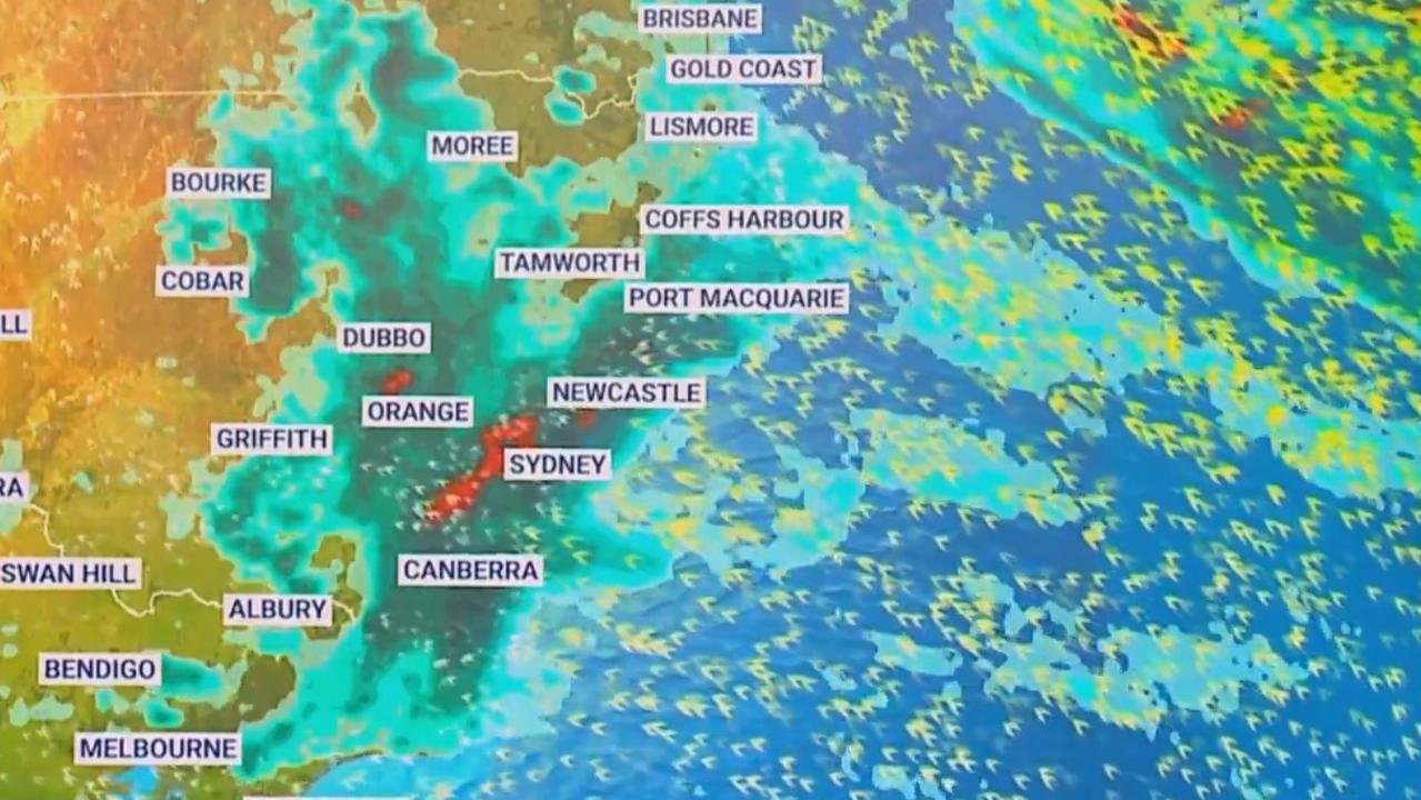
Sydney weather: Up to 500mm of heavy rain, thunderstorms to hit across NSW
A near-stationary wet weather system will see nearly all parts of NSW drenched in a multi-day deluge, with some areas likely to be hit with up to 200mm of rain.

After a short reprieve from wet weather, Sydney and large swathes of NSW are set to be smashed by days of torrential rain.
While Sydney residents have woken up to inclement drizzles, the heavy rainfall is forecast to begin from Wednesday afternoon, along with a danger of flash flooding.
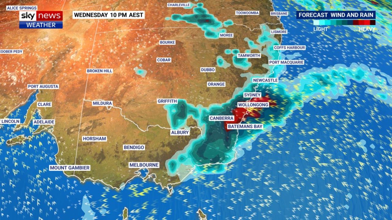
Thursday, however will bring the heaviest rainfall of the multi-day weather event. Some areas could even receive two months’ worth of rain in a day, says Sky News’ Chief Meteorologist Tom Saunders.
“Tomorrow we could see 100mm of rain in the Sydney area, Blue Mountains, Illawarra, down to the Southern Highlands, with localised readings of 200mm of rain,” Mr Saunders said.
“That would be about double the monthly average.”
Currently, the Bureau of Meteorology (BOM) has already issued severe weather warnings for Metropolitan Sydney and people in Illawarra, south coast and parts of Hunter, Central Tablelands and Southern Tablelands areas, with a flood watch in place for 20 districts and rivers.
“The water is falling on exceptionally waterlogged ground and as a result it will run into the creeks and rivers,” Mr Saunders said.
“That’s why there’s an increased threat for riverine and flash flooding.”
âš ï¸ Initial Minor #Flood Warning issued for the #Clarence River. Minor flooding possible at #Grafton early Wednesday morning on the high tide. See https://t.co/AdztI2rqg1 for details and updates; follow advice from @NSWSES. #NSWFloodspic.twitter.com/pREMJhBSJ0
— Bureau of Meteorology, New South Wales (@BOM_NSW) April 5, 2022
Worst to come for monster Sydney storm
Mr Saunders also notes that bar the far-western reaches of the state, like Broken Hill, the rest of NSW will likely be lashed by rains and storms in the upcoming days.
Unfortunately the wet weather is set to continue into April.
“The rain will ease across the weekend, however the indication looks like we’ll be getting another big rain event next week.”
In Sydney, a near-stationary trough will see the city pelted until the weekend, with the heaviest deluge forecasted between Thursday midnight to noon.
This comes as the city reported its wettest March on record, with rain totalling more than 537mm, surpassing the previous record of 521.4mm in 1942.
Having recorded 1060mm by March 30, 2022, Mr Saunders said that Sydney will likely surpass its average annual rainfall of 1213.4mm by Thursday.
Scenes from one of Sydney’s main railway stations showed parts Central Station flooded with water, with the gutters along the platforms also spilling out water.
Rain fall out if rain gutter onto central station platforms 18 and 19! Sydney trains 1/2 pic.twitter.com/CZdAiYMUWg
— Alex Rex (@AlexRex21075051) April 6, 2022
WHERE ARE OUR TAXES!!???? Water everywhere @cityofsydney@TrainsInfo@Dom_Perrottet Central Station📠pic.twitter.com/Y4Pa6FfxAX
— Maria Gabriela Paradas (@magabrielapg) April 6, 2022
NSW to be lashed by 500mm by week’s end
Sky News meteorologist Rob Sharpe says the bulk of the heavy rain will start along parts of the Illawarra and southeast Sydney, before the wet weather intensifies from Wednesday afternoon onwards. He forecasts that the total event will deliver a total of 300 to 350mm of rain altogether.
“It’s really from this afternoon onwards that we’re worried about the heavy rainfall, from totals of 60-100mm,” Mr Sharpe said in a Wednesday morning weather update.
The “significant” rain event could see the worst-hit areas receive a massive 160mm over a six-hour period, he said.
More inland areas are also set to be pummelled by the wet weather from early Thursday morning onwards, with the weather system “taking the heaviest rain with it”.
Meanwhile the BOM’s senior hydrologist Ailsa Schofield said this week’s wet weather system could result in collective rainfalls of up to 500mm across NSW.
“On Wednesday we might see rainfall total in excess of 100mm,” she told 9 News.
“On Thursday we might see rainfall totals in excess of 200-250mm.
“On Friday we will see higher rainfall totals in excess of 150mm.”
While flood warnings across NSW have eased in the past few days, the NSW BOM has warned that renewed flooding could occur due to the upcoming rains.
More Coverage


Wet soil and drenched riverbeds could also make these areas more susceptible to inundation, however minor to moderate flood warnings are currently only in place for the Wollombi Brook and Lower Hunter River, Upper Nepean River, Hawkesbury and Lower Nepean Rivers and Colo River.
Speaking to media, NSW State Emergency Service Assistant Commissioner Dean Storey voiced his concerns that the twice-impacted areas like Lismore, Byron Bay and Ballina could also be hit again.
“There remains the risk of some rainfall impacting the North Coast and Northern Rivers areas which have seen so much rainfall in recent times,” he said.

Chilling ‘ring of fire’ warning after quake
Experts have warned that the largest earthquake in 14 years could set off a chain of volcanic eruptions across the Pacific Ocean – putting millions at risk.

Worst yet to come as millions drenched
One Aussie state is expected to receive up to 150mm of rain within days, as its capital city sets a bleak winter record.

Quick-thinking surgeons save patient’s life
Gripping footage has shown how a team of quick-thinking surgeons reacted to the world’s biggest earthquake in 14 years.