
Sydney, Tamworth heatwave: Australia swelters before storms hit
ONE man is dead after parts of Australia sweltered today, but the heatwave that has gripped us for days has made way for a big change.
A MAN has died after collapsing during the height of Sydney’s sweltering conditions before a dramatic change in weather saw a 10-degree drop in the space of just two minutes.
The man, aged in his 60s, died after collapsing at Woolooware Golf Club in Sydney’s south before 1pm after a round of golf as temeratures rose to more than 40C.
Paramedics did “all they can” to save the man, in what has been described as a “terrible tragedy”.
NSW paramedics had already been called to 55 heat-affected emergencies by the afternoon.
“We really want the public to stay inside, drink water and avoid physical activity,” NSW Ambulance’s Chief Superintendent Alan Morrison said.
“These kinds of conditions can have very serious health effects.”
It was a scorcher on the airfield today! So hot you can see the condensation on the engines ☀ï¸
— Sydney Airport âœˆï¸ (@SydneyAirport) December 20, 2017
📷Kurt Ams pic.twitter.com/Voc8snygEG
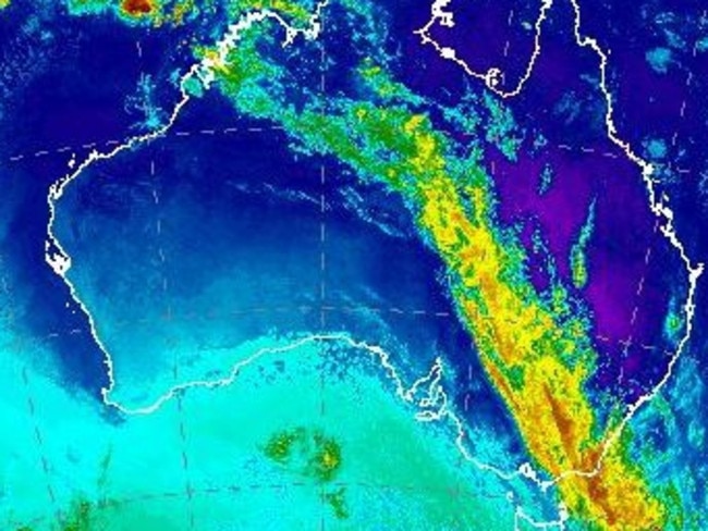
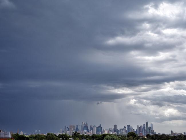
It comes as residents brace for a southerly change with thunderstorms set to bring much needed respite to parts of the country in the grips of a heatwave.
The Bureau of Meteorology warned a severe thunderstorm was on its way for Sydney and its surrounds and urged people to move vehicles away from trees.
#SydneyWeather #Severe #Thunderstorm warning updated: See latest warning at https://t.co/a2916ig7EH and radar images at https://t.co/3RyGPIn5ZV pic.twitter.com/rl6kMIASOY
— Bureau of Meteorology, New South Wales (@BOM_NSW) December 20, 2017
Wild weather already lashed Victoria last night with destructive storms damaging cars and property. It also left 26,000 homes without power this morning.
The storm sent the mercury plunging from 37C to 24C in just 10 minutes as the cool change swept across the state.
While Melbourne can expect a milder 25C today, those living in Sydney were continuing to sweat through a heatwave until this afternoon when 37 km/h winds swept a cool change throughout the state.
Mascot, in Sydney’s south, dropped ten degrees in two minutes after their hottest day in December in 12 years.
“That’s a pretty big difference,” Tristan Meyers, Meterologist Sky News Weather, told news.com.au.
“People feel it pretty quickly”.
Newcastle also saw its hottest day in 12 years, peaking at 40C.
Despite the change, Sky News Weather chief meteorologist Tom Saunders said parts of NSW were now up to day eight of a heatwave.
A heatwave is defined as three or more days of above minimum and maximum temperatures.
It was a hot start to the day in the NSW capital with Sydney’s Observatory Hill hitting 28.7C at 6.30am while Penrith recorded a warm 29C.
Other parts of the state are sweating through above average temperatures today.
Mr Saunders said Tamworth was forecast to hit 40C — which is 8C above average — and this marked the eighth consecutive day with a maximum more than 5C above average.
The good news is the cool change will kick in around midday and hit parts of the coast between 1pm-2pm.
“A trough and front moving east over eastern Australia separates a hot northerly from a cooler southerly,” Mr Saunders said.
“The southerly change is already moving up the NSW south coast and dropped the temperature at Moruya 10C in just over an hour after 7am.”
He said the southerly will hit as a bluster and coastal suburbs should see temperatures drop from the 30s to the low 20s by late this afternoon.
“This follows a very warm night — the city’s minimum stayed above 25C, the warmest night since last summer,” Mr Saunders said.
“Penrith’s maximum of 44.1C on Tuesday and minimum of 25.3C today are the highest for December on record — in 23 years of data.”
#Bourke was the hottest spot in the state today at 45°C, with #Penrith setting a December record at 44.1°. #Tibooburra had the warmest overnight low at a stamina sapping 33°C. Daily review at https://t.co/LGL4QaprRL. #NSWweather #ACTweather pic.twitter.com/NgjoFzPrl8
— Bureau of Meteorology, New South Wales (@BOM_NSW) December 19, 2017
Canberra is expecting a high of 28C — 2C above average and 6C below yesterday’s 34C scorcher.
Penrith will hit 42C, which is 13C above average while Orange will hit 29C.
Scorched Tamworth will hit 40C, which is 10C above average.
The NSW RFS had earlier issued total fire bans for the Greater Sydney Region, The Hunter Region and North Western NSW, with the three areas facing severe fire danger ratings.
The heat has also prompted electricity provider Ausgrid to cancel planned maintenance outages on the Central Coast and Hunter region today.
Mr Saunders said the storms which lashed Victoria yesterday provided welcome relief from the heat across the state.
“Yesterday, the front swept across Victoria and brought severe thunderstorms,” he said.
“Hail was reported from Melbourne’s eastern suburbs, Laverton had a wind gust of 98km/h while the city recorded 21mm of rain in just 20 minutes.
“The trough and front will trigger storms across NSW today, although we do not expect the activity to be as widespread as it was in Victoria yesterday.”
Fire Weather Warning still relevant for the Greater Hunter & North Western fire areas today, with Severe fire danger forecast with hot & windy conditions. Details at https://t.co/g0s2I7ypVi
— Bureau of Meteorology, New South Wales (@BOM_NSW) December 19, 2017
Here’s how the weather is looking for the rest of the country’s capitals in the lead up to Christmas
Today 23C with showers clearing, tomorrow 26C, Friday 28C, Saturday 33C, Christmas Eve 27C, Christmas Day 29C.
Today 32C, tomorrow 32C, Friday 31C with possible light showers, Saturday 31C with possible showers, Christmas Eve 31C, Christmas Day 32C with slight chance of showers.
Today 28C and showers, tomorrow 28C with possible showers, Friday 30C, Saturday 33C, Christmas Eve 34C with possible storms, Christmas Day 27C with possible showers and storms.
Today, top of 25C and showers. Tops of 34C and 35C week with possible storms and showers throughout the week.
Today 25C, tomorrow 25C, Friday 29C, Saturday 29C, Christmas Eve 23C and showers clearing, Christmas Day 24C.
Today 29C, tomorrow 33C, Friday 31C, Saturday 29C, Christmas Eve 31, Christmas Day 34C and sunny.
Today 36C and possible storms, tomorrow 24C with showers, Friday 25C with early showers, Saturday 28C, Christmas Eve 33C with showers and possible storms, Christmas Day 25C and possible showers.
Today 21C with showers, tomorrow 23C, Friday 25C and cloudy, Saturday 23C and showers, Christmas Eve 19C with a shower or two, Christmas Day 20C and cloudy.

Man feared dead in croc-infested waters
There’s been a major update on a man missing more than a week in crocodile-infested waters, as the region is lashed by flooding.
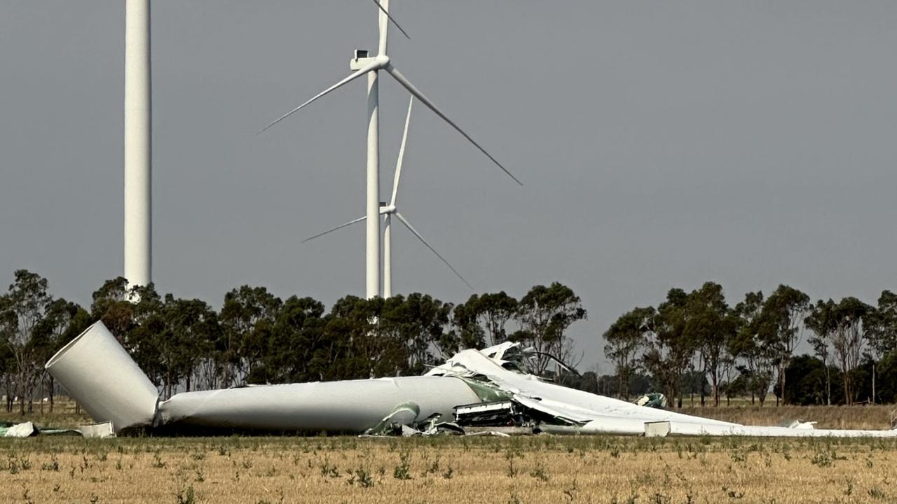
112m turbine collapses on wind farm
A 112m wind turbine has collapsed after severe thunderstorms wreaked havoc in one state, prompting this call.
Albo activates flood payments for victims
Residents in Far North Queensland rocked by surging floods will be able to access emergency disaster relief, Anthony Albanese has confirmed.