
Superstorm unleashes havoc across Australia
THE worst weather in decades has battered even more of the country, with severe warnings in place in five states.
THE worst weather in decades has battered Australia once more, with severe weather warnings in place in South Australia, Victoria, NSW and Tasmania.
One of the biggest storms in 50 years brought tearing winds reaching a terrifying 140km per hour in some locations.
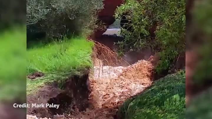
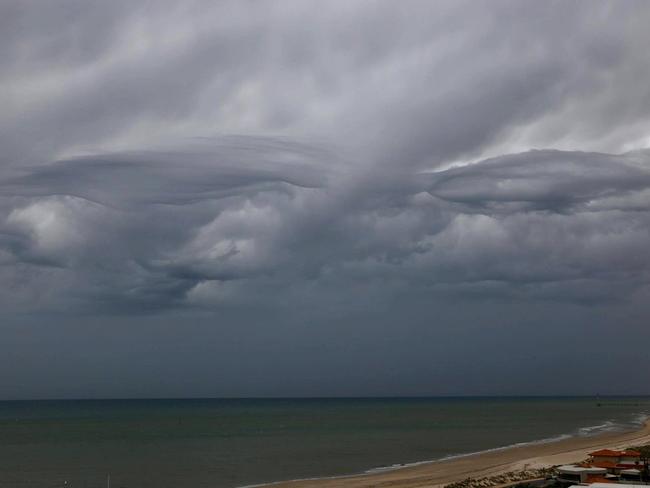
Twin tornadoes were blamed for yesterday’s weather chaos as forecasters warned South Australia had only seen half the rain expected. A flood emergency has been declared for the town of Auburn, north of Adelaide, with a nearby dam bursting.

Thousands are without power in the Adelaide Hills as ferocious winds smash the state, causing storm surges and flooding along the coastline.
SA Power Networks has warned more homes could lose power, with 9000 already customers cut off at Mt Barker and other areas in the Adelaide Hills.
The outages come as electricity has been restored to the Upper Eyre Peninsula.
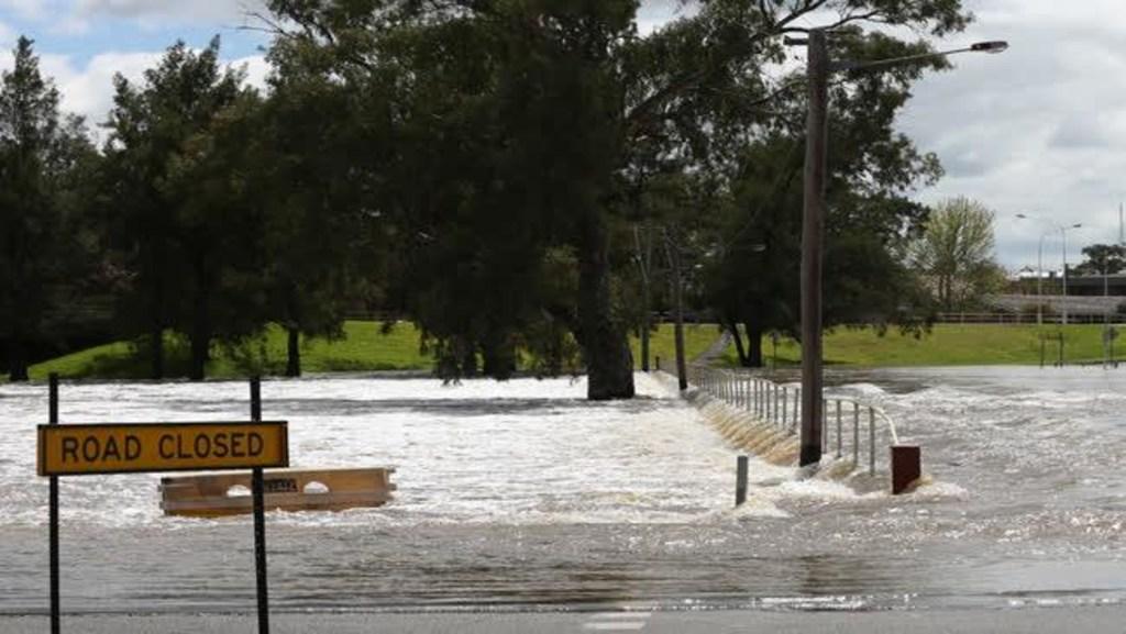
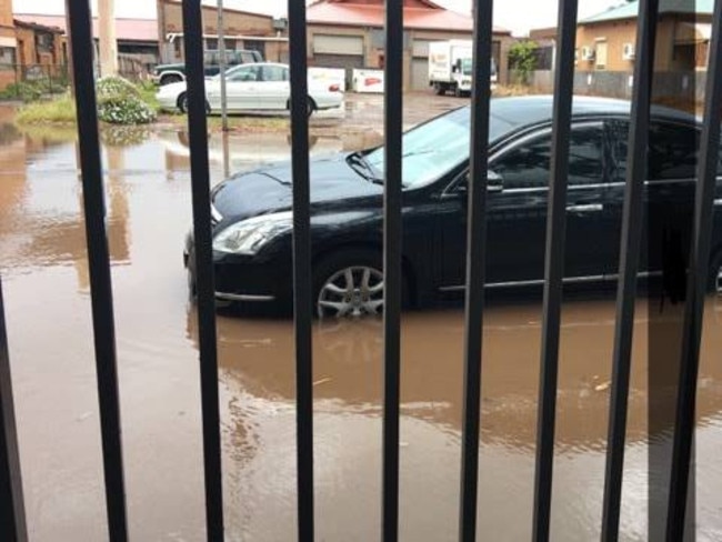
Serious flooding has been experienced at various locations, including Birkenhead, where rising waters has forced the closure of the Birkenhead Bridge.
High tides inundating houses at Port Broughton! Keep safe everyone. #SAStorms #SouthAustralia pic.twitter.com/4GLMBwB64p
— Sonny Coombs (@SonnyCoombs) September 29, 2016
Emergency services have drained a dam in the Barossa Valley after it burst its banks and sent water gushing towards the town of Greenock.
A large hole formed in a wall of the 20-megalitre dam, off Dommenz Rd, allowing water to rush towards Greenock Creek, which flows through the centre of the town.
About 120 CFS and SES volunteers converged on Greenock just after 11am to protect houses and businesses from potential flooding.
Light Group Officer Randal Searle said there were early concerns that homes would be inundated.
The Hutt River at Clare, north of Adelaide, overflowed, with locals reporting about half a metre of water over a section of the Horrocks Highway, which has been closed off.
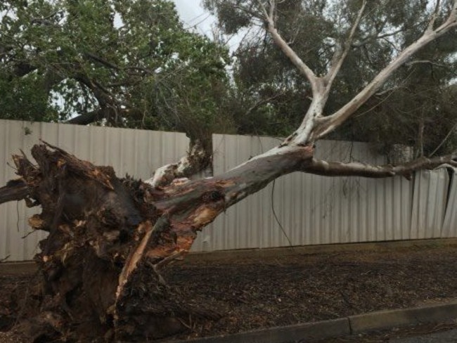
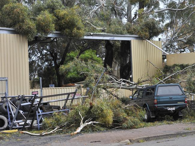
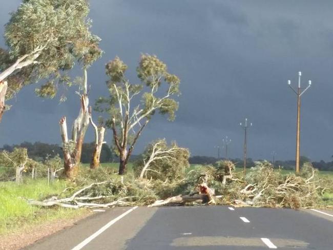
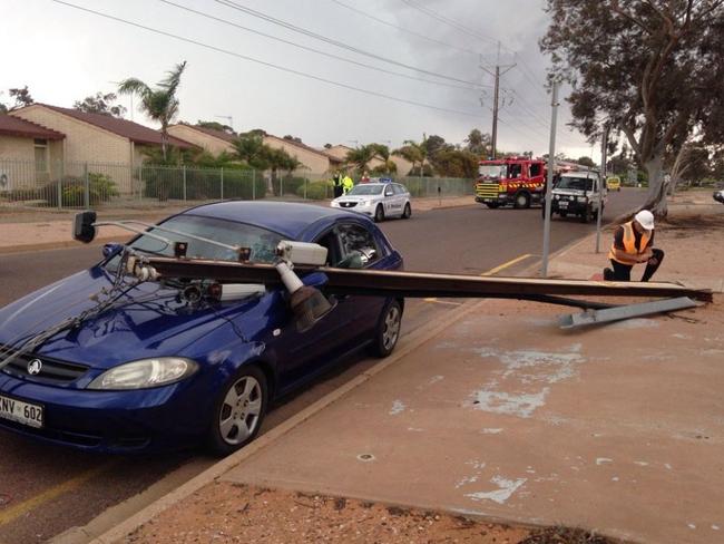
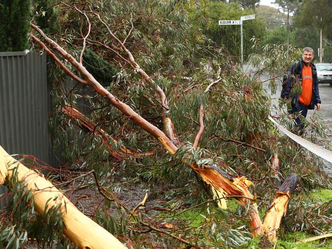
Downed trees and power lines are blocking roads and flood warnings were issued for five states and the ACT, with the worst of the wild weather still on the way.
There have been power outages in Tasmania’s northwest as strong winds and heavy rain lash the state.
The remnants of a deep low pressure system which lashed South Australia yesterday are currently passing over Tasmania.

More than 1500 are without power in the areas of Bagdad, Bridgewater, Brighton and Pontville due to a power pole being down.
There are reports of trees coming down onto roads at St Marys.
Tasmanian Police have urged motorists to drive to the conditions and look out for hazards and debris on the roads.
The “catastrophic” superstorm that left the entire state without power is expected to return with a vengeance, moving east through the south coast of Australia in the next 24 hours, according to the Bureau of Meteorology.
SA was left in total blackout for hours yesterday evening — causing travel chaos, hospital terror and reported looting of homes. Back-up generators at an Adelaide hospital failed during the outage, forcing 17 patients to be transferred to another hospital, many breathing with the help of manual respirators as they were moved.
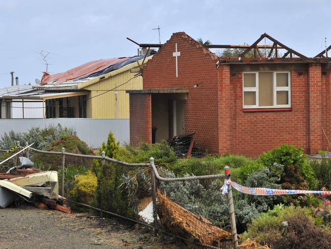
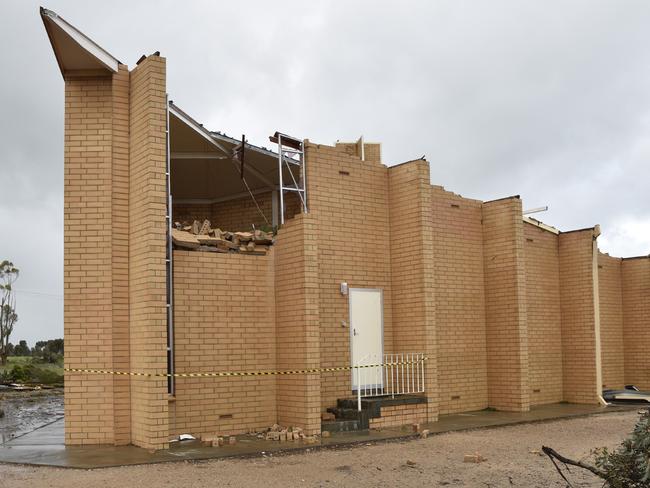
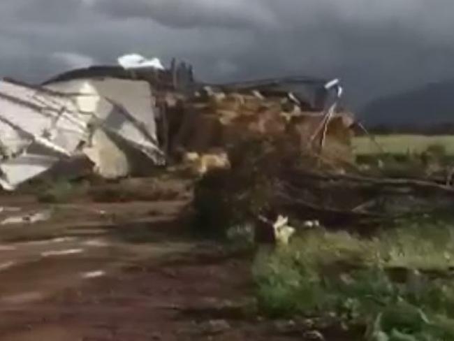
Roofs were torn from homes overnight as gale-force winds, heavy rain and thunderstorms lashed SA and parts of Victoria last night.
The once-in-50-year storm as already hit parts of Victoria and will move into NSW and Tasmania today. It is expected to unleash again tonight, with havoc forecast across the country.
BoM senior meteorologist Craig Burke said a weather event of this size and intensity was unusual, especially when it affected so many locations.
“It’s extremely rare to see a low of this much pressure and intensity,” he said. “It’s fair to say it’s going to get extremely nasty again.”
LOOTING ‘DISGUSTING AND REGRETTABLE’
As the “worst storm in decades” struck the country with force, South Australia was plunged into darkness and triple-0 went down in isolated parts of the state.
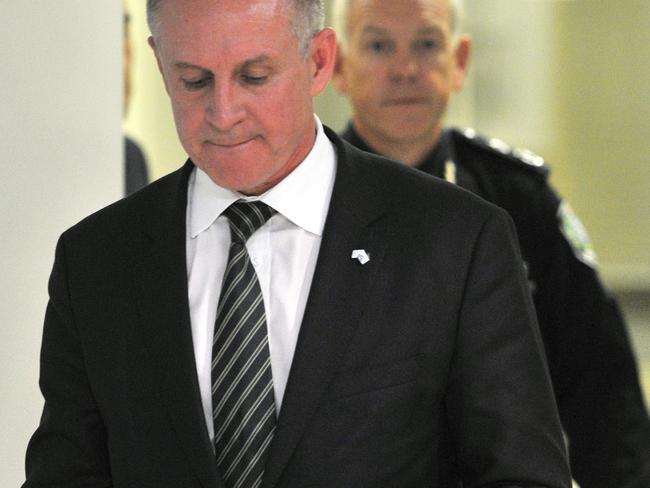
SA Premier Jay Weatherill insisted it was not South Australia’s reliance on renewable energy that led to the blackout, as some have suggested.
“This was not a renewable energy event,” he said, saying it was a “catastrophic weather event” that forced the whole electricity network to shut down.
The Premier said powerful wind gusts and thunderstorms smashed 22 electricity transmission stations near Port Augusta at 3.48pm yesterday, and the toppled towers were followed by a lightning strike, which triggered a safety shutdown.
“This is a catastrophic natural event which has destroyed our infrastructure,” he said in a press conference this afternoon. “These are events the Director of the Bureau of Meteorology has never seen in his whole career.
“There is no infrastructure that can be developed that can protected you against catastrophic events that take out three pieces of infrastructure.”
BoM regional director John Nairn said the state was hit by an extremely vigorous front connected to a very powerful low, with strong wind gusts bringing down trees and towers.
He said Adelaide was now entering a lull but it would be short-lived before the system reintensifies throughout the afternoon and evening.
“We’ve only seen half the rain we’ve expected to see so far,” he said. “We’re expecting quite significant falls tonight.”
Conditions are expected to easy on Friday with better conditions on Saturday but Mr Nairn said there would be further rain on Sunday, Monday and Tuesday, although he didn’t expect this system to be as powerful.
The SES were also bracing for further choas and had already received 900 calls for assistance and 300 since midnight.
Stong winds were expected to bring down more powerlines and trees with warnings for drivers to take care.
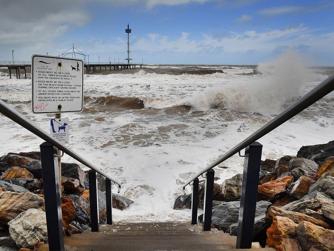
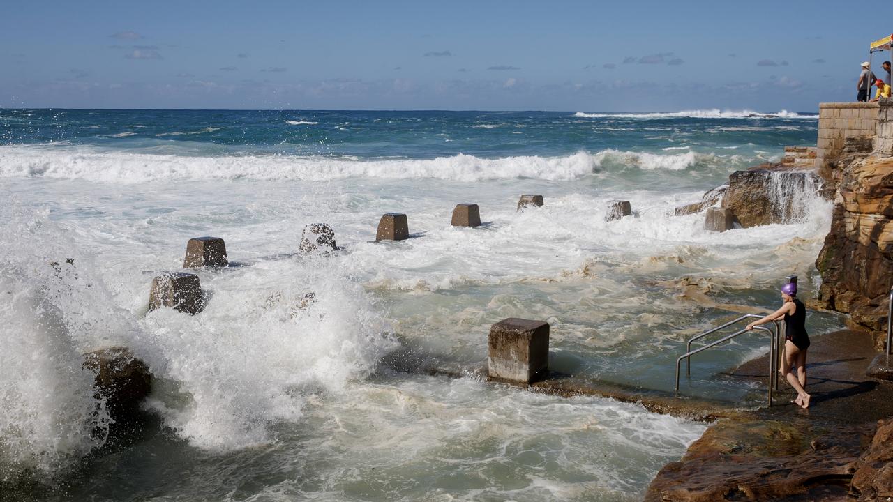
Authorities also warned powerful winds had the potential to whip up mega tides.
Triple Zero services down in some isolated areas. Attend nearest hospital, police or fire station if needed. https://t.co/TpdG4Yo8CE
— SA Police News (@SAPoliceNews) September 28, 2016
People in the red shaded area are supplied by damaged transmission lines – unlikely to have power tomorrow. pic.twitter.com/r5Z35IYtgt
— SA Power Networks (@SAPowerNetworks) September 28, 2016
Mr Weatherill praised the rapid response of the Australian Energy Market Operator, SA Power and emergency services, as well as the “community spirit” among South Australians.
“This is certainly a system that was designed to get the system back up as quickly as possible. In a few hours we were beginning to restore power and now the lion’s share of the system has been restored.”
Ninety per cent of the power was restored in the 38 hours after the blackout, but are 60,000 still without power.
The Premier warned about 40,000 households could be without power for the next two days. Large industrial users are among the last waiting to begin operating again.
“It’s not simply a storm, it’s an unprecedented weather event, the likes of which the bureau has not seen here,” he added. “There are things we have to reflect upon, but our present advice is this was an event which could not have been predicted, it was an extreme event.”
He said there would be a three-pronged inquiry into what went wrong, but said the priority now was to deal with people still suffering, particularly in the north of the state.
On reports of looting, he said: “There’s some isolated incidents the police commission might want to concern themselves with. If that’s happened, it’s disgusting.
“An isolated incident is disgusting and regrettable but I done think it reflects the overwhelming evidence of community spirit.”
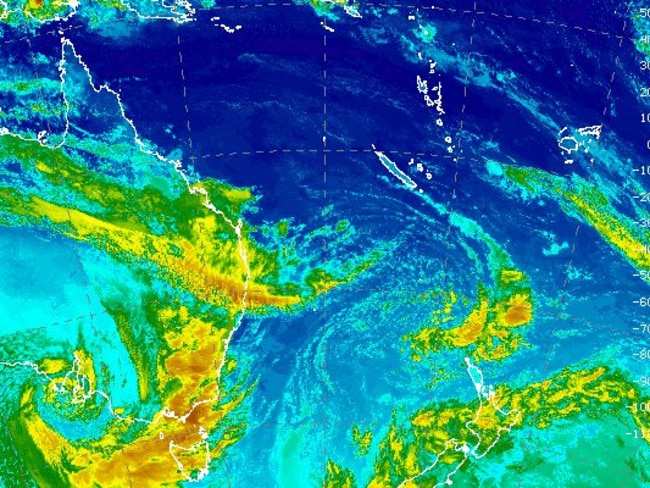
#BoMSat showing intense low impacting SA. Latest warnings including updated Severe Weather Warning at: https://t.co/5wxFrWeCue pic.twitter.com/mZBK5gWOn4
— BOM South Australia (@BOM_SA) September 28, 2016
LIFE AND DEATH
Hospitals came under serious pressure as they switched to back-up power generators to assist people on life support. Handheld battery packs and hand-operated respirators were used as 17 patients had to be moved.
People using life-support devices at home headed to hospitals for extra power, with the wards focusing solely on those in life-threatening situations.
By 7pm (local time) yesterday power had started to be restored to some suburbs, mostly in the metropolitan area’s eastern districts.
Adelaide Hills and northern suburbs were among the worst affected.
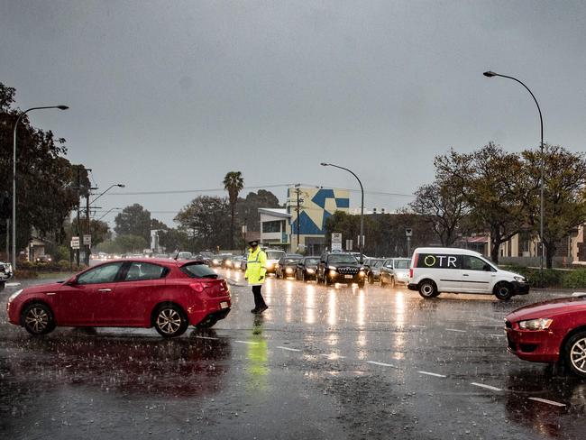
Hail, winds and wild weather made travel impossible with traffic lights out of action and trams and trains cancelled.
The BoM has warned that gale-force winds of up to 120km/h and plenty more rain is expected across the state today.
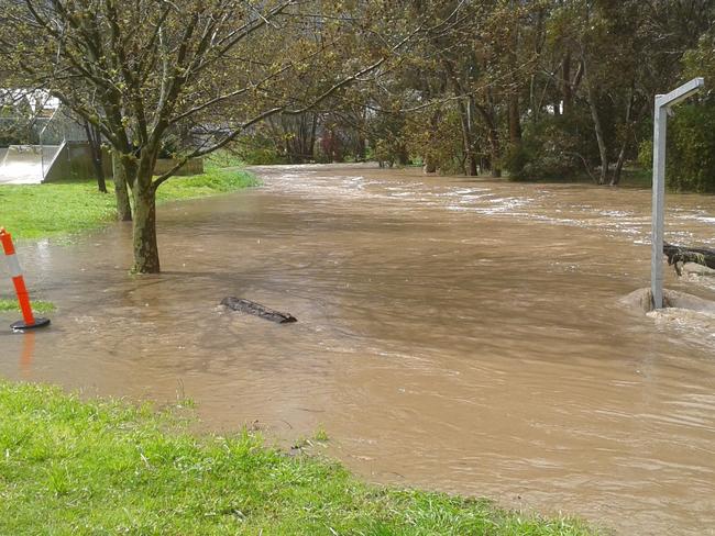
Meanwhile, as strong winds from the storm entered Victoria, trees were blown down and there were reports of some flooding in Mildura last night.
Further heavy rain is predicted in Victoria for the next two days and emergency services will closely monitor north east and north west Victoria still swamped by recent floods.
Victoria’s State Control Centre duty officer Brad Dalgleish said last night: “We are seeing winds around 70km/h around the Grampians.”
Melbourne was expected to get winds about half that speed, but gusts of up to 120km/h are expected to hit the Alpine regions again today.
“We are not expecting that it’s going to be as extreme as what’s happened in South Australia,” he said. But he urged residents to be prepared and be vigilant.
WHAT CAN WE EXPECT NOW
Adelaide can expect cooler temperatures from today with a top of just 15C as a cold front hits.
While conditions are expected to ease slightly, more gusty winds and rain are forecast for later this afternoon.
“The intense low is moving across South Australia bringing more storms,” Mr Burke said.
“It is pretty extreme.”
Strong gale force winds forecast across western and central districts are expected to extend to eastern districts later this morning, with wind gusts of 90-120km/h predicted.
The BoM also warn destructive wind gusts up to 140km/h are possible about the south and west of Eyre Peninsula.
Showers are set to ease tomorrow but the mercury will plummet to just 7C on Saturday.
Further rain is then predicted for Sunday until next Tuesday with a top of between 16-18C across the weekend.
Flood warnings also remain in place for the Onkaparinga River.
Victoria
The state has already experienced gale force winds with parts of the state receiving 50mm of rain.
Melbourne will be largely spared from the showers today and is only set to receive 5-10m. The city will reach a top of 16C today.
The BoM said a severe weather warning has been issued with six flood warnings also in place across the state.
Mr Burke said wind speeds of 145km/hr were recorded at Mt Hotham and 120km/hr at Mt Buller this morning.
Flooded parts of northern Victoria could see more stream rises with heavy rain forecast for today and tomorrow.
A severe weather warning is in place for large parts of the state, with a moderate flood warning also posted for the Loddon River.
“Most of the west and central parts of the state will see rainfall and that will continue into Thursday,” Bureau of Meteorology forecaster Beren Bradshaw said.
“There’s a good chance that we will see renewed stream rises.”
Residents have been warned to watch out for heavy rain leading to flash flooding across the Mallee and Wimmera districts, with rainfall totals of 10mm to 25mm likely.
Further showers are also predicted across the weekend with a top of 18C on Saturday and 23C on Sunday.
Heavy rain and wind easing in NE by late morning. Gusty winds developing in NW. #VicWeather Severe Weather Warning https://t.co/AuqopWpnuI pic.twitter.com/RagTPw79XW
— BOM Victoria (@BOM_Vic) September 28, 2016
New South Wales
Sydney can expect some rain today but should avoid the worst of the wild weather. Central NSW, however, has been warned to prepare for another battering.
The BoM warned between 40mm to 100mm of rain is expected across the state from now until Friday, with the flood-hit town of Forbes expected to be hit hard.
The Lachlan River is also predicted to peak next week near Condobolin and Euabalong, with 10 other flood warnings remaining in place.
It’s expected to clear in Sydney over the weekend, bringing highs of 27C on Sunday and 28C on Monday.
Mr Burke said light to moderate rainfalls were expected across the southwest slopes and central ranges.
Lots of blue on the map over the past 24 hours. Find info on rainfall and river conditions at https://t.co/72XTO7o8rh #NSWFloods #NSWWeather pic.twitter.com/kriGqfX1Mo
— BOM New South Wales (@BOM_NSW) September 28, 2016
Tasmania
The BoM has predicted the island state will cop a drenching of up to 120mm as a “troublesome low” moves in and hits hard today.
Snow is also forecast in areas above 1000m while Hobart is bracing for heavy rain which is also set to fall across northern parts of the state.
Further rain and showers are predicted across the weekend and up until Tuesday with lows of 8C and highs of 17-19C.
Rain & wind NW #Tas now, N & NE this morn, E & SE Arvo/Even. high gust so far (kmh) Flind Is 91, Smithton 80 kmh. https://t.co/NHL3HY0zFO pic.twitter.com/mydK1G7y7A
— BOM Tasmania (@BOM_Tas) September 28, 2016
Queensland, Western Australia and the Northern Territory have been spared from the monster low, but all states can expect some cold and rainy conditions in the days ahead.
Queensland
Brisbane will hit a top of 23C today with some light showers, however the BoM have issued
flood warnings for 11 rivers including the Dawson, Balone and Moonie.
The city will remain fine and sunny for the weekend with tops of 27-28C before further showers are predicted for Monday and Tuesday.
Western Australia
A cold front moved across Western Australia on Tuesday bringing showers to many areas including Perth.
While the capital is forecast for fine and sunny conditions today, showers and tops of between 18-20C are expected for the rest of the week.
Northern Territory
The Top End isn’t immune to the wild weather, with thunderstorms hitting Darwin from now until next Tuesday.
Temperatures are likely to hover at about 34C, but no weather warnings are in place.
SUPERSTORM FURY: HOW IT UNFOLDED
South Australia was hit first by the storm with roofs blown off homes, and power lines and trees came down across the state.
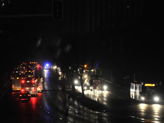
The state capital’s roads were totally gridlocked as police patrols were dispatched to guide traffic at intersections and residents were warned to avoid travel wherever possible.
A few buses were made available for some commuters. Hospitals and some other buildings were operating as normal on back-up power.
The blackout came as torrential rain and winds of 87km/h lashed the state, hitting Adelaide at 12pm yesterday.
Facebook user Julie Minge shared extraordinary footage of golf ball-sized lumps of ice battering her neighbourhood in Cleve, SA.
The BoM had warned supercell thunderstorms across the central and mid-north districts could produce destructive 140km/h gusts, heavy rainfall, flash flooding and more massive hailstones.

BLACKOUT CHAOS
SA Ambulance asked South Australians to only call triple-0 in a genuine life threatening emergency and SA Power advised people to conserve their mobile device batteries and prepare for extended outages.
The State Emergency Service earlier advised people to keep their phones charged up in case of power cuts.
Adelaide Airport said flights had been disrupted by the storm and told passengers to check with their airline.
The BoM issued a severe thunderstorm warning for an area stretching from Victor Harbor, south of Adelaide, to Marree.
Oops, lights gone out in #Adelaide Airport. Hope my flight can still leave in 90 mins. #AdelaideStorm #Qantas pic.twitter.com/Ivs0aqEHzN
— Liam Shorte (@SMSFCoach) September 28, 2016
Major centres to feel the impact of the storms included Whyalla, Port Augusta, Hawker, Port Pirie, Clare, Roxby Downs and Leigh Creek.
The extreme weather dumped 90mm of rain in some areas, including the Adelaide Hills, where a flood warning was in place.
Similar falls were possible in the mid-north with the cyclonic conditions expected to whip up large swells along the state’s coastal waters, producing 10-metre waves.
By late afternoon yesterday the State Emergency Service had responded to more than 330 calls for help, most because of fallen trees or rising water. It earlier distributed more than 43,000 sandbags to local residents concerned about possible flooding after severe weather just two weeks ago flooded 80 homes across Adelaide and the Mt Lofty Ranges.
This will all be sorted out before #TheBacheloretteAU right, @JayWeatherill?? #AdelaideStorm
— Tom Richardson (@TomRichardson) September 28, 2016
There is gonna be a mad baby boom in Adelaide 9 months from now. #AdelaideStorm
— Kristinâ„Winterfjord (@LornaViking) September 28, 2016
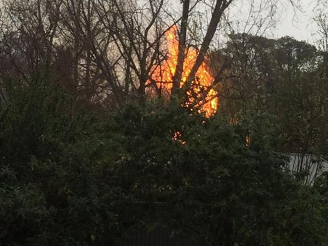
SA fire services warned the public to ensure all heating, cooking and other appliances in use when power went out were switched off.
John Nairn told AAP the weather had the potential to cause widespread destruction. “This depth of low, this close to the coast, is very damaging,” he said. “It’s a very significant event for South Australia. It’s very rare.”
- with Elizabeth Henson, in Greenock, and Colin James, The Advertiser and David Killick and Alex Luttrell of the Mercury.


Millions facing long weekend washout
Long weekend plans could be under threat across swathes of the country as millions brace for heavy rain and thunderstorms.
Major city rocked by earthquake
People have rushed onto the streets after the city was hit by a 6.2 magnitude earthquake on Wednesday.
Easter weekend drownings deadliest ever
A fateful combination of weather conditions has created the deadliest Easter long weekend in Australia’s recorded history.