
Snow flurries and bushfires as contrasting weather bears down at the start of summer
A “dangerous weather recipe” is unfolding with parts of NSW likely to see their coldest December day for 60 years as bushfires rage nearby.


As bushfires rage across vast stretches of New South Wales, southern areas of the state could sink to their lowest December temperatures for almost 60 years.
And while that spell of wintry weather occurs, in three capitals this week the highs might not get below 30C.
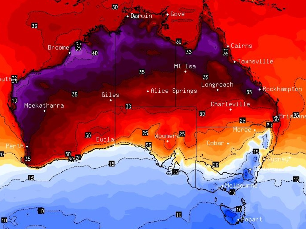
Currently parts of Australia are sweltering while in other parts it’s summertime snow and highs below freezing. It’s a weird start to the warmest season.
“The third cold front in as many days is bringing a burst of polar air and some showers across the south east,” said Sky News Weather channel Meteorologist Alison Osborne.
“We’ll see a drop in temperatures and what that means is that if it is showering it will be cold enough to snow.
“If Wagga Wagga hits 17C today it will be its coldest December day in 59 years.”
A feezing start to #summer in the south with heavy #snow in the alps overnight. Snow will continue today with a max of just 1 at Perisher. Weather warming up from tomorrow. Latest #alpine forecast: https://t.co/bwilfRUg7C pic.twitter.com/cdaGLGug7C
— Bureau of Meteorology, New South Wales (@BOM_NSW) December 1, 2019
You may have woken up this morning thinking it's mild - but dangerous fire conditions are likely this afternoon. Strong winds are forecast. These winds are likely to push a number of fires towards communities today. At 9am - 126 fires, nearly 50 not contained. #nswrfs #nswfires pic.twitter.com/vAMappuY4E
— NSW RFS (@NSWRFS) December 1, 2019
It was a wet Sunday in #Victoria thanks to yesterday's cold front! ðŸŒ§ï¸ 24-hour totals generally 5-15mm, but 25-35mm over the eastern ranges, with isolated falls of 40mm+. Highest so far: 50.4mm at Black Range Trout Farm (near Whitfield). Find obs here: https://t.co/Mdg6GJigMQ pic.twitter.com/5v0x8ql3jh
— Bureau of Meteorology, Victoria (@BOM_Vic) December 1, 2019
COLD, SNOW IN SOUTH
The cold fronts are coming in from the Great Australian Bight. Already they’ve led to a wet weekend in Victoria with 5 to 15mm of rain across much of the state but more than 50mm in some places.
Alpine areas are likely to continue to be cold enough for snow for the next couple of days.
The mercury will dip below average in Melbourne reaching just 15C today with possible showers.
Temperatures will steadily rise to 19C tomorrow and 23C on Thursday before sinking into the teens again heading into the weekend.
RELATED: Fire bears down on the Blue Mountains’ iconic Three Sisters
Higher elevations of Tasmania could experience flurries. Mt Wellington could see snowfall in summer this week with lows of -4C.
Hobart won’t even get above 20C this week, with the highs hovering around the mid to late teens. There is a chance of showers just about every day.
The Southern Annular Mode climate driver as been pushing colder air into south east Australia for much of spring and now summer too.
Also chillier than average for December in Adelaide. A high of 18C today and then stuck around the 23C mark for days on end.
BUSHFIRES, SCORCHING HIGHS FURTHER NORTH
Heading across the Murray and the weather really is all over the shop. Snow will likely fall on the Alps as the residents of the Riverina wrap up warm.
Yet out of control bushfires are burning 150 kms east at Currowan.
Canberra might only reach 14C today but temperatures will rise into the twenties hitting 27C on Thursday.
“That frontal system will deliver very strong winds across NSW and Queensland, notably across large areas of fires. These are dangerous conditions,” said Ms Osborne.
The Currowan fire has almost doubled in size after being whipped up by westerly winds. Fire and gusty winds was a “dangerous recipe,” said Ms Osborne.
Emergency warnings are in place in NSW as around 125 fires rage — with one burning close to the Blue Mountains’ iconic Three Sisters.
Windy in Sydney reaching 23C today and then as high as 32C on Thursday. Expect more of the same when it comes to smoke haze given the number of fires burning relatively close to the city.
A severe weather warning has been issued for Hunter, Illawarra, Northern Tablelands, parts of the Mid North Coast, Central Tablelands and Southern Tablelands for damaging winds this afternoon.
A Severe Weather Warning has been issued for Hunter, Illawarra, Nthn Tablelands, parts Mid North Coast, Central Tablelands and Sthn Tablelands for damaging winds. Safety in stormy & windy conditions go to #NSWSES https://t.co/YaSG2jLmYq Full warning: https://t.co/FRLXdGrcfj pic.twitter.com/VHJ5oiPCGS
— Bureau of Meteorology, New South Wales (@BOM_NSW) December 1, 2019
Those cold fronts might suck in cold air further south but as you go north the westerlies will pull desert air towards the coast upping the mercury.
A high of 34C on Brisbane today to kick off a week of warm 30C plus weather. It could hit 36C on a sunny Wednesday.
Darwin is also looking at a week topping at 35C but with possible storms.
A scorching week in Perth. Today’s 35C is just a taste of what’s to come.
It will reach 39C on Tuesday in the Western Australian capital and 37C later in the week.
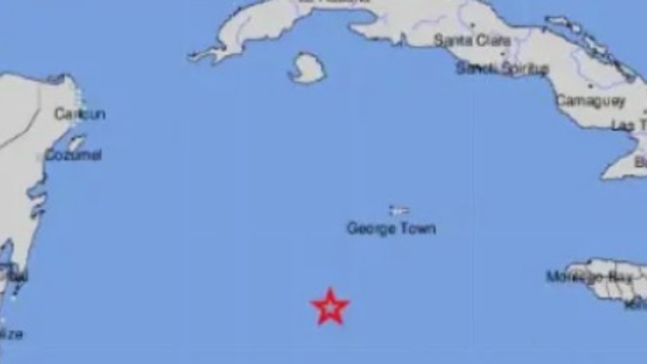
Tsunami warnings after massive quake
A magnitude 7.6 earthquake in the middle of the Caribbean Sea triggered a wave of tsunami warnings around the region.
Cyclone threat for Aussie tourist town
Residents have been warned to stay inside and secure their belongings as a tropical cyclone threatens to develop and smash the coast in the next 24-48 hours.
Top 10 Aussie beaches revealed
Move over Bronte and Byron Bay, Australia has a new best beach according to the national tourism council