
Tropical Cyclone Trevor expected to hit Northern Territory, while Veronica approaches WA
Mass evacuations are taking place as two enormous cyclones converge on Australia, with a state of emergency now declared.
Mass evacuations are taking place across large areas of the Northern Territory as authorities prepare for the arrival of Cyclone Trevor.
The Territory Government has declared a state of emergency in its Gulf region as the system nears the coast. It’s due to make landfall as a dangerous category 4 storm some time on Saturday.
NT Police have said many shelters in remote areas are strong enough to withstand a category 3 storm. But should Trevor increase to a cat 4 the shelters may not stand.
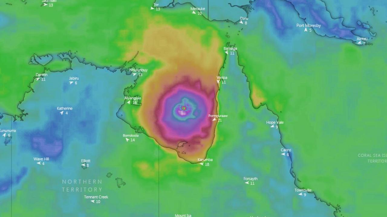
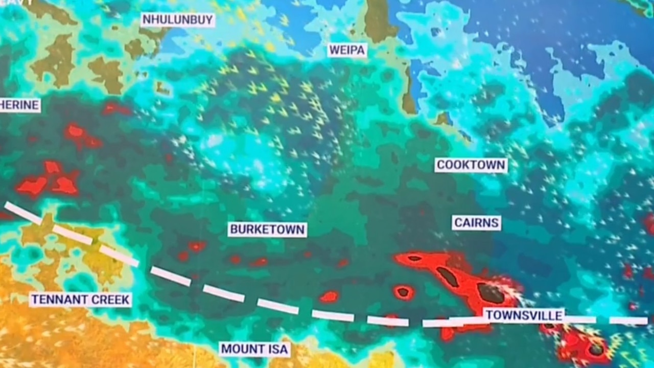
Currently just west of Cape York, Trevor is only at category 1. But the wide expanse of warm waters in the Gulf of Carpentaria will power it back up.
Category 4 systems are classed as “severe’ by the Bureau of Meteorology and can see winds of up to 279km/h and lead to structural damage with looser homes, such as caravans, blown away. Large scale power failures and airborne debris are likely.
The Government is evacuating all 1600 residents of Groote Eylandt and hundreds of people from Numbulwar on the Arnhem Land coast.
It is forecast to have an eye of the storm around 30km wide, which is the same size as the entire Cyclone Marcus that hit Darwin a year ago.
But it is not alone. Cyclone Veronica, which is set to approach Western Australia’s Pilbara coast this weekend, has intensified from a Category 1 to 4 overnight.
It is expected to intensify even more overnight and could reach a Category 5 by Friday.
The Bureau of Meteorology warned the cyclone would have a severe impact.
âš ï¸ Severe Tropical Cyclone Veronica continues to intensify! This loop shows it develop from a Category 1 to Category 4 over the last 24hrs! 🌀 It will approach the Pilbara coast during the weekend. Keep up to date with the latest at https://t.co/L0mHbEKftg #CycloneVeronica pic.twitter.com/sjqPImFnQz
— Bureau of Meteorology, Western Australia (@BOM_WA) March 20, 2019
Residents along the Pilbara coast are being warned they could face winds gusts in excess of 165km/h as Cyclone Veronica reaches the coast.
Police, Emergency Services personnel and local authorities have warned locals not to venture outside if you find yourself in the eye of the cyclone, saying “destructive winds from a different direction could resume at any time”.
Weather bureau meteorologist Lauren Pattie said Cyclone Trevor was expected to move towards the Northern Territory on Saturday and Sunday.
But it could stall and move back towards Queensland next week. “It’s a little to early to say how strong that system will be when it comes, but we are likely to see an increase in shower and storm activity for the southern part of Queensland,” Ms Pattie said.
She said any rains could be welcome news to farmers struggling with drought. “At this stage we aren’t expecting any particularly significant rainfall totals, but that area is quite dry at the moment, I’m sure any rainfall will be welcome,” Ms Pattie said.
Many roads and schools are closed across the cape and residents are reminded not to risk driving on flooded roads, and to be careful of wildlife.
eastern Gulf of Carpentaria. #CycloneTrevor https://t.co/AWJKLhynnl pic.twitter.com/f1lOfOb7kP
— Bureau of Meteorology, Northern Territory (@BOM_NT) March 20, 2019
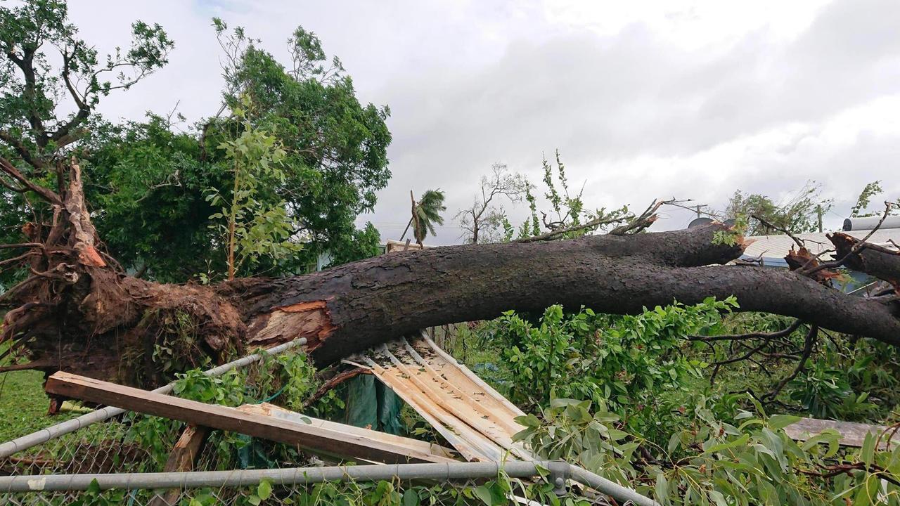
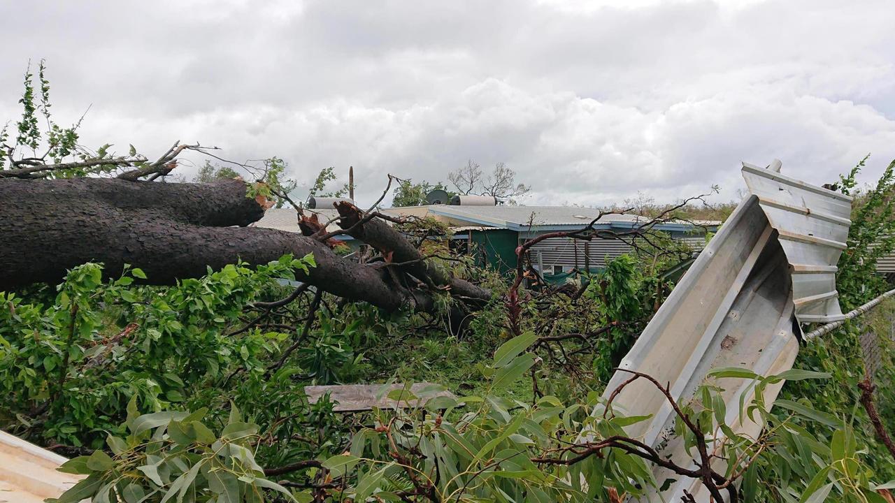
TRAIL OF DESTRUCTION
Trevor has uprooted trees, closed schools and roads and caused power outages with severe gusts and heavy rain since it made landfall in Queensland’s north.
The Aurukun community is likely to be cleaning up on Thursday, after taking cover on Wednesday while Trevor passed on its way to the Gulf of Carpentaria.
Trevor began ripping through the region late on Tuesday as a category three storm, dumping 300mm of rain and recording wind gusts of more than 133km/h. It left Queensland as a category one, but looks likely to power up again to a category 4 over the gulf over the weekend.
GALES AND DESTRUCTIVE WINDS
Gales are expected to extend across western parts of Cape York Peninsula on Thursday morning and impact areas between Cape York and Pormpuraaw, including Aurukun and Weipa as the cyclone moves offshore and re intensifies.
Destructive winds, with gusts in excess of 130km/h may develop between Weipa and Aurukun on Thursday. Gales may further extend south to Kowanyama on Western Cape York Peninsula coast on Thursday night as the cyclone intensifies, and move to Burketown and Mornington Island later on Friday.
As the cyclone intensifies, a storm tide is expected between Mapoon and Aurukun on Thursday morning. Large waves may produce minor flooding along the foreshore.
A separate Severe Weather Warning is current for areas between Lockhart River and Cooktown on the eastern parts of the Cape York Peninsula District.
A Flood Warning is current for the Daintree and Mossman Rivers as well as a broader Flood Watch for catchments north of Innisfail to Kowanyama.
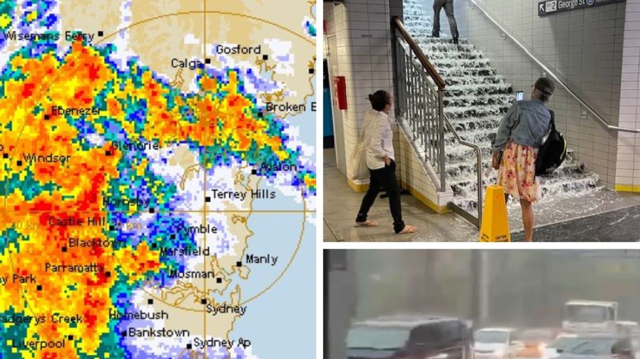
State braces for more severe storms
More than 20 people have been rescued after becoming trapped in floodwaters while thousands are without power as storms threaten to smash NSW for a second day in a row.
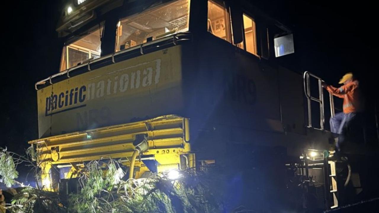
Train crash causes diesel spill in beloved region
Emergency services are mopping up a diesel spill in a tourist region after a train crashed into a tree.
Worst news possible for flood-ravaged towns
Already flood-ravaged areas of Far North Queensland are bracing for the next deluge, with warnings in place for flash flooding and torrential rain.