
Seven of Australia’s capital cities set to surpass 30C this week as heat spike hits
It’s going to be an absolute scorcher of a week, above 30C just about everywhere, and that comes a day after one capital recorded its second hottest day ever.


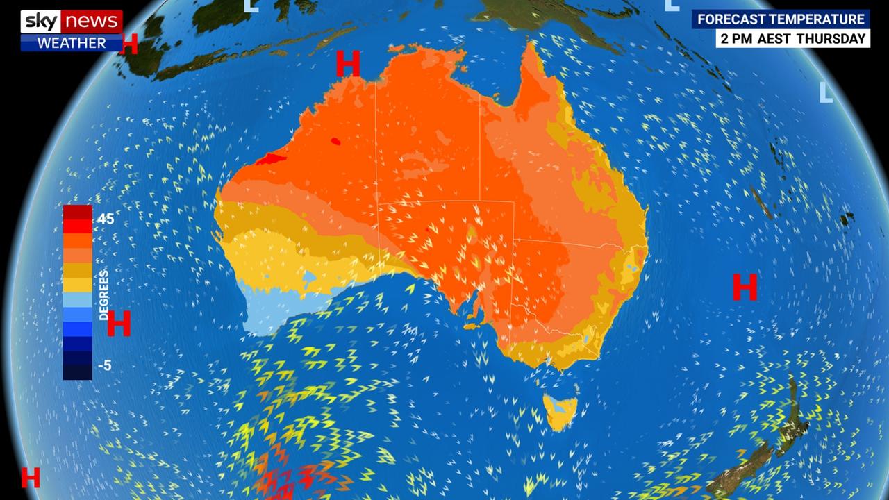
A massive heat spike is set to spread across Australia this week with seven out of the country’s eight capitals surpassing, and in some instances far exceeding, the 30C mark.
That comes in a week when Darwin recorded its second hottest day since records began. On Monday, the Northern Territory city topped out at 38.2C — it hasn’t been that warm for 37 years.
This week, Sydney will reach 33C, or 37C in the west; Melbourne will also get to 33C while Adelaide will roast through a 36C day. Parts of Victoria could see their hottest October day for four years.
Only Hobart will escape the searing temperatures. But even there it will be 10C above average at 27C.
“Thursday will be the hottest day since March for capitals including Adelaide, Canberra and Melbourne,” said Sky News Weather channel Meteorologist Alison Osborne.
🌡ï¸HOT today in #Darwin! Today was officially the second hottest day on record, reaching 38.2C at 12.30pm. The all time record was 38.9C in 1982. Check out temp drop and humidity jump when the #seabreeze 💨 came in at lunchtime https://t.co/UblGYSiWQq pic.twitter.com/ISODDdzlFF
— Bureau of Meteorology, Northern Territory (@BOM_NT) October 21, 2019
Despite the boiling conditions, it won’t be a heatwave. A heatwave is officially defined by the Bureau of Meteorology as three or more days of unusually high maximum and minimum temperatures in any given area.
These are then divided into bands depending on seriousness, with “extreme” heatwaves the most dangerous as they can prove debilitating to even the fit and healthy.
On Friday, Sydney will be 11C above average — that’s certainly “unusual”. But the rise in the mercury is also set to be brief. By Sunday, temperatures will have plummeted to a maximum of just 21C which is actually below average.
So, it’s probably more accurate to think of it as a heat “spike” rather than a heatwave.
High pressure is sat over much of the continent right now which means settled conditions and winds blowing desert air to the south. That’s warning things up nicely.
A cold front is then set to approach through the Great Australian Bight in the middle of the week. Cold fronts often have the effect of pushing temperatures even higher for a brief period before they then fall as the front passes.
WHEN WILL THE HEAT HIT?
Adelaide looks set to be first in the firing line. Maximums there will peak at 29C today, then 31C on Wednesday and 36C on Thursday just before the front enters town. And when it does come through it could be with a jolt, accompanied by a thunderstorm.
“There will be relief with a cool change bringing showers to the south east on Friday and into Saturday,” said Ms Osborne.
The mercury will then sink dramatically with the peak on Friday some 17C cooler at just 19C with possible rain.
Inland, Thursday could see 41C in Roxby Downs.
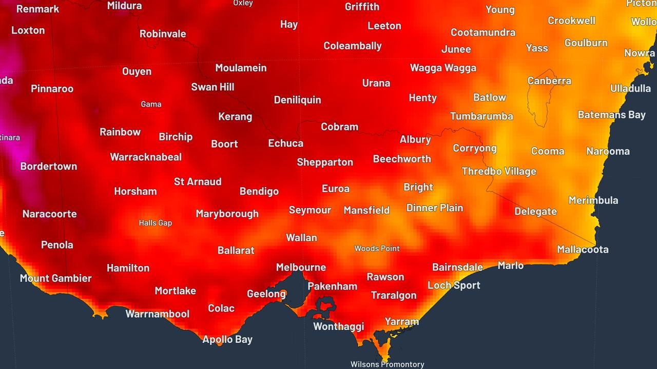
In Melbourne, it will begin to warm up on Wednesday hitting 28C and then 33C on Thursday. Windy, wet and a possible storm overnight with Friday peaking at 25C and then Saturday on just 16C, well below the average for October.
Mildura, in Victoria’s north west, is looking at 38C on Thursday which would be the hottest October day for four years.
Sunny, warm and dry this week in Vic until a cool change Friday morning. Thursday's temps are into the 30s across most of the state, nearing 40 in the far NW. It's on track to be the warmest October day in 4 years for many locations. https://t.co/zdLTMNeQmT #VicWeather pic.twitter.com/Tofgw6NBtM
— Bureau of Meteorology, Victoria (@BOM_Vic) October 21, 2019
Temperatures rising this week, reaching the low 40's in the north and west on Thursday, ahead of a colder change later Thursday or early Friday. Temps on Friday back to the mid teens in the south, grading to the mid 20's over most of the north of SA. #SAweather.
— Bureau of Meteorology, South Australia (@BOM_SA) October 21, 2019
Canberra’s hottest day will be Thursday on 31C but with a chilly low of 7C. It will be warm on the run up to Thursday with a high of 28C today. The heat should remain on Friday before the cool change reduces the maximums to just 17C on Saturday.
Further from the passage of the cold front, Sydney’s hottest day will be later in the week. Today will see a high of 24C, then 26C on Wednesday, 27C on Thursday and a high of 33C on Friday with Penrith on 37C. The western Sydney suburb will likely hit 30C for the next four days.
On Saturday, the temperatures will drop to 27C in the city, 28C in the west, and then a mild 21C on a sunny Sunday. No rain forecast and overnight lows will be in the mid to late teens.
Expect highs in the mid to late twenties in a sunny Brisbane this week. Then on Saturday it should hit 33C, a full 7C above average. Sunday will see a drop to 28C and then 16C on Monday.
Toasty in the Top End with Darwin on around 35C all this week but with a possible storm on Friday and some showers that should pull the highs down slightly.
Darwin is one of the few places that could actually see a heatwave this week with a mix of severe and low intensity heatwaves hitting the region. Conditions should ease by the end of the week.
Perth will see its heat peak on the weekend with 32C on Saturday. That’s likely to mean a second burst of hot air will then roll over the south east early next week as weather generally travels west to east.
Temperatures are likely to hit 26C today in the Western Australian capital, then a cooler 23C on Wednesday with a possible shower. Warming up from Friday which will see 25C.
This leaves the outlier as Tasmania. A mild high of 21C today and then 22C tomorrow. The hottest day will be Thursday with 27C then 25C on Friday when a few splatters of rain may be seen. On Saturday, 16C will be the maximum for Hobart.
‘Don’t return’: Deadly floods to worsen
Residents have been urged not to return home as deadly floods continue to smash one state, as towns are cut off and some areas record more than a metre of rain.
‘Hoodwinked’: China is conning the world
An Australian economist says China is conning the world on an important global issue.
State smashed by ‘hours of lightning’
Thousands have gone without power as wild storms battered one state, with “hours of lightning” recorded in a major city and its surrounds.