
Hawkesbury, Nepean and Georges rivers rise: Residents told to evacuate in Sydney
Fresh evacuation warnings have hit Sydney as the SES urges residents to use caution during heavy rainfall affecting many suburbs tonight.
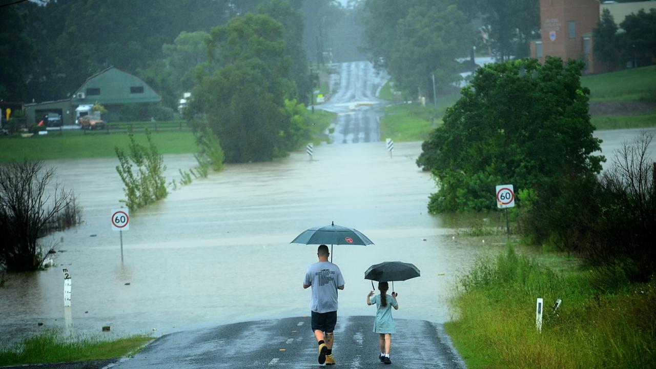
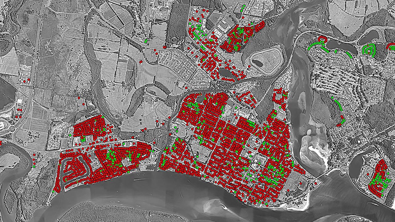
Hundreds of thousands of residents in a number of suburbs in Sydney’s north west have been urged to evacuate as a deadly weather system that caused devastation in Queensland and northern NSW sweeps down Australia’s coast.
The dangerous weather began its journey south on Tuesday, with a low-pressure system developing off the northern coast of the state expected to strengthen into a major east coast low in the coming hours, prompting authorities to issue severe weather warnings from Newcastle to below Bega.
Overnight, the Hawkesbury, Nepean and Georges rivers continued rising at a rapid rate sparking a string of urgent evacuation orders across Sydney’s south-west and west.
Menangle, North Richmond, Penrith and Windsor are all expected to be affected and residents urged to leave.
NSW SES urged residents in parts of Camden in the south west of the city to evacuate “now” while 11pm and 3am evacuation warnings were also in place for people in parts of Moorebank, Chipping Norton, Warwick Farm, Lansvale, Milperra, Georges Hall, Picton and more.
The Redbank Dam in North Richmond is also likely to fail and cause flooding to properties below. NSW SES is directing people from 14 streets within a “high danger” area to evacuate.
In the latest update, the Bureau of Meteorology said “dangerous, heavy and persistent rain” is falling over Sydney and increasing the threat of major flooding.
Major Flooding is occurring in southwest Sydney exceeding March 2021 levels with Major Flood warnings in place. It's raining, with some areas hit harder than others and more rain on its way. Keep a serious eye on the warnings and forecasts: https://t.co/2qM1QRn3xE@NSWSESpic.twitter.com/37j66m7iHA
— Bureau of Meteorology, New South Wales (@BOM_NSW) March 2, 2022
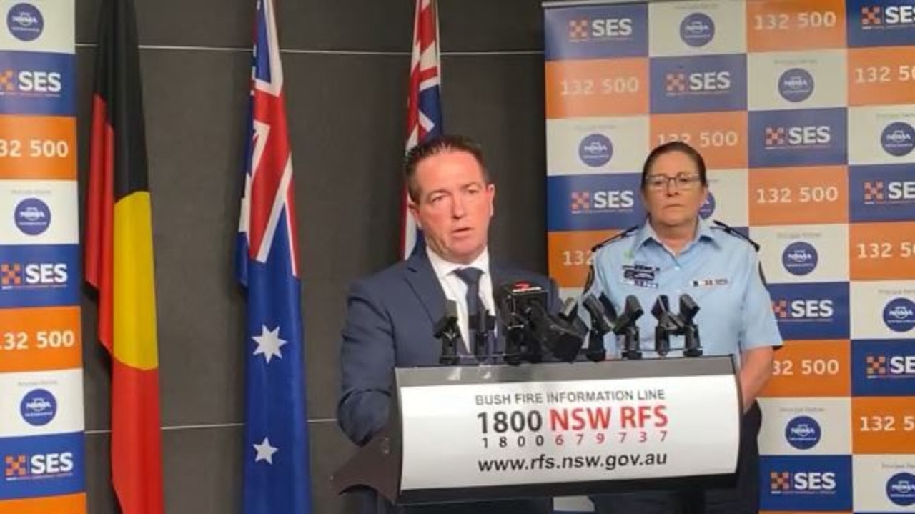
“This is our worst fear. We are seeing the situation get worse. And it will get worse before it gets better. If you were affected by floods in March of 2021, then you are asked to leave your home now,” Deputy Premier Paul Toole warned in a briefing Wednesday afternoon.
“This is going to be a tough night for residents in that area. This is going to be a tough night for people here in NSW.
“If you’ve received that text message, if you’re getting this information, if you were affected by floods in 2021, get out now.”
SES commissioner Carlene York said the rainfall was unprecedented.
“I also must caution you that this is an intense rainfall and we have seen record levels that we haven’t seen in the recorded history,” she said.
“So even though your street may not be mentioned in some of these alerts, just be aware that the waters may rise in other areas and be alert and be prepared.”
Ms York said “quite a few hundred thousand people” would be affected by the alerts sent out tonight, including nine locations subject to evacuation warnings.
For emergency help in floods and storms, call the NSW State Emergency Service on 132 500. In life threatening situations call triple-0 (000) immediately.
Evacuate the following area by 11pm
Parts of Ebenezer:
- All properties along Hendrens Road and 114-136 and 113-161 Ebenezers Wharf Road.
- All properties on Coromandel Road bordering the Hawkesbury River.
Evacuation route here.
North of Bligh Park:
- Properties between Bligh Park and South Windsor along Berger Road and Fairey Road between the Sewerage Treatment plant at the southern end and Penruddock Street at the northern end. Find the evacuation route here.
Parts of Sackville:
- All properties in the following streets in Sackville:562 to 624B and 555 to 715 Tizzana Road. Evacuation route here.
Parts of Cattai:
- 177 O’Briens Road
- 161 O’Briens Road
- 87 to 97 Cheesmans Road
- 70 Cheesmans Road
- All residents in Riverside Caravan Park in Cattai. Evacuation route here.
Parts of Agnes Banks:
- All properties in low lying parts of Agnes Banks along Springwood Road from the Yarramundi Bridge to Price Lane, and including Price Lane. Evacuation route here.
Parts of Leets Vale:
- Properties along River Road from Douglas Creek in the part of Leets Vale on the southern side of the Hawkesbury River.
Low lying part of Freemans Reach:
- Properties in the lower part of Freemans Reach along Freemans Reach Road from Wilberforce Road to Hibberts Lane, along Hibberts Lane Freemans Reach Road to the first bend northwards, along the lower part of Argyle Reach Road
- Properties in the southern part of Wilberforce along Wilberforce Road from Windsor Bridge to Buttsworth Creek.
Evacuation route here.
Evacuate the following area by 3am
Georges Hall
Parts of Chipping Norton:
- Southern side of Newbridge Road, between Davey Robinson Drive and Miperra Bridge
- Northern side of Newbridge Road between Rickard Road and Riverside Road.
- Eastern side of Henry Lawson Drive, between Milperra Road and Auld Avenue.
- Epsom Road between Westbury Street and Governor Macquarie Drive.
- Riverside Road between Newbridge Road and Alfred Road
Parts of Lansvale:
- Knight Street between Day Street and Hollywood Drive
- Lower Day Street
- Erna Avenue
- Lucy Avenue
- Mena Avenue
- Willis Street
- Hollywood Drive Between Knight Street and Willis Street
Parts of Milperra:
- Auld Avenue
- Deepwater Park
- Eastern side of Henry Lawson Drive between Milperra Road and Keys Parade, Webster Street, Maxwell Avenue.
Parts of Warwick Farm:
- The Warwick Farm Racecourse
Parts of Moorebank:
- Western side of Epsom Road, Between Westbury Street and Childs Road
Full list of locations ordered to evacuate
Camden:
- Sheathers Lane
- Kirkham Lane
- Menangle Road near Racecourse Road may be isolated
- Poplar Caravan Park
- Cawder Road between Barsden Street and Murray Street.
- Peter Avenue between Onslow Avenue and Belgenny Avenue
Lansvale:
- Knight Street between Day Street and Hollywood Drive,
- Lower Day Street,
- Erna Avenue,
- Lucy Avenue
- Mena Avenue,
- Willis Street,
- Hollywood Drive Between Knight Street and Willis Street.
Redbank Dam
Ballina Island
Low Lying areas of: Western Lennox Head, Ballina CBD, South Ballina, Ballina
Wardell
Low lying parts of: Wharf St, Casino, Casino near river, Lawrence and surrounding areas
Tweed Heads
East Bellingen
Low lying properties in Maclean
Low lying areas Broadwater and Cabbage Tree Island
Woodburn, Swan Bay and Surrounds
Clarence River at Brushgrove and Cowper
Low lying properties in: Southgate, Ulmarra
Murwillumbah CBD and low-lying areas of East Murwi and Coraki
Rocky Creek Dam
Brunswick River at Mullumbimby
Marshalls Creek at Billinudgel
Ocean Shore, New Brighton, Sth Golden Beach
Low lying properties in Iluka
Lismore CBD, North Lismore and South Lismore
Sth Murwillumbah, Condong, and surrounding areas
Kyogle Lower CBD
Tumbulgum and Surrounding Areas
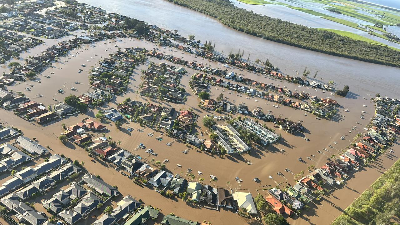
Evacuation order for Milperra, Chipping Norton
Residents in Milperra, Chipping Norton and Lansvale in Sydney’s south-west have been warned rising waters in the Georges River could leave them “isolated”.
“You may be trapped without power, water and other essential services and it may be too dangerous to rescue you,” an SES flood warning read.
The river is expected to reach moderate flood levels at Milperra and Liverpool by Thursday morning.
NSW Deputy Premier Paul Toole said residents should remain cautious about the ever-changing conditions.
“If you are asked to leave, please leave. Please do this for your own safety. Please do not contemplate on staying. Please do the right thing and don‘t risk your life at this point in time,” he said.
SES has warned Sydney residents living in low-lying areas not to wait for evacuation orders to leave their houses, particularly if they were impacted by flooding last year.
The Hawkesbury is tipped to reach major flood levels - over 10.5metres - tonight as the region is smashed by heavy rain with no immediate relief in sight.
Police save 93-year-old woman floating on her mattress
Two senior constables were conducting search and rescue operations in Lismore’s CBD when they heard a faint call for help from inside a flooded home.
One of the senior constables dove through an open window and found a 93-year-old woman floating on a mattress, with no more than 20cm of room between the roof and the water level.
The woman was pulled from the home on a boogie board, through the open window and onto a waiting rescue boat.
Fourth body found in Lismore, NSW
SES volunteers found the body of a man, believed to be in his 70s, inside a flooded apartment in South Lismore on Wednesday afternoon.
Earlier, authorities recovered the body of missing man Stuart Brock. His devastated daughter Crystal thanked locals for joining in the search, revealing her dad had been swept away in floodwaters on Sunday afternoon around 4.30pm.
The tragic discovery follows those of two women, 84-year-old Lorraine Hyman and beloved local singer Marge Graham, who were found inside their homes yesterday.
NSW Deputy Premier Paul Toole said his thoughts were with those who had lost loved ones.
“We know in realistic terms we may see more loss of life over the coming days,” he said.
“This is a catastrophic event.”
Gale force winds forecast
As the system deepens into an east coast low, it will bring “strong to gale force winds” and “huge swells” and is set to hit Sydney, the Central Coast and the Illawarra the hardest, Sky Weather chief meteorologist Tom Saunders said.
“[Some areas will see] over 100mm, some areas will see over 200mm of rain, and if we see some thunderstorms in the mix, then we could see life threatening flash flooding with 2000mm in just a six hour period,” Mr Saunders warned.
Sydney is set to be on the receiving end of the worst conditions over the next 48 hours, with SES spokesman Adam Jones asking residents to help the organisation by readying sandbags and preparing their homes.
“We are asking people to make sure your gutters are clean, if there is something to fly away, such as a trampoline, tie it down. Prepare yourself. Get some sandbags if your area is prone to flooding,” he said.
“The preparation stops jobs coming through and helps us. The less we have it makes a huge difference.”
Stream more weather news live & on demand with Flash. 25+ news channels in 1 place. New to Flash? Try 1 month free. Offer ends 31 October, 2022 >
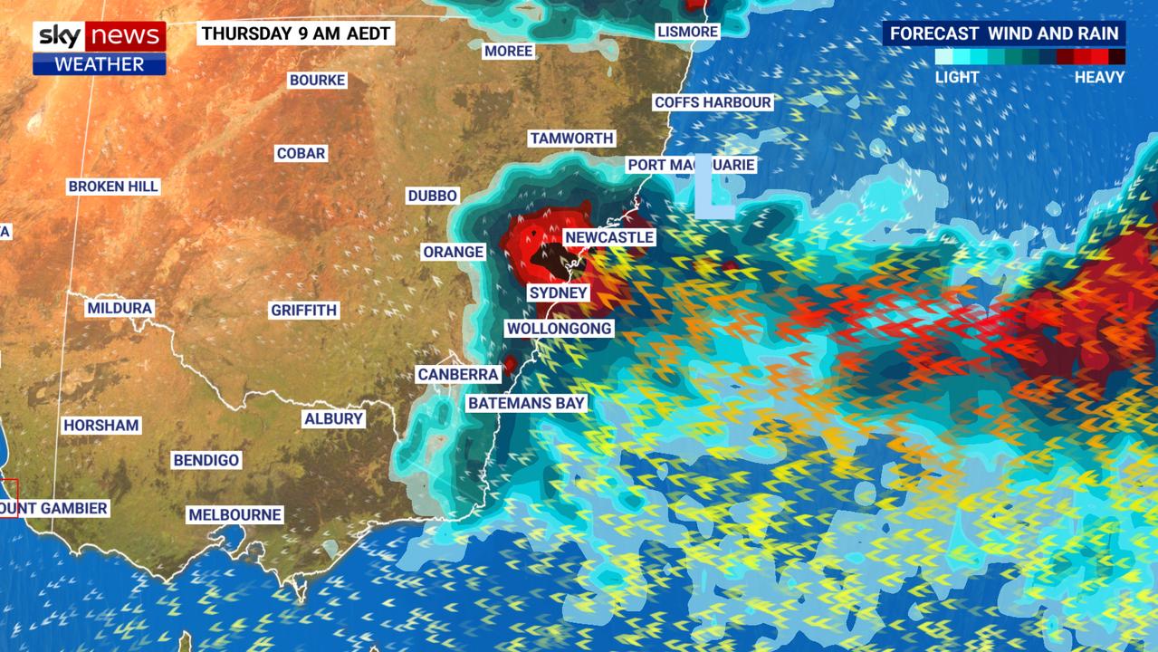
Bureau of Meteorology (BOM) senior meteorologist Jackson Browne told Today this morning that the low-pressure system that has caused the unprecedented rain and flooding would threaten a large part of NSW as it moves south, including Newcastle, the Sydney metropolitan area, Wollongong and the Blue Mountains.
The current forecast is for damaging winds and heavy rainfall to arrive today and carry overnight into Thursday. Sydney is expected to see up to 150mm throughout Wednesday.
Mr Browne said additional rainfall was also likely in areas already affected by flooding, including southeast Queensland and northeast NSW “with two storm days on Thursday and Friday, bringing with it damaging winds and some heavy rainfall”.
“It’s not the sort of rainfall that we saw on the weekend, but because everything’s so saturated, the bar is pretty low: Any rainfall will lead to some sort of flash flooding and additional rises,” he said.
Locals have been encouraged to pack emergency supplies and prepare for possible evacuation.
More information on evacuation alerts and centres is available at the SES website.
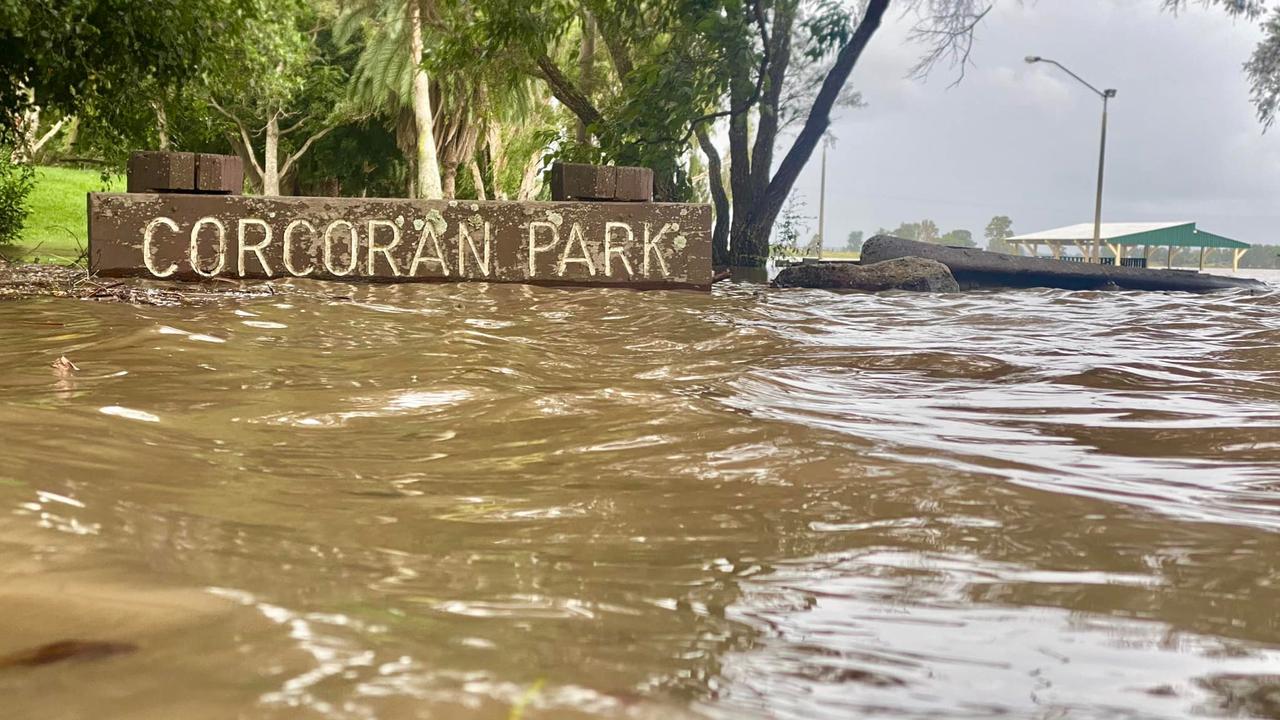
Major flood warning for Hawkesbury and Nepean
The Bureau of Meteorology has issued a warning for “major flooding similar to March 2021” in the Nepean and Hawkesbury River catchments.
“River level rises are occurring along the Nepean River where major flooding is possible from Wednesday afternoon,” the Bureau said.
“Along the Hawkesbury major flooding is possible from overnight Wednesday into Thursday at Penrith, North Richmond and Windsor based on forecast rainfall.”
âš ï¸Major #Flood Warning for #HawkesburyRiver & #NepeanRiver at #MenangleBridge, #Camden, #Wallacia, #Penrith, #NorthRichmond, #Windsor, #Sackville, #LowerPortland, #WisemansFerry#PuttyRd. See https://t.co/AdztI2rqg1 for details and updates; follow advice from @NSWSES. #NSWFloodspic.twitter.com/bpEC1bZQZL
— Bureau of Meteorology, New South Wales (@BOM_NSW) March 2, 2022
A major flood warning is also in place for the Clarence River at Grafton, Ulmera and Maclean for the remainder of Wednesday into Thursday.
More information on weather warnings in place is available at the BOM website.
Conditions in NSW ‘unfathomable’
Asked whether NSW could have been better prepared for the current emergency, Deputy Premier Paul Toole said the conditions were “unfathomable”.
“Everything is soaked. I mean we’ve got dams that are full, our riverways are full. The ground is saturated. Depending where rainfall lands, how heavy it is and how quickly it actually floods, that’s where we’re seeing areas of flash flooding,” Mr Toole told reporters.
“We’ve got levee banks around Lismore. They’re 10m. No one would have predicted we were going to see a 14.4m rainfall event or flooding in that area … You can always say ‘what if’, but we’re talking about 180mm of rain that fell in a 30-minute period of time [in Lismore].
“That’s seven inches of rain in old language. That is unfathomable. That’s an incredible amount of rainfall coming from the sky, landing in some part of Lismore. It doesn’t matter how high your levee banks are, you’ll see flooding with that rainfall.”
Warragamba Dam spills over
Sydney’s primary water supply, the Warragamba Dam, has started to spill, after reaching capacity yesterday.
Water NSW warned it may continue for up to two weeks, threatening thousands of homes in the Hawkesbury and Nepean area.
NSW Deputy Premier Paul Toole urged residents in the region to prepare themselves for the possibility they will be evacuated.
“Hearing from the Bureau of Meteorology there are real concerns over the next 24 hours to the amount of rainfall predicted. People need to prepare themselves to be evacuating if they are required to do so,” Mr Toole told reporters during an update.
“Don’t hold back. Don’t stay there. Don’t say the floodwaters never reached your house last time. This may see more people needing to be evacuated. People need to be on alert right now.”
The #WarragambaDam has hit capacity and has started to spill. While the dam spill was forecast, it has started earlier than predicted. Stay up to date and take all warnings seriously. For current warnings visit: https://t.co/I4qsVXddAe@BOM_NSWpic.twitter.com/42Ks6J8Hwp
— NSW SES (@NSWSES) March 2, 2022
Ballina evacuated as rising water wreaks ‘havoc’
The entire town of Ballina has been ordered to evacuate, as more than 2.5 metres of floodwater are predicted to hit the northern NSW area today.
Ballina Shire Mayor Sharon Cadwallader once again urged residents not to become complacent as the town braces for “unprecedented” flooding, with an evacuation order going out at 12.15am.
Among those evacuated were 55 patients from Ballina Hospital, who were moved to a makeshift emergency department at Xavier Catholic College.
While the final people were evacuated from Cherry Street Bowling Club at 3am, Ms Cadwallader told Today this morning that now was not the time to relax.
“Water is unpredictable. You really don’t know what it’s going to do today, so it is an evolving situation. We’re monitoring it very closely,” she said.
“We can’t rest on our laurels or become complacent about this. We don’t want people to think this is just a normal event. It is far from a normal event.”
The manager of Ballina’s community radio station, Jenny Ellenbroek, said flood water was at the door of the Cherry Street building, while the CBD lost power around 8.30am.
“The water is at the doors of the council chambers and the Paradise FM station – that whole Cherry Street area, the water is now knee-deep,” she said.
“High tide was at 9am, the water didn’t come in and we hope we’ve dodged a bullet.”
West Ballina was totally inundated, she added, saying that “lots of businesses out there have gone under”.
“We are in absolute awe and shock of this, because this is not generally what happens in Ballina, but of course it’s collided with a 1.8 metre high tide, it’s creating havoc,” she said.
NSW SES spokesman Andrew McCullough said warnings now cover an area of 10,800 people, with authorities predicting around 6000 properties in the Ballina area will be impacted by the rising Richmond River.
“Because it’s tidal, so close to the ocean, we will be watching this very closely over the coming hours where it ends up,” he said.
“We’ve sent out evacuations, certainly as a precaution, because we believe there will be a lot of water in Ballina in the coming hours.”
Sydney commuters urged to avoid unnecessary travel
Sydney commuters have been advised to avoid unnecessary travel.
Transport for NSW chief operations officer Howard Collins also said that those who must travel should allow plenty of extra time with Sydney Trains and NSW TrainLink networks expected to be impacted.
“Our number one priority is safety. Motorists should exercise extreme caution and never drive through floodwaters,” he said.
“We ask our customers to postpone their journey if possible or to allow plenty of additional travel time. We want to ensure everyone arrives at their destination safely.”
Speaking to 2GB’s Ben Fordham, NSW Transport Minister David Elliott said the “awful” weather was causing delays on the city’s public transport system but adjustments were being made for the morning commute.
“As we forecast yesterday, the ferry services out of Manly have been dropped to every 40 minutes … commuters need to be conscious of extra time being required,” Mr Elliott said.
“The Parramatta River being what it is means the river service will be stopping at Rydalmere but there are arrangements for transfers between Parramatta and Rydalmere.”
Trains on the Blue Mountains line are also experiencing delays, but, Mr Elliott said, the rest of the network was so far coping fine.
“We’re talking about some of the most ruthless storms we’ve seen in this state in the past decade … commuters can have confidence in their normal journey with a few exceptions, but please be very cautious,” he said.
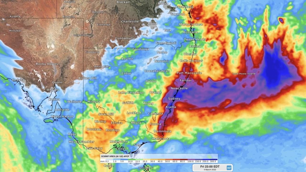
Wet weather to last into the weekend
Floodwaters are still flowing through many rivers and towns in northern NSW and southeast Queensland, with major flood warnings and evacuation orders still in place for multiple areas.
Emergency Services Minister Steph Cook said NSW has “never seen floods like this” in the northern parts of the state.
“The scenes have been truly distressing,” she said. “Things are not going to get much better up there for a little while.”
NSW SES deputy commissioner Daniel Austin told ABC News Breakfast authorities expect the treacherous weather conditions to last into the weekend.
“We’re expecting to see very heavy rainfall today. It is already raining in most of these parts now. It’s started either late yesterday or overnight, depending on where you are,” he said.
“We’re expecting to see that very heavy rainfall intensify through the day, continue through tomorrow, and probably before it starts to back off, we’ll probably be into the weekend. So a long way in front, with that heavy wind, with that heavy rain comes strong and damaging winds as well, as is normal with an east coast low.”
More Coverage

Mr Austin urged people to avoid unnecessary travel, and for those who live in a low-lying area near a river to be on alert for flood risk.
“We’re also going to see quite a bit of flash flooding because of the intense nature of some of the rainfall,” he said.
“So, again, we’re asking people to limit their non-essential travel. Stay off the roads as best as possible. But very much we’re asking people to be aware of their surroundings. Don’t just stay indoors, keep your eyes out to what is going on around you. Stay across the warnings, be aware of your circumstances.”
Join the conversation

‘Get your home ready’: Grim BoM warning
Read more

‘Appalling’: Arson suspected in vicious bushfire
Read more

Heatwave, icy blast splits Australia
Read more