
‘Remarkable’ rain and searing heat during extreme weather week
Every southern mainland capital could hit 40C+ this week as a blistering heatwave barrels across the country. But further north, floods are the issue.


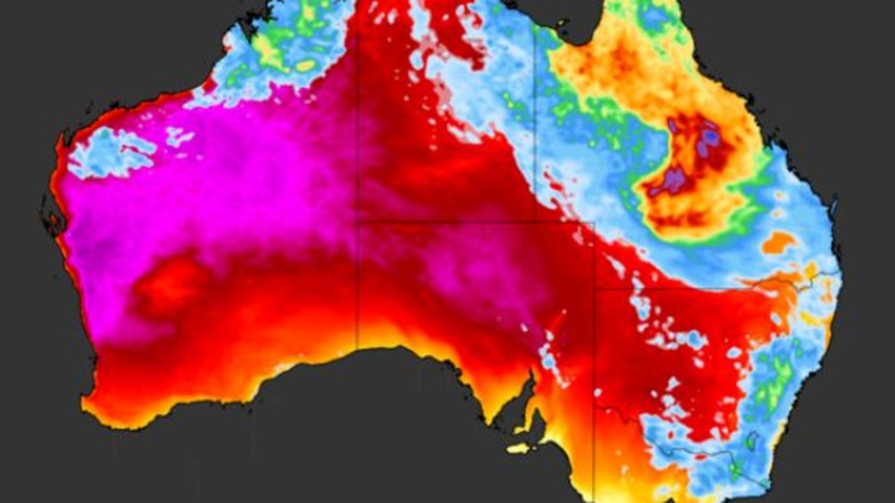
Every single mainland southern capital could hit at least 40C in the coming days as a wave of scorching air rolls across the Nullarbor and towards the country’s south east.
Adelaide, Melbourne, Sydney, Hobart and Canberra are all forecast to swelter this week with barely a break from the blistering heat until Sunday for most parts.
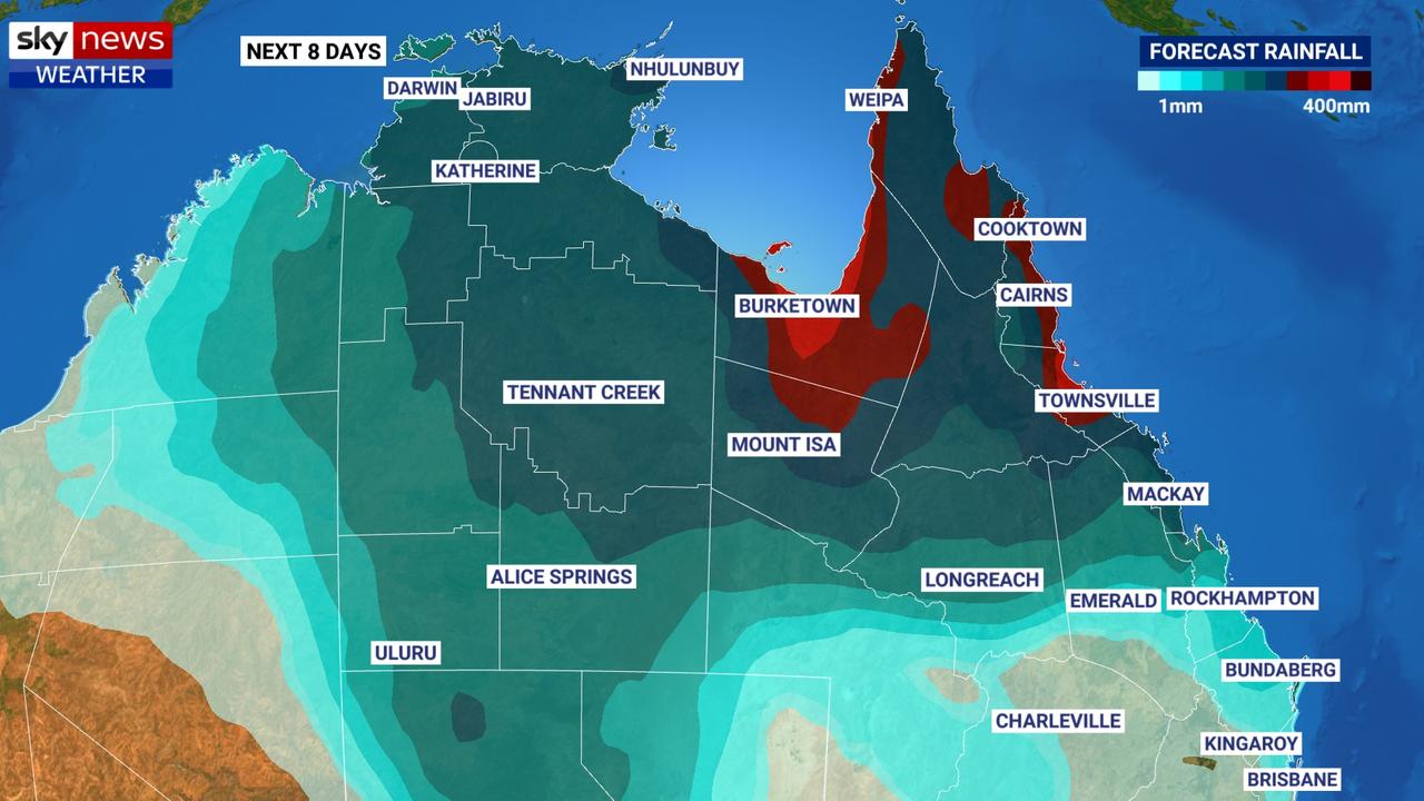
However, further north in Queensland vast swathes of the state are on flood watch as slow moving monsoon rains deluge places such as Townsville, Cairns and the Gulf Country.
In the last 24 hours, more than 100mm of rain has fallen on Townsville and Gregory Downs, south of Burketown.
The Bureau of Meteorology (BOM) has issued a severe weather warning for heavy rain and flash flooding across the Gulf Country and there are currently flood warnings in place for nine rivers.
A tropical low near the northern NT/Qld border will move back into the #Barkly on Wed. Heavy falls will return to the region and a Flood Watch remains in place. Find the latest watches and warnings at https://t.co/5q616PQXwx pic.twitter.com/HlzJqvghvg
— Bureau of Meteorology, Northern Territory (@BOM_NT) January 26, 2020
“The rain will continue over the next few days as far south as Mackay,” said Sky News Weather channel meteorologist Rob Sharpe.
“By the middle of next week, the rain shifts westwards with heavy falls in the Northern Territory. Then the low looks to dissipate and merge into a low pressure trough drifting all the way down into South Australia where heavy falls are possible in the west and far south of SA, then potentially into Victoria and New South Wales.”
‘BEST RAIN IN YEARS’
Effectively the rain could do a vast spiral, heading west from the Queensland coast, then south, across Victoria and potentially back up to the east coast again.
“There will be some handy rain on the cards for many areas but there will be some pretty remarkable rain for western parts of South Australia where it’s looking like the best rain in years for the Nullarbor and Ceduna,” said Mr Sharpe.
Average January rainfall in Ceduna is a mere 8mm. But Friday and Saturday could see between 8mm and 20mm of moisture on both days.
THE HEAT
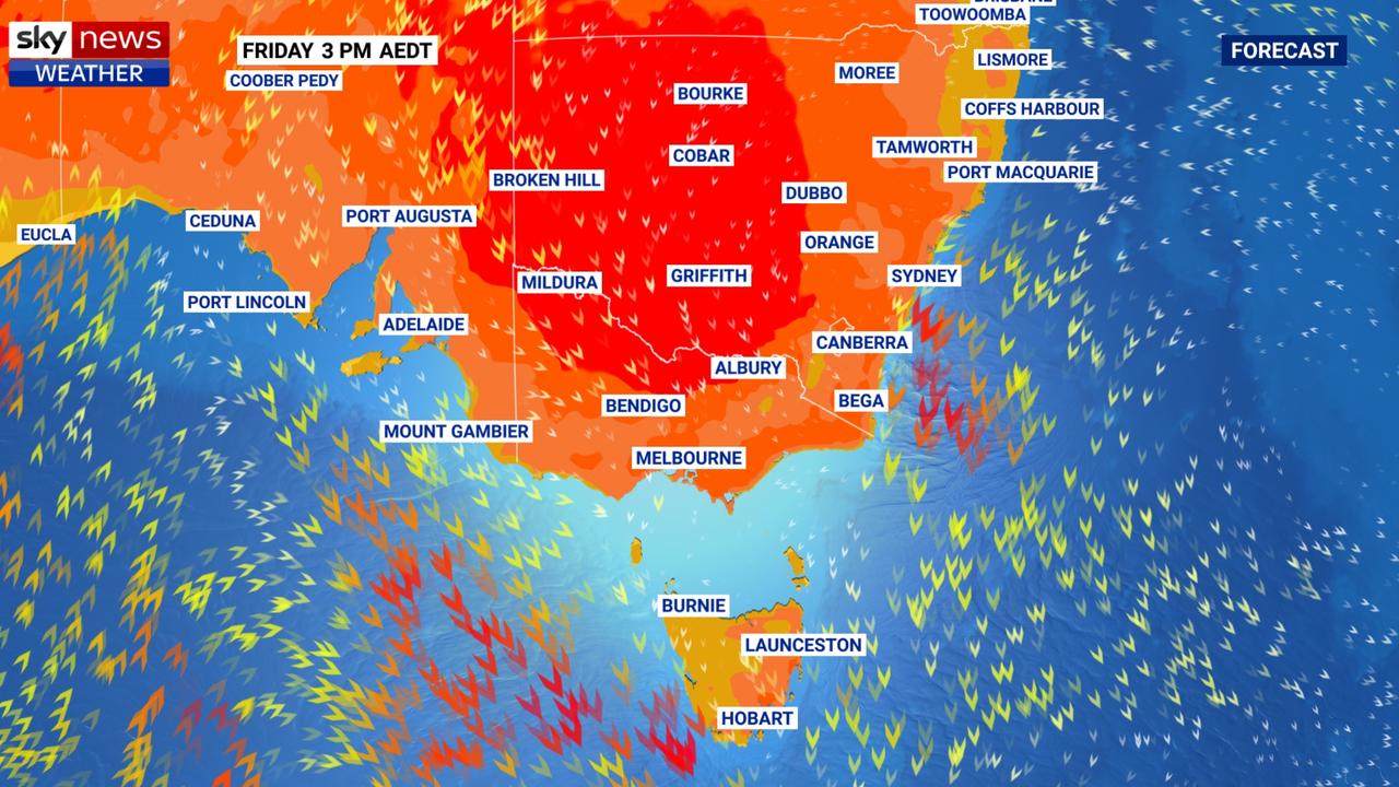
In the southern states there may be some rain but the defining feature of this week’s weather will be heat. Sticky, keep you up at night, kind of heat. And lots of it.
“It’s very hot in the west at the moment and the heat will slowly drift eastwards and then focus down on the south east,” Mr Sharpe said.
“By the time we get to back end of the coming week we’re looking at severe heatwaves likely to hit Melbourne, Adelaide, Canberra, and parts of Sydney.”
The BOM defines a heatwave as a run of three or more days of unusually high maximum and minimum temperatures. Severe heatwaves are a particular challenge for those over 65, pregnant women, babies and young children, and those with a chronic illness.
From Wednesday onwards a severe heatwave is set to engulf the south east including Adelaide, Melbourne, Hobart, Canberra and Sydney.
Canberra and eastern Tasmania could see an extreme heatwave from Thursday, which is dangerous for just about anyone.
It will be a warm day in Perth today where the heat destined for the east has been brewing up nicely. A high of 33C tomorrow and then highs in the mid-20s for much of the rest of the week.
Adelaide will see 30C today but the mercury is set to soar, hitting 42C on Thursday before the rain band comes through on Saturday bringing temperatures down to 27C. Up to around 25mm of moisture could fall on the weekend.
Cooler in Melbourne with a high of 23C today but scorching later this week topping out at 37C on Thursday and 41C on Friday. Storms and showers possible on the weekend as the cold front and rain barrel through.
Much the same cycle in Hobart. A cool 23C today with cloudy skies and then getting warmer each day until it hits 38C on Friday. Downpours on Saturday will then coincide with a temperature drop.
Canberra is set to bake through a week of unremitting heat. A high of 35C today will set the tone but there will be a jump to 39C on Thursday and then two days with highs of 41C from Friday. The heat will lessen on Sunday, but only into the mid-30s. There might be some splashes of rain on Sunday in the capital.
Sydney will also see a heat spike but there will be more manageable days beforehand in the CBD at least. Highs of 30C today and for much of the week then a jump to 36C on Sunday. Far warmer in the city’s west, however with 37C today in Penrith and a high of 44C on Saturday.
Brisbane may see a few spots of rain today but nothing like further north in Queensland. Highs of between 31-34C this week.
Wet and stormy in Darwin with highs of 33C all week.
Extreme heatwave warning for Aussies
A very hot air mass is sloshing around the country, causing temperatures to reach the mid-to-high 40s over several states.
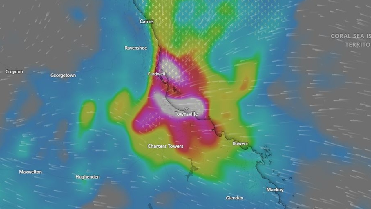
Devastating floods claim another life
Another person has died in flooding that is devastating large parts of the North Queensland coast, in scenes of “incredible devastation”.
‘Hoodwinked’: China is conning the world
An Australian economist says China is conning the world on an important global issue.