
Australia weather: ‘Severe’ hailstorm hitting Sydney
Severe thunderstorm warnings including large hailstones and strong winds shocked in Sydney and its surrounding areas overnight.
Severe thunderstorms bringing large hailstones and strong winds are headed towards Sydney and its surrounding areas this evening, the Bureau of Meteorology has warned.
It says the storms were detected on the weather radar near Sutherland and Penrith at 6.35pm. “These thunderstorms are moving towards the east,” it said.
“They are forecast to affect Hornsby, Parramatta and Richmond by 7:05pm and Sydney City, Sydney Olympic Park, the Sydney Harbour Bridge, Mona Vale and waters off Bondi Beach by 7:35pm.
“Damaging winds and large hailstones are likely.”
Welcome to the first day of an Australian Summer . #Sydney 🇦🇺 pic.twitter.com/0mtGwLwt1m
— Saint Sam 😈 (@dude_brick) December 1, 2020
Bit of a storm brewing! #sydney #lightning #australia pic.twitter.com/WVrEBrYdeF
— Nick Lagos (@whatsatruck) December 1, 2020
It warned residents in affected areas should move their car under cover or away from trees, and to secure or put away loose items around their house, yard and balcony.
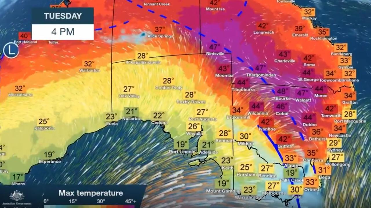
Forecasters have said eastern Australia is in the grip of a “pretty remarkable” weather event with a burst of heat lingering around the interior and the possibility of yet more temperature records to tumble.
A string of towns in western New South Wales are creeping up towards the 50C mark. Bourke could break 48C on Tuesday which would only be a whisker away from its highest temperature since modern records began at the site in 1910.
It comes just days after Sydney hit its hottest November overnight temperature as well as an unparalleled two-day run of heat.
Sydney and Brisbane could be toasty again with both city’s western suburbs rising towards and in some cases exceeding 40C. But the cool change that has galloped through further south should keep many other capitals cooler.
“While heatwaves are normal for this time of year, what’s making this burst of heat exceptional is temperatures 18-20C above average and many locations breaking records,” Bureau of Meteorology forecaster Dean Narramore said.
There are warnings that Tuesday could lead to the ideal conditions for thunderstorm asthma to develop with potential storms rolling up the NSW coast. And the hot weather is also ramping up fire weather warnings further inland.
RELATED: Horror images as Fraser Island inferno worsens
RELATED: Sweltering temperatures ring in Sydney summer
“There’s some pretty remarkable weather today and during the coming week with heat lingering on and battling a cool change in the southeast and that’s causing some severe weather,” Sky News Weather meteorologist Rob Sharpe said.
Walgett, in northern NSW, is looking at 47C as is Thargomindah in southwest Queensland. For many inland areas the scorching conditions seem in no mood to end just yet with days of temperatures in the high 30s.
“The winds are feisty today and that’s leading to dangerous fire weather particularly in hot grasslands area,” Mr Sharpe said.
Severe fire weather warnings are currently in place from much of southern Queensland, inland NSW and northern Victoria.
Sydney’s CBD will be relatively mild today topping out a 29C, but expect 41C in Penrith, in the city’s west, with possible storms. It will be cooler in the coming days as that cold front passes, but it it’s going to heat up again towards the weekend.
Mr Sharpe also warned asthmatics should pack their inhalers.
“There is a thunderstorm asthma risk for people in south east NSW and the ACT. Storms can break up the high pollen count leading to significant risk for asthma sufferers.”
In Brisbane, the mercury is expected to hit 32C today and 34C tomorrow in the CBD. The further west you go the warmer it gets with Ipswich on 36C on Tuesday rising to 40C on Thursday and then bobbing around the high 30s and low 40s for much of the next week.
“A cold change is expected across southeast Queensland on Thursday with temperatures dropping but elsewhere it remains hot,” Mr Sharpe said.
RELATED: Bushfire season kicks off as heatwave hits
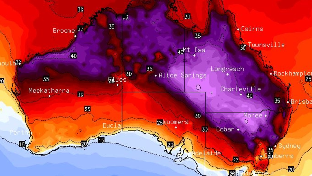
The BOM’s Mr Narramore said the heat was building up in Central Australia and then being dragged towards the coast by cold fronts that were leading temperatures to “soar” across wide swathes of the east.
Canberra is set to hit 35C on Tuesday before falling into the mid-20s for the rest of the week.
A mild 27C is expected in Melbourne and then a drop to 19C on Wednesday. That will set the tone for the rest of the week. There will be similar conditions for Hobart but there could also be a shower or two in Tasmania.
Perth will see a sunny week with temperatures generally in the mid-20s but Thursday could get to 31C with a warm weekend beckoning.
Adelaide will have a run of very manageable days around 21C rising towards the 30C mark on Friday before dipping down again.
In the Top End the weather remains stormy. Darwin will see a 34C high and afternoon unsettled conditions.

‘Bigger, more frequent’ hail for Aus cities
Younger Aussies are being warned to expect bigger and more frequent hail into the future, with a new study revealing which cities are most at risk.
Read more

‘Total madness’: Net-zero review slammed
The Nationals' push to abandon net-zero targets has been slammed as Australia grapples with its role as a major fossil fuel exporter.
Read more

Snow predicted in surprising state
Residents of a state renowned for its beautiful beaches and tropical climate have been warned to prepare for potential snow this weekend.
Read more